
13 Jan High resolution landslide susceptibility map of India
This article covers ‘Daily Current Affairs’ and the topic details of “Development of high resolution landslide susceptibility map of India’’. This topic is relevant in the “Disaster and geography” section of the UPSC CSE exam.
UPSC MAINS GS1,3 Syllabus : Disaster and disaster management, Important geophysical phenomenon such as earthquakes, landslides etc.
Why in the News ?
The first high-resolution landslide susceptibility map of India has been developed by the Indian Institute of Technology Delhi, Since it covers the entire nation and excludes no area, it is the first of its type.
About National Landslide Susceptibility Map
- Detailed Mapping: Having a resolution of 100 square metres, this high-resolution map provides an extensive perspective of India’s susceptibility to landslides, highlighting hitherto unidentified places.
- Exploring New Risk places: The map broadens the scope of places that need to be monitored for landslides by identifying not only typical high-risk zones but also recently unknown locations of concern.
- Unique Analysis Technique: To increase forecast accuracy and close data gaps in uncharted territory, the mapping made use of an ensemble machine learning technique.
- Advantages of Ensemble Models: This method expertly combines several models, providing a more reliable evaluation of landslip risks.
Process of Data collection and Analysis :
- Data Collection: Data from several sources, including the Geological Survey of India, were combined with information on about 150,000 landslip incidents by scientists.
- Identification of Contributing Factors: The research team discovered 16 significant elements impacting the susceptibility to landslides by using instruments like GeoSadak for remote data collection.
Benefits of such maps
- Permanent Danger : Landslides, which affect a large but restricted area of India, are a recurrent concern, especially in hilly regions.
- Challenges of Management : Historically, the localised and intermittent nature of landslides has made it difficult to monitor and predict the event, highlighting the need for an all-encompassing mapping system.
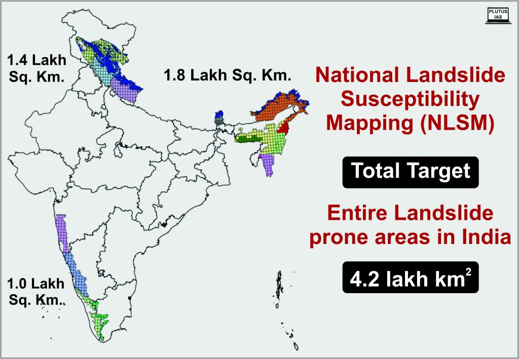
Programme for National Landslide Susceptibility Mapping (NLSM)
1) In 2014, the Geological Survey of India launched the National Landslide Susceptibility Mapping (NLSM) programme at a Macro Scale of 1:50,000.
2) Mapping the 0.42 million sq. km of terrain that is vulnerable to landslides nationwide is the aim.
3) Aim of the programme :
A) To establish a comprehensive National Landslide Susceptibility Geodatabase for India.
B) To create continuous, 1:50,000 scale GIS-based maps of India’s landslip susceptibility.
C) To create a national GIS-based landslide inventory repository.
About Landslides :
A landslip is defined as a mass of rock, earth, or debris sliding down a slope.
Areas at Risk of Landslides: Areas at risk of landslides are generally those with less trees, those near road construction, and locally steeper slopes. These areas are also more unstable.
Causes of Landslide
Natural Causes: earthquakes, undercutting of slopes due to flooding or excavation, snowmelt, Rainfall, etc.
Anthropogenic Causes: Mining, excessive development, Overgrazing by cattle terrain cutting and filling.etc.
- External causes of landslide are –
Undercutting of the hillside’s base as a result of quarrying, excavating for roads and canals, and river erosion, among other reasons.
- An increase in external loads, such as those from structures, reservoirs, vehicles, rock piles, alluvium buildup on slopes, etc.
- Increased water content causes a rise in the slope material’s unit weight.
- Vibrations brought on by blasting, traffic, earthquakes, etc. that raise shearing strains.
- Human alterations brought on by deforestation
- Tunnelling, cavern collapse, seepage erosion, etc. all result in undermining.
2. Internal causes of landslides are –
- A rise in the pressure of pore water.
- Decline in cohesive capacity produced by gradual lateralization.
- Cracks brought on by tension-induced alternating swelling and shrinking.
- The existence and orientation of faults, joints, bedding planes, cleavage, etc.
- The heating and cooling of rocks and soils.
- Earth material’s physical characteristics, such as its compressive and shearing strengths.
Impact of Landslides
- Effect on the Economy: Property is destroyed by landslides. Millions were spent on its reconstruction and restoration.
- Infrastructure Damages: A landslide’s forceful flow of mud, rocks, and debris can seriously harm people’s personal belongings as well as important infrastructures including roads, trains, recreation areas, buildings, and communication systems.
- Death toll: Landslides are more likely to occur in communities near the base of hills and mountains. Because most disaster-prone places are densely populated, people’s lives are made much more unpleasant.
- Impacts landscape beauty: The movement of dirt, rock, and other material ruins a location’s natural appearance.
- River ecosystems in decline: The materials that landslides carry with them obstruct or impair the natural flow of these systems. Because it tampers with the normal movement of water, fish, which are found in many river environments, may perish.
- Trigger Flood: It may result in the diversion of river water, which may cause flooding and property loss in some locations.
- Impact on daily wages: Communities who rely on the beaches or rivers for irrigation, household chores, and other purposes will be negatively impacted.
Mitigation
- Region-Specific Measures: Whenever possible, it’s best to cope with landslides by implementing area-specific measures.
- Afforestation: Some constructive measures include advocating for extensive afforestation initiatives and building bunds to slow down water flow.
- Limitations on Construction: It is important to enforce restrictions on the construction of roads, dams, and other developmental projects, to restrict farming to valleys and regions with mild slopes, and to control the growth of large settlements in high-vulnerability zones.
- Early Warning and Monitoring System for Landslides: To notify residents in regions at risk of landslides ahead of time in order to reduce the loss.
- “Hazard maps” are used to identify regions that are vulnerable to landslides. Therefore, it is best to avoid developing communities in such places.
- Terrace Farming: In the hill states of the northeast, where Jhumming (Slash and Burn/Shifting Cultivation) remains common, terrace farming should be promoted.
Conclusion
Disasters caused by landslides are usually far less dramatic than those caused by earthquakes, volcanic eruptions, tsunamis, and cyclones, yet they still have just as devastating an impact on the environment and the nation’s economy.They are typically impacted by extremely localised variables, compared to other disasters that are abrupt or unanticipated, and are generally governed by macro or regional forces.
Prelims practice question
Q1) What role does heavy rainfall play in triggering landslides in the Himalayan region of India?
1 Heavy rainfall is not a significant factor in Himalayan landslides.
2 Heavy rainfall can saturate the soil, leading to increased landslide risk.
3 Heavy rainfall stabilizes the soil, reducing the likelihood of landslides.
Which statement is correct?
A) 1 only
B) 2 only
C) 3 only
D) 2 and 3
Answer: B
Q2) Which of the following statements regarding landslides is correct?
1) Landslides are exclusively caused by human activities.
2) Landslides can occur only in mountainous regions.
3) Excessive rainfall is a common trigger for landslides.
Which of the following statements are incorrect?
A) 1 only
B) 1 and 2
C) 2 and 3
D) 1 and 3
Answer: D
Mains practice question
Q1) Analyze the role of community engagement and awareness programs in landslide risk reduction. How can the NDMA work with local communities to enhance their resilience and preparedness for potential landslide events?
Q2) Discuss the role of the National Disaster Management Authority (NDMA) in mitigating and managing landslide risks in a country. How does the NDMA collaborate with other agencies and communities to enhance landslide preparedness and response?
- Accreditation of NHRC by GANHRI postponed - May 15, 2024
- Interim Bail granted to Delhi CM by Supreme Court - May 13, 2024
- Old trade route uncovered by inscription at Hoysala’s temple - May 10, 2024

No Comments