
10 Jan Joshimath crisis
- NISAR (NASA-ISRO Synthetic Aperture Radar) MISSION - February 10, 2023
- Lab Grown Diamonds - February 9, 2023
- Muons Particles - February 8, 2023
Joshimath crisis
This article covers “Daily current affairs for UPSC” and the topic is about the ‘Joshimath Crisis’ which is in the news, it covers the “Land subsidence” In GS-3, and the following content has relevance for UPSC.
For prelims: Geography of Joshimath and places around
For mains: Natural disasters, Floods, Land subsidence
Why in news:
The announcement was made following a high-level meeting between senior Central government officials, representatives from the state of Uttarakhand, and senior executives from organizations such as the National Disaster Management Authority (NDMA), Geological Survey of India (GSI), and the National Institute of Hydrology (NIH).
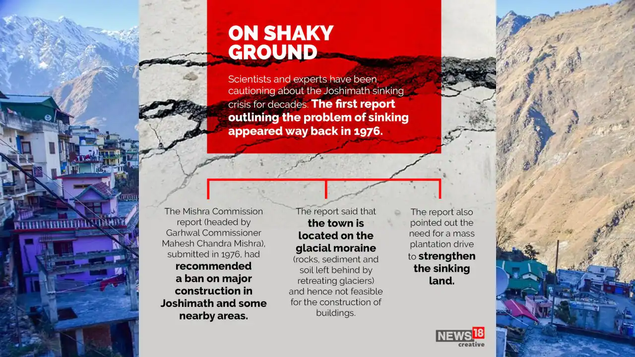
According to a study by the Uttarakhand State Disaster Management Authority (USDMA), the town is located in a landslide-prone area, and the first instance of subsidence there was detailed in a 1976 Mishra Commission report.
Location of Joshimath
- Joshimath, a town in the Garwhal Himalayas, is a significant stopping point on both the pilgrimage and hiking routes.
- It is located at an elevation of 1890 meters. However, the settlement of over 20,000 people is also situated on a precarious mountain slope that has been made even more precarious by haphazard and indiscriminate growth.
- On the Rishikesh-Badrinath National Highway (NH-7) in Uttarakhand’s Chamoli district is the highland town of Joshimath.
- The town is used by tourists who are traveling to Badrinath, Auli, the Valley of Flowers, Hemkund Sahib, and other significant religious and tourism destinations in the state as an overnight rest stop.
- One of the most significant cantonments for the Army is located in Joshimath, which is also of tremendous strategic importance to the Indian armed forces.
- Running streams with a steep gradient originate in Vishnuprayag, a confluence of the Dhauliganga and Alaknanda rivers, and they pass through the town (which is located in seismic zone-V with high risk).
Geology
- The study emphasized how the Joshimath region is extremely susceptible to subsidence due to eco-tectonic, geomorphic, and climatic elements combined.
- Joshimath, which is in the Chamoli district and is located in Zone V of the Seismic Zonation Map, has seen several earthquakes with Richter magnitudes under 5.
- Vayikra Thurst (VT), a tectonic fault line, is practically directly beneath Joshimath. The town is also extremely near two major geological fault lines, the Main Central Thrust (MCT) and the Pandukeshwar Thrust (PT).
- The Town is located under Helang, a little to the south of Joshimath Town, where MCT juxtaposes with rocks from the Garhwal Group (Joshimath Formation), placing it in the effect zone of any tectonic activity on MCT.
- The Border Roads Organization (BRO) is constructing a bypass at Helang. Which will cut the journey to the Badrinath shrine by around 30 kilometers. According to experts, the “earth tectonic activity” underneath may cause more landslides.
- In 1976, the Mishra Commission report—headed by MC Mishra, recommended significant construction in the vicinity of Joshimath.
Reasons behind the sinking of Joshimath
- A 1976 Mishra Committee investigation states that Joshimath is located on a layer of sand and stone rather than the main rock, which is where the ancient landslide that caused it occurred. On an old landslide, it is situated. According to the paper, the Alaknanda and Dhauliganga rivers’ currents also contribute to the occurrence of landslides by undercutting the ground.
- Restrictions on heavy construction activities, blasting or excavating to remove rocks for road repairs and other works, and tree cutting were among the committee’s recommendations.
- Geographically, boulders, gneissic rocks, and loose soil with a limited bearing capacity are covered by old landslide debris on the area’s dispersed rocks.
- These gneissic rocks are severely worn, have a low cohesive value, and have a propensity for high pore pressure when wet, particularly during monsoons.
- Unplanned Construction activities: Over the past two decades, increased construction, hydroelectric projects, and the enlargement of the NH have rendered the slopes extremely unstable.
- Land Erosion: The city’s fate is also attributed to the flowing waters from Vishnuprayag and sliding along the natural waterways.
Joshimath crisis
Land subsidence of Jashimath
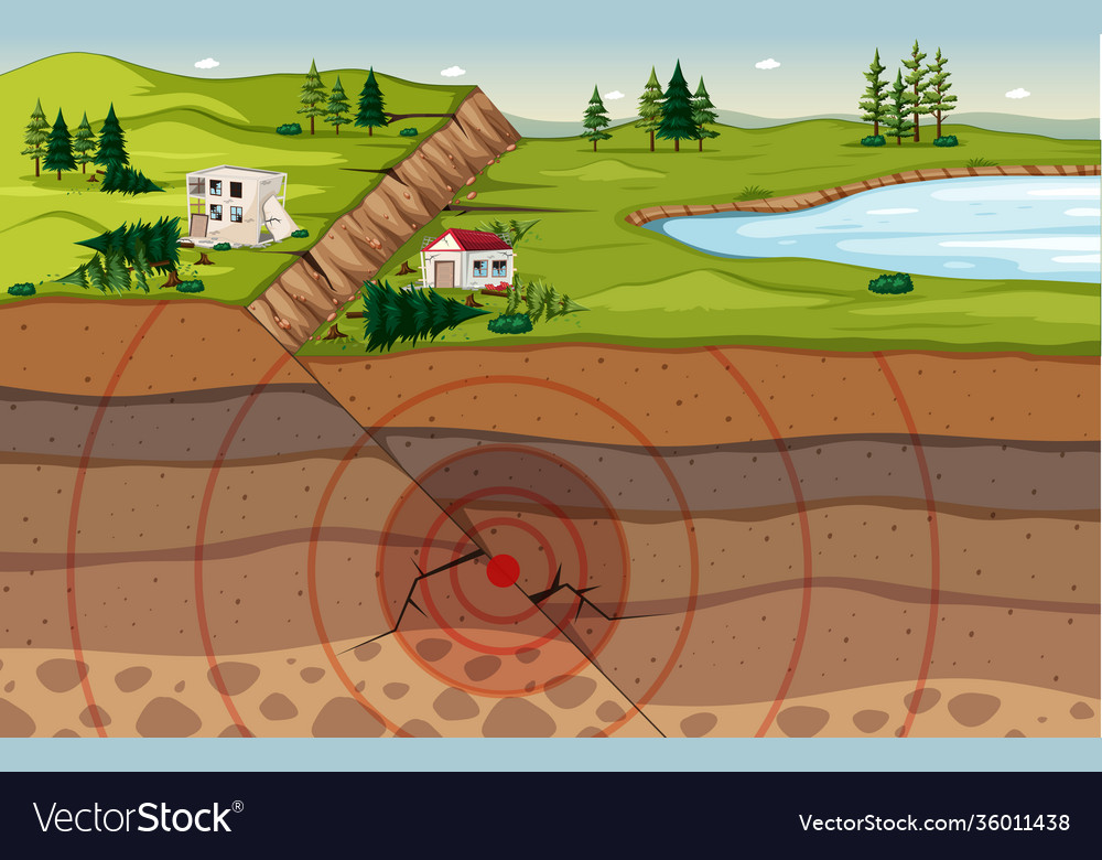
- The term “land subsidence” refers to the slow settling or abrupt sinking of the Earth’s surface as a result of the loss or movement of subsurface earth elements.
- The surface of the Earth may drop suddenly or gradually through land subsidence.
- The most frequent cause of subsidence, which is the sinking of the ground as a result of underground material movement, is the removal of water, oil, natural gas, or mineral resources from the earth through pumping, fracking, or mining activities.
- Additionally, subsidence can result from natural occurrences including earthquakes, soil compaction, glacial isostatic adjustment, erosion, the creation of sinkholes, and the addition of water to fine soils deposited by wind (a natural process known as loess deposits).
Recommendations of Mishra Committee Report
- Limitations on heavy buildings should be put in place, and slope excavation should also be restricted. Construction should only be permitted once the stability of the site and the soil’s ability to support loads has been assessed.
- Keeping the boulders: In landslide-prone places, it is important to avoid removing rocks and boulders from the hill’s base because doing so would reduce the toe support and raise the risk of landslides.
- Crack sealing: It is important to seal any cracks that have formed on slopes. The bottommost portion of a landslide is known as the toe.
- Tree plantation: It also suggested against felling trees in the landslide zone and suggested that significant planting be done there, especially between Marwari and Joshimath.
- It is forbidden to cultivate on slopes: Plowing, for example, loosens the soil, creating the potential for landslides.
- Water seepage Control: To stop the seepage of open rainwater, a pucca drainage system must be built. This will help to prevent future landslides.
- Cobbled roads: Cobbled roads must be metalled and free of scuppers, which remove water from the road surface.
- River training: It is important to build structures to direct the flow of the river. There should be adequate support for hanging boulders on the hillsides.
Way ahead
- Keeping people safe should be a top focus right away. The state administration needs to open up a direct line of communication with the impacted citizens.
- A reconstruction strategy with a deadline must be created.
- Seismic monitoring must be done continuously.
- Joshimath should also have a risk-sensitive urban development plan created.
UPSC Civil Services Examination Previous Year Questions (PYQs)
Q. Bring out the causes for more frequent landslides in the Himalayas than in the Western Ghats. (2013)
Q. Describe the various causes and effects of landslides. Mention the important components of the National Landslide Risk Management Strategy. (2021)
Source:
Daily Current Affairs for UPSC
Get the best and latest daily current affairs for the UPSC examination from Plutus IAS free of cost. Daily Current Affairs increase not only your general knowledge but also helps the UPSC exam preparation. Also, read weekly, and monthly Current Affairs today for IAS exam preparation.

No Comments