
18 Oct India and Nepal Border Disputes:
This article covers “Daily Current Affairs” and the topic details “India and Nepal Border Disputes”. This topic has relevance in the International Relations section of the UPSC CSE exam.
For Prelims:
About the Sugauli Treaty of 1816?
About Rivers Forming the Boundaries?
For Mains:
GS 2: International Relations
Strategic Significance of Lipulekh and Kalapani?
Recommendations for Resolving India-Nepal Border Disputes?
Why in the news?
Prime Minister Narendra Modi’s visit to Gunji near Kalapani, Uttarakhand has sparked controversy in Nepal. Opposition parties in Nepal have alleged that Modi visited “our territory” without notifying their authorities and are demanding an explanation for how this occurred.
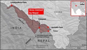
Kalapani-Limpiyadhura-Lipulekh Tri-Junction:
- Covering a vast expanse of over 1,700 kilometers, the border between Nepal and India stems from the historical 1816 Sugauli Treaty. This treaty marked the conclusion of the Anglo-Nepal War and delineated the border, with particular focus on the disputed Kalapani-Limpiyadhura-Lipulekh region, which remains a point of contention to this day. Notably, both nations have included this region in their official maps, even though it is under India’s administration.
Sugauli Treaty of 1816: The Sugauli Treaty of 1816 played a pivotal role in defining Nepal’s territorial boundaries following the Anglo-Nepalese War of 1814-1816. This treaty, signed on March 4, 1816, between the British East India Company and Guru Gajraj Mishra, holds historical significance as it resulted from the conflict between the Gorkha Kingdom of Nepal and the British East India Company.
Key Provisions of the Treaty:
- Boundary Determination: The Treaty of Sugauli marked the formal establishment of Nepal’s boundary, with the Kali River designated as the western border and the River Mechi as the eastern border.
- Absence of River Origin: Although the treaty defined the Mahakali River as Nepal’s western boundary, it did not specify the origin of the river, a detail of utmost importance when a river is used as a country’s border.
- Shifting Boundaries: In the years following the treaty, maps produced by the British East India Company depicted the origin of the Kali River near the Limpiyadhura pass to the west. However, recognizing the strategic trade significance of this pass, the Company gradually shifted the border eastward, resulting in the Kalapani region.
- Nepal’s Response: Surprisingly, Nepal’s ruling monarch did not raise objections to these boundary shifts, which ultimately led to the establishment of the modern border between India and Nepal.
Origin of the Border Dispute:
- Nepal contends that the origin of the Mahakali River (known as River Kalee) lies in the vicinity of Limpiyadhura or the nearby Lipulekh pass. This assertion forms the basis of Nepal’s claim to the Limpiyadhura area as an integral part of its territory, particularly at the trilateral junction between India, Nepal, and China.
India’s Stand:
- India, on the other hand, maintains that the River Kali originates from a smaller stream called Pankhagad, situated to the south of Kalapani. According to India, the true border runs along the eastern ridge of this region, which it considers a part of its territory.
Confusion Amidst Different Names:
- The complexity of this dispute is further exacerbated by the varying names of the river along its course. It is referred to as ‘Kali’ in its upper reaches, ‘Mahakali’ in the middle section, and ‘Sarjoo’ or ‘Gogra’ in the lower part. These name variations contribute to the confusion surrounding the river’s true origin and ownership.
Strategic Significance of Lipulekh and Kalapani: The region of Lipulekh and Kalapani, forming a trijunction between India and China, holds immense geostrategic and geopolitical importance.
Several key factors underline this significance:
- Surveillance and Border Security: India’s presence in Lipulekh and Kalapani enables close monitoring of any potential incursions by China or the movements of the People’s Liberation Army (PLA) towards Indian territory. This strategic positioning serves as a crucial buffer against possible threats.
- Geopolitical Implications: Kalapani, in particular, has not been immune to the geopolitical dynamics involving China. During the 2018 Doklam standoff, China raised the prospect of entering the Kalapani region as a response to India’s presence in various trijunctions. This underscores the region’s role in wider geopolitical considerations.
- Geo-Economic Significance: Beyond its military and strategic importance, the region holds geo-economic value. It serves as the most direct and shortest route from North India to Kailash Mansarovar, a highly revered pilgrimage destination. Currently, Indian pilgrims have to choose longer routes through Nepalgunj-Humla or Kathmandu-Kerung to reach Kailash Mansarovar.
Present Status of Border Disputes Between India and Nepal
Kalapani-Limpiyadhura-Lipulekh Dispute:
- The Kalapani-Limpiyadhura-Lipulekh tri-junction continues to be a point of contention between Nepal and India. Successive governments from both nations have engaged in discussions, yet a mutually agreeable resolution remains elusive, and both countries assert their claims over this region.
Susta Territory Dispute:
- Another persistent border dispute involves the Susta territory, currently under the control of India as part of Bihar state. Nepal contends that Susta rightfully belongs to Nepal, and its residents are Nepali citizens.
Historical Context:
- The root of the Susta dispute can be traced back to the 1816 Treaty of Sugauli, which designated the Gandaki River as the international boundary between India and Nepal. At the time of signing, Susta was on the right bank of the river and thus part of Nepal. However, due to the shifting course of the Gandaki River over the years, Susta now finds itself on the left bank and under India’s administration.
Nepal’s Position:
The Government of Nepal has consistently maintained that Susta belongs to Nepal and has urged the Indian government to return the area. This dispute serves as a testament to the complexities of border disputes, often rooted in historical agreements and changing geographical features.
Recommendations for Resolving India-Nepal Border Disputes
- Mutual Resolution: India and Nepal should commit to resolving border disputes diplomatically with a focus on negotiation and compromise.
- Regional Stability: Resolution benefits both countries and promotes regional stability by fostering good neighborly relations.
- Historical Evidence: Base decisions on historical evidence and relevant documents for a solid negotiation foundation.
- Comprehensive Border Management: Implement joint surveys, demarcation, and monitoring for long-term dispute prevention.
- People-to-People Contacts: Promote cultural exchanges, economic cooperation, and people-to-people contacts to build trust and reduce tensions.
- Diplomatic Dialogue: Prioritize diplomatic settlements through constructive discussions, considering historical agreements and contemporary realities.
- Collaboration Against Cross-Border Crime: Collaborate on cross-border crime prevention for sustainable peace and effective border security.
The resolution of border disputes requires patience, cooperation, and a commitment to long-term stability. These recommendations can guide both India and Nepal in their efforts to peacefully and collaboratively address their border issues
SOURCE:https://indianexpress.com/article/india/modis-visit-to-gunji-irks-nepal-opposition-8980674/
Download plutus ias current affairs eng med 18th Oct 2023
Q.1 Consider the following statements regarding the Gandaki River:
- The Gandaki River originates in the Himalayas
- It flows southward through Nepal before joining the Ganges in India.
Which of the statements given above is/are correct?
(a) 1 only
(b) 2 only
(c) Both 1 and 2
(d) Neither 1 nor 2
Q.2 The Treaty of Sugauli, signed in 1816, is of historical significance as it:
- Ended the Anglo-Nepalese War, resulting in territorial concessions by Nepal to the British East India Company.
- Established trade routes between Nepal and Tibet.
- Redefined the border between India and Pakistan.
- Regulated maritime trade in the Indian Ocean.
Q.3 The Kalapani-Limpiyadhura-Lipulekh trijunction has been a subject of territorial dispute and diplomatic negotiations between Nepal and India. Discuss the historical background, key issues, and the possible implications of the dispute for the region.
No Comments