
10 Feb NISAR (NASA-ISRO Synthetic Aperture Radar) MISSION
- NISAR (NASA-ISRO Synthetic Aperture Radar) MISSION - February 10, 2023
- Lab Grown Diamonds - February 9, 2023
- Muons Particles - February 8, 2023
NISAR (NASA-ISRO Synthetic Aperture Radar) MISSION
This article covers “Daily current events “and the topic is about ‘The NISAR mission’ which is in news, it covers “Space technology” In GS-3, the following content has relevance for UPSC.
For Prelims: About NISAR Mission
For Mains: GS-3, Science and Technology
Why in news:
The NASA Jet Propulsion Laboratory (JPL) in California, United States, recently held a send-off ceremony for NISAR (NASA-ISRO Synthetic Aperture Radar).
Using two distinct radar frequencies (L-band and S-band), NISAR will be the first radar of its kind in orbit to methodically scan Earth. It will measure changes in our planet’s surface that are less than a centimeter across.
About NISAR
According to a cooperative agreement inked in 2014, the US and Indian space agencies collaborated to build NISAR. It is anticipated to be launched from Satish Dhawan Space Center into a close-polar orbit in January 2024. At least three years will pass before the satellite stops working. It is an observatory in low Earth orbit (LEO). The entire world will be mapped by NISAR in 12 days.
Features of NISAR Mission
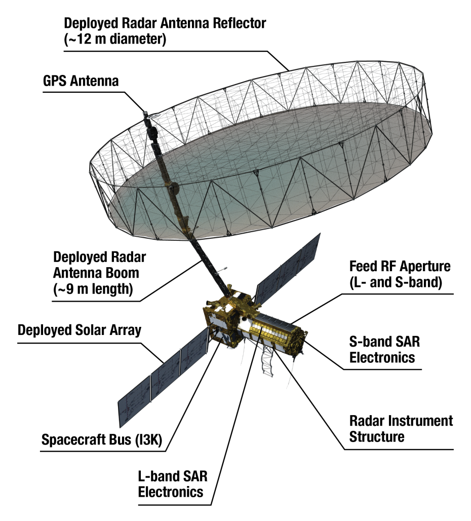
It is a dual-frequency imaging radar satellite weighing 2,800 kilograms and equipped with both L-band and S-band Synthetic Aperture Radar (SAR) instruments.
While ISRO (Indian Space Research Organisation) contributed the S-band radar, the Geosynchronous Satellite Launch Vehicle (GSLV) launch system, and the spacecraft, NASA provided the L-band radar, GPS, a high-capacity solid-state recorder to store data, and a payload data subsystem.
S-band radars function between 2-4 GHz and have a wavelength of 8 to 15 cm. They are difficult to attenuate because of their wavelength and frequency. They can be used for both local and global weather observation because of this.
NISAR Mission
In order to focus the radar signals sent and received by the upward-facing feed on the sensor structure, it features a 39-foot stationary antenna reflector built of a gold-plated wire mesh.
NISAR will create high-resolution photos utilizing SAR. No matter the weather, SAR can gather data day or night because it can penetrate clouds.
For at least three years, NASA will need the L-band radar for its global science operations. The S-band radar would be used by ISRO for a minimum of five years.
L-Band
The Institute of Electrical and Electronics Engineers (IEEE) refers to the radio frequency band between 1 and 2 gigahertz as the L band (GHz). This is at the top end of the ultra-high frequency (UHF) band and the lower end of the microwave spectrum.
S-Band
The Institute of Electrical and Electronics Engineers (IEEE) refers to the microwave band, which covers frequencies between 2 and 4 gigahertz, as the “S-band” (GHz).
As a result, it crosses the normal boundary between the UHF and SHF bands at 3.0 GHz. Several communications satellites, including those used by NASA to interface with the Space Shuttle and the International Space Station, weather radar, surface ship radar, airport surveillance radar for air traffic control, and some satellites used for communications.
Advantages
Earth Science
NISAR will offer a wealth of information and data about changes to the Earth’s surface, natural disasters, and ecological disturbances, advancing our knowledge of Earth’s system processes.
Disaster management
The mission will deliver crucial data to aid in the management of natural disasters like earthquakes, tsunamis, and volcanic eruptions, enabling quicker response times and better risk assessments.
Farm
NISAR data will be utilized to provide information regarding crop growth, soil moisture, and land-use changes in order to improve agricultural management and food security.
Infrastructure Monitoring
The mission will offer information for managing and monitoring infrastructure, such as keeping an eye on deforestation, urbanization, and oil spills.
Climate Change
NISAR will assist in seeing and comprehending the effects of climate change on the terrestrial surface of the planet, such as melting glaciers, rising sea levels, and modifications in carbon storage.
Way ahead
- The Satish Dhawan Space Center is scheduled to launch the three-year NISAR mission in 2024. NISAR will be used by ISRO for many different tasks, such as mapping agricultural areas, monitoring glaciers in the Himalayas, and landslide-prone regions, and observing changes in the shoreline.
- The S-band radar will be used by ISRO for at least five years. For at least three years, NASA will need the L-band radar for its global science operations. Losses caused by calamities must be reduced for our society and economy. To implement effective mitigation and make the most of our resources responsibly and economically, we need to make educated decisions.
- We can decipher other impacts and comprehend processes taking place at depth by measuring movements and other changes on the Earth’s surface. With the aid of NISAR data and scientifically based management and storage of freshwater and energy sources, resources can be used more effectively and sustainably.
- The information from NISAR can assist people in different parts of the world manage natural resources and risks effectively. It can also help scientists better understand the consequences and rate of climate change.
Source:
Daily Current Affairs for UPSC
PLUTUS IAS CURRENT AFFAIRS 10th FEB 2023
Every UPSC aspirant should read current affairs for passing the UPSC examination. They have to analyze all the topics of current affairs and memorize them properly for enhancing the wide range of knowledge on the UPSC syllabus. So, read the best and latest daily current affairs for the UPSC examination from Plutus IAS. Also, collect the weekly, and monthly current affairs for the IAS exam preparation.

No Comments