
02 May Great Nicobar Project : India’s Strategic Leap or Nature’s Silent Loss?
This article covers “Daily Current Affairs”
SYLLABUS MAPPING : GS Paper 2, 3 (Government Policies , Economy, Environment)
FOR PRELIMS : Geography of Indian Islands, Ports of India, Tribes of India etc.
FOR MAINS : “The rights of Particularly Vulnerable Tribal Groups (PVTGs) under the Forest Rights Act, 2006 cannot be overridden by strategic or economic considerations. In light of the Great Nicobar Island Development Project, examine the constitutional and legal safeguards for PVTGs and assess whether they have been adequately upheld.”
CONTEXT: RAHUL GANDHI’S VISIT
- Recently, Rahul Gandhi visited Campbell Bay and met tribal leaders actively opposing the project.
- On April 29, 2026, he walked through forests marked for clearance, calling the project a “crime against natural and tribal heritage.”
- He alleged that 160 sq. km of rainforest would be destroyed primarily to “fulfil one businessman’s fantasies,” referencing Adani Group’s interest in the transshipment port.Gandhi demanded immediate suspension of all clearances and announced he would raise the issue in Parliament.
- His visit drew national attention to a project that had largely been progressing without mainstream scrutiny, shifting the narrative from a “technical policy debate” to a “human rights and ecological crisis.”
WHAT IS THE GREAT NICOBAR PROJECT?
Background
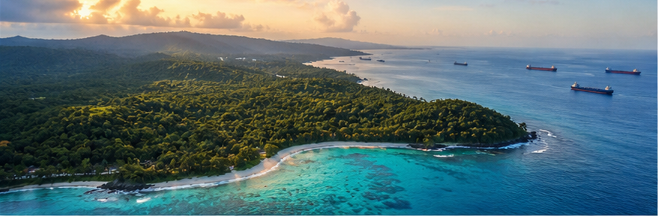
- Great Nicobar Island is India’s southernmost and largest island in the Andaman and Nicobar archipelago.
- It lies approximately 90 km north of Indonesia and is only 40 nautical miles from the busy East-West international shipping route passing through the Strait of Malacca.
- The island currently has a population of around 8,000–9,000 people.
- It is home to Campbell Bay National Park and Galathea National Park, and is a UNESCO Biosphere Reserve.
- The project was conceived by NITI Aayog, with a feasibility report prepared by AECOM India. It is being implemented by the Andaman and Nicobar Islands Integrated Development Corporation (ANIIDCO).
- Total project cost: ₹81,000 crore (revised in 2025), originally ₹75,000 crore (2022 estimate).
The Four Core Infrastructure Pillars
International Container Transshipment Terminal (ICTT) at Galathea Bay
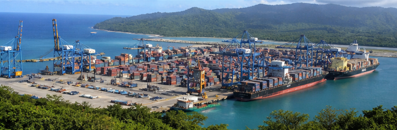
- Capacity: 14.2 million TEU (Twenty-foot Equivalent Units) — making it one of the largest ports in Asia.
- Natural water depth of over 20 metres — ideal for ultra-large container ships without dredging.
- Located close to one of the busiest shipping lanes where 90,000+ merchant ships pass annually, carrying ~30% of global trade.
- Designed to directly compete with Colombo (Sri Lanka), Singapore, and Port Klang (Malaysia) — ports where India currently routes much of its transshipment cargo.
- Phase 1 with 4 million TEU capacity is targeted for completion by 2028.
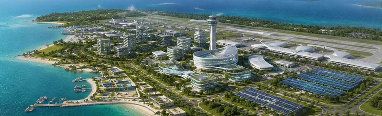
Greenfield International Airport
- Capacity: 4,000 Peak Hour Passengers (PHP).
- Dual-use: Civil aviation + military/strategic use.
- Will enable rapid deployment of naval and air assets in the Indian Ocean Region (IOR).
450 MVA Gas and Solar-Based Power Plant
- To provide reliable energy to the entire development zone.
- Integrates both conventional (gas) and renewable (solar) energy.
- NTPC invited bids for a 5 MW solar power project with battery storage in April 2025.
Greenfield Township
- Spanning 16,610 hectares.
- Designed to eventually house a population of up to 3.5 lakh people — a massive demographic transformation for an island with fewer than 10,000 current residents.
HOW WILL IT BENEFIT INDIA?
Strategic and Defence Significance
- Great Nicobar sits at a chokepoint of the Indian Ocean — directly countering China’s “String of Pearls” strategy (Chinese naval presence in Gwadar, Hambantota, Chittagong, etc.).
- A permanent defence presence will allow India to monitor and secure Sea Lines of Communication (SLOCs).
- The dual-use airport will dramatically improve rapid reaction capability in the Andaman Sea and Bay of Bengal.
- Strengthens India’s “Act East” policy — deepening strategic and economic engagement with Southeast Asia.
- The National Green Tribunal itself noted media reports about the area being in China’s String of Pearls zone, which India’s strategy seeks to counter.
- Will bridge the infrastructure gap in the island and bolster India’s overall presence in the Indo-Pacific.
Economic and Trade Benefits
- India currently loses significant transshipment revenue to foreign ports. Indian cargo is routed through Colombo (Sri Lanka) and Singapore, with India paying fees to competitors.
- The ICTT will help capture a share of global shipping traffic passing through one of the world’s busiest maritime corridors.
- Will reduce India’s dependence on Colombo, Singapore, and Port Klang for transshipment.
- Massive employment generation: direct and indirect jobs in port operations, logistics, airport, township services, and supply chains.
- Stimulates regional economic development across the Andaman & Nicobar Islands.
- Aligns with India’s goal to become a global maritime and logistics hub.
- India’s ports currently lack sufficient deep-water berths for ultra-large container ships. Great Nicobar’s natural depth resolves this without extensive dredging costs.
Connectivity and Tourism
- The international airport will improve air connectivity to the mainland and Southeast Asia.
- Boosts tourism potential for the ecologically rich island chain.
- Improves administrative connectivity to India’s most remote territory.
Geopolitical Messaging
- Signals India’s intent to be a net security provider in the Indian Ocean Region.
- Counters the growing Chinese naval and commercial presence in neighbouring nations.
- Enhances India’s leverage in negotiations with ASEAN nations and the broader Indo-Pacific framework (Quad, etc.).
KEY ISSUES AND CONCERNS
Environmental and Ecological Concerns

- The project area contains one of India’s last intact tropical rainforests — part of a UNESCO Biosphere Reserve.
- 130.75 sq. km of forest will be diverted; up to 7.11 lakh trees felled across three phases.
- Home to rare and endangered species: Leatherback sea turtle (the world’s largest turtle, nests at Galathea Bay), Saltwater crocodile, Nicobar macaque, and numerous endemic species.
- The “Great Nicobar crake” is an undescribed bird species (as of 2026), and Lycodon irwini (a wolf snake) was described only in 2025 — indicating vast unknown biodiversity.
Seismic and Disaster Risk

- Great Nicobar sits atop a major seismic fault line — classified under Seismic Zone V (India’s highest earthquake risk category).
- The 2004 Indian Ocean Tsunami epicentred near here caused the island’s southern tip to sink by ~15 feet. Most coastal settlements were destroyed.
- In July 2025, a geologist warned that a cluster of ongoing smaller earthquakes could signal a volcanic eruption in the Andaman Sea, raising fresh tsunami fears.
- Building a ₹81,000 crore mega-infrastructure project in one of the world’s most seismically active zones raises serious disaster risk concerns.
Tribal and Indigenous Rights Violations

- Shompen Tribe: A Particularly Vulnerable Tribal Group (PVTG) of fewer than 300 individuals, living in near-complete isolation, whose language has not been fully deciphered. They rely entirely on forests for food (wild pigs, honey, fruits).
- Nicobarese: A Scheduled Tribe with greater outside contact but cultural identity tied to ancestral coastal lands — including areas devastated by the 2004 tsunami near Galathea Bay.
- Free, Prior and Informed Consent (FPIC) — mandatory under the Forest Rights Act, 2006 before any forest diversion — was allegedly never properly obtained.
- A petition in the Calcutta High Court by Meena Gupta (former Secretary of Tribal Affairs and Environment) alleged:
- The Forest Rights Certificate (required under FRA) is void.
- A Tribal Welfare officer was nominated to give consent on behalf of the Shompen — but the FRA has no provision for third-party representation of a PVTG.
- Conflict of interest: Both the project proponent (ANIIDCO) and the body that gave consent are under the same administrative leadership (A&N Islands Administration).
- In 2022–2024, approximately 130 sq. km of Tribal Reserve was de-notified for the project.
- The Nicobarese Tribal Council withdrew its No-Objection Certificate (NOC) after claiming they were misled about the project’s actual scale.
- The Tribal Council of Campbell Bay opposes proposed conservation sites on neighbouring islands, citing lack of consultation.
- Survival International submitted a report to the United Nations describing the project as a potential “death sentence for the Shompen” and raised concerns of genocide by development.
Legal and Procedural Concerns
- Environmental Clearance was granted by MoEF&CC’s Expert Appraisal Committee in November 2022 and immediately challenged in courts.
- NGT (February 2026) refused to interfere with the clearance, citing adequate safeguards and strategic importance. Critics argue the Tribunal did not adequately apply the Precautionary Principle (established in Vellore Citizens’ Welfare Forum v. Union of India, 1996).
- Calcutta High Court cases are ongoing; the final hearing was scheduled for the week of March 30, 2026.
- The NGT’s “top-down” monitoring model (High-Powered Committee) is seen as undermining the “bottom-up” democratic rights of Tribal Councils under the FRA.
- Under FRA, 2006, Gram Sabha consent is non-negotiable and cannot be replaced by an HPC consultation.
Marine Ecosystem Threats
- The Galathea Bay port construction threatens coral reef ecosystems and critical sea turtle nesting grounds.
- Poaching of marine resources (corals, sharks, rare fish) by outsiders — already a documented problem — is expected to worsen with increased activity.
- Dredging and maritime traffic will impact the fragile coastal and marine biodiversity of a virtually pristine ecosystem.
WAY FORWARD
Legally Robust Tribal Consent Process
- Implement a genuine Free, Prior and Informed Consent (FPIC) process directly with the Shompen and Nicobarese communities — not through proxies or third-party representatives.
- The Gram Sabha, as mandated under the Forest Rights Act, 2006, must be the primary consent-granting authority — not a High-Powered Committee.
- Any further development must await resolution of pending Calcutta High Court cases.
Independent Environmental Re-Assessment
- Commission a fresh, independent Environmental Impact Assessment by institutions free from government project interest — involving the Zoological Survey of India, Wildlife Institute of India, and international biodiversity experts.
- Apply the Precautionary Principle rigorously: where irreversible ecological harm is plausible (as it clearly is here), the burden of proof must lie with the project proponent.
Phased and Calibrated Development
- Prioritise Phase I components (particularly the transshipment port) that have the highest strategic and economic return, while deferring the township expansion that poses the greatest tribal and demographic risk.
- Redesign the township to limit population influx and protect the cultural and biological integrity of tribal communities.
Seismic and Disaster Resilience Planning
- Mandatory geological and seismic risk assessment by the National Disaster Management Authority (NDMA) and Geological Survey of India before any further construction.
- All infrastructure must be built to Seismic Zone V standards with rigorous tsunami-proofing, given the island’s 2004 history.
Biodiversity and Species Protection
- Fast-track species discovery and documentation before forest clearance begins — hundreds of endemic species may be lost before being named.
- Establish robust in-situ conservation zones with genuine tribal council involvement, not top-down government dictates.
- Ensure compensatory afforestation in ecologically equivalent areas (not dry mainland terrain).
Balancing Strategy with Sustainability
- India’s strategic goals in the Indian Ocean Region are legitimate and necessary — but they need not come at the cost of irreversible ecological and human damage.
- A smaller, more focused port infrastructure at Galathea Bay could achieve India’s transshipment and naval goals without the massive township and associated demographic disruption.
- Adopt a “Build-Monitor-Expand” approach: build Phase I, monitor ecological and social impact rigorously, then decide on subsequent phases based on evidence.
Parliamentary Oversight
- A Joint Parliamentary Committee (JPC) should be constituted to examine the environmental, tribal, strategic, and financial dimensions of the project — ensuring democratic accountability on a decision of this magnitude.
PRELIMS QUESTION
Q. Consider the following statements regarding the Great Nicobar Island Development Project:
- It is being implemented by the Andaman and Nicobar Islands Integrated Development Corporation (ANIIDCO) under the framework conceived by NITI Aayog.
- The International Container Transshipment Terminal (ICTT) at Galathea Bay is designed with a capacity of 14.2 million TEU.
- The Shompen tribe, classified as a Particularly Vulnerable Tribal Group (PVTG), numbers fewer than 300 individuals and inhabits the project area.
- Great Nicobar Island falls under Seismic Zone III of India’s seismic zonation map.
Which of the above statements are correct?
(a) 1, 2 and 3 only
(b) 2 and 4 only
(c) 1, 3 and 4 only
(d) 1, 2, 3 and 4
Answer: (a) — 1, 2 and 3 only
Explanation:
- Statement 1 — Correct: The project was conceived by NITI Aayog and is being implemented through ANIIDCO.
- Statement 2 — Correct: The ICTT at Galathea Bay is designed for a capacity of 14.2 million TEU, making it one of Asia’s largest proposed ports.
- Statement 3 — Correct: The Shompen are indeed a PVTG with fewer than 300 individuals, living in near-complete forest isolation within the project’s footprint.
- Statement 4 — INCORRECT: Great Nicobar Island falls under Seismic Zone V — India’s highest risk category, not Zone III. The 2004 tsunami epicentre was approximately 80 miles away, and an active fault line runs through the region.
MAINS QUESTIONS
“The Great Nicobar Island Development Project represents the classic tension between national strategic imperatives and irreversible ecological loss. Critically examine the environmental concerns associated with the project and suggest a framework that can reconcile development with ecological sustainability.” (15 M)
- India’s Push Beyond E20 Fuel: Reasons, Pitfalls, and the Flex Fuel Future - June 15, 2026
- RBI’s Reviving of FCNR(B) Swap Scheme again in 2026 - June 15, 2026
- Modi’s France Visit & the 52nd G7 Summit - June 13, 2026

No Comments