


09 Jul GEOGRAPHICAL ISSUES BETWEEN INDIA AND CHINA
Geographical Issues Between India and China
The main geographical issues between India and China continue to center on their disputed Himalayan border, but the relationship has evolved since the severe tensions of 2020. In the past two years, both countries have made some progress in dialogue while key disputes remain unresolved.
Here are the major recent geographical issues:
1. The Line of Actual Control (LAC)
The biggest issue is the lack of an agreed boundary along the Line of Actual Control (LAC), which stretches about 3,488 km according to India (China cites a shorter length).
Key friction points include:
-
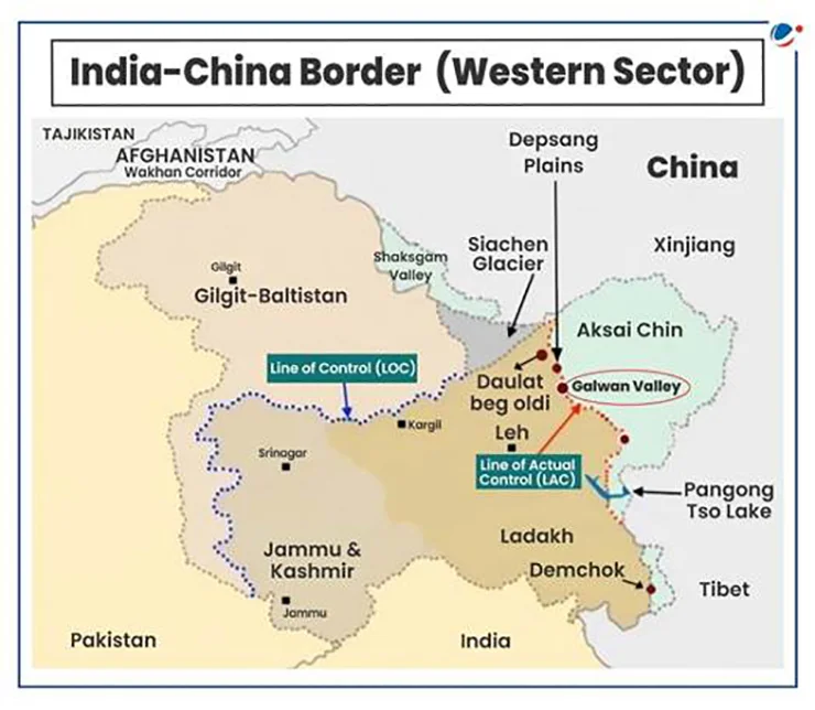
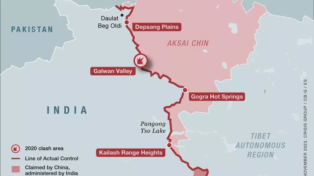
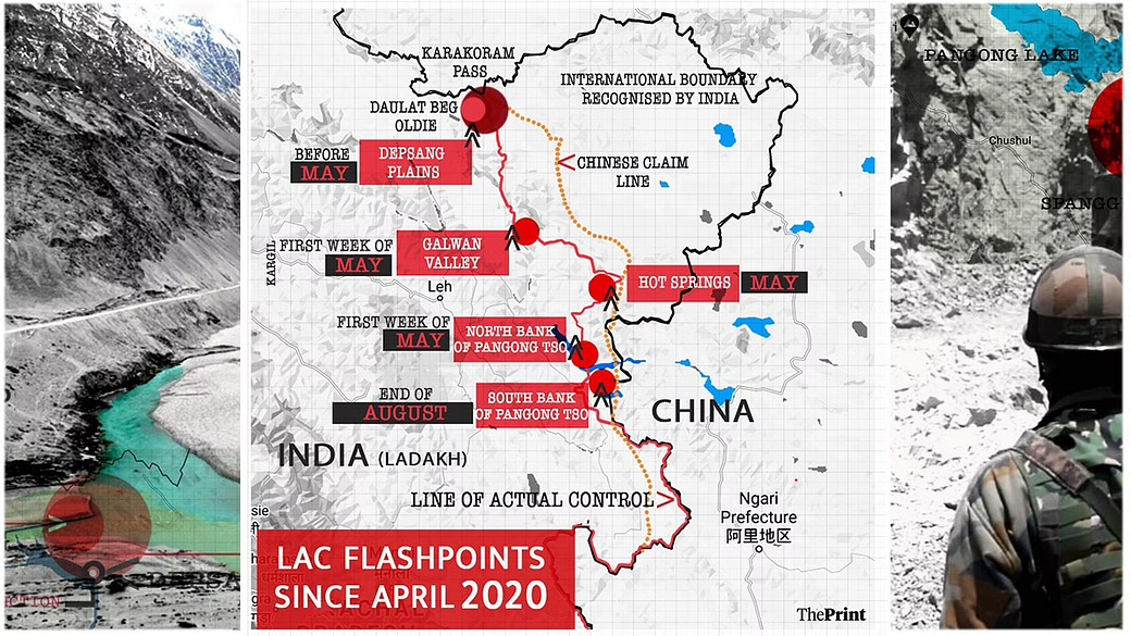
Eastern Ladakh (Western Sector)
-
Arunachal Pradesh (Eastern Sector)
-
Smaller disputed areas in Uttarakhand and Himachal Pradesh
Since both countries interpret the LAC differently, patrols sometimes enter areas claimed by the other side, creating military standoffs.
2. Eastern Ladakh
Although the 2020 military crisis has eased in several locations through disengagement agreements, some issues remain.
Recent developments include:
-
Continued military deployments on both sides.
-
Ongoing diplomatic and military talks.
-
Efforts to reduce tensions while restoring normal border management.
In June 2026, Indian and Chinese officials stated that bilateral relations were gradually normalizing, though border stability remains a prerequisite for broader cooperation.
3. Arunachal Pradesh
China claims almost the entire Indian state of Arunachal Pradesh, referring to it as “South Tibet.”
Recent points of contention include:
-
China issued “standardized” Chinese names for locations in Arunachal Pradesh.
-
India rejected these actions and reaffirmed that Arunachal Pradesh is an integral part of India.
-
Continued infrastructure development by both countries near the border.
This remains one of the most politically sensitive territorial disputes.
4. Aksai Chin
India claims Aksai Chin, while China administers it.
Why it matters:
-
It connects China’s Xinjiang and Tibet regions through a strategic highway.
-
India considers it part of the former princely state of Jammu and Kashmir.
Although there have been no major recent clashes there, it remains a core unresolved territorial dispute.
5. Border Infrastructure Competition
Both countries have accelerated infrastructure construction near the LAC, including:
-
Roads
-
Bridges
-
Airfields
-
Tunnels
-
Military logistics facilities
India has expanded road connectivity in border regions, while China has continued developing transport networks and settlements on its side of the frontier. This infrastructure improves mobility but can also increase the speed at which forces are deployed during crises.
6. Water and River Issues
China is constructing large hydropower projects on the Yarlung Tsangpo, which becomes the Brahmaputra in India.
India’s concerns include:
-
Possible effects on downstream water flow.
-
Flood management.
-
Ecological impacts.
-
Limited transparency over project details.
China has stated that the projects are intended for hydropower generation, but India continues to seek greater information-sharing and consultation.
7. Border Trade
There have also been signs of limited improvement in cross-border engagement.
For example:
-
Border trade through Lipulekh Pass reopened after a six-year suspension.
-
However, practical issues such as customs arrangements and logistics have delayed full resumption of commercial activity.
Current Situation (2026)
The overall picture is mixed:
-
Both governments have resumed high-level diplomatic engagement and describe relations as improving.
-
Military commanders continue to meet to manage tensions along the LAC.
-
The underlying territorial disputes over the border have not been resolved, and both countries continue to maintain significant military presence in sensitive sectors.
In summary, the principal geographical issues are:
-
The unresolved LAC alignment.
-
Territorial claims over Aksai Chin and Arunachal Pradesh.
-
Military deployments and infrastructure development along the border.
-
Concerns over Chinese dam projects on transboundary rivers.
-
Gradual normalization of diplomatic ties despite the continuing border dispute.
India and China share one of the world’s longest disputed borders, known as the Line of Actual Control (LAC). Although both countries have maintained diplomatic dialogue in recent years, several geographical issues continue to affect their bilateral relationship. These disputes mainly involve territorial claims, border security, infrastructure development, and the management of shared rivers.
The most significant issue is the boundary dispute along the LAC, which stretches across the western, middle, and eastern sectors of the Himalayas. Since the exact alignment of the LAC is not mutually agreed upon, soldiers from both countries sometimes patrol overlapping claim areas, leading to tensions and military standoffs. While several rounds of military and diplomatic talks have helped reduce tensions in some areas, the border dispute remains unresolved.
One of the most sensitive regions is Eastern Ladakh, where serious military confrontations occurred in 2020. Although both countries have disengaged from some friction points and continue to hold discussions, they still maintain a strong military presence along the border. Restoring peace and stability in this region remains a priority for both governments.
Another major issue concerns Arunachal Pradesh, which is administered by India but claimed almost entirely by China as “South Tibet.” China has repeatedly issued Chinese names for places in the state and objected to visits by Indian leaders there. India firmly rejects these claims, stating that Arunachal Pradesh is an integral and inseparable part of the country. This disagreement continues to create diplomatic tensions.
The dispute over Aksai Chin also remains unresolved. India considers Aksai Chin part of the Union Territory of Ladakh, while China controls the region and regards it as part of Xinjiang and Tibet. The area is strategically important because it contains a highway connecting these two Chinese regions.
In recent years, both India and China have significantly expanded border infrastructure, including roads, bridges, tunnels, airstrips, and military facilities. These developments improve transportation and defence preparedness but also increase concerns about rapid military mobilization during periods of tension.
Another geographical concern involves the Brahmaputra River, known as the Yarlung Tsangpo in China. China’s construction of large hydropower projects on the upper reaches of the river has raised concerns in India about water security, flood management, and environmental impacts. India has emphasized the importance of transparency and cooperation in managing shared water resources.
In conclusion, despite ongoing diplomatic efforts and gradual improvements in communication, the geographical issues between India and China remain complex. Resolving the border dispute, ensuring peace along the LAC, promoting confidence-building measures, and enhancing cooperation over shared natural resources are essential for maintaining long-term stability and fostering stronger relations between the two neighboring countries.


No Comments