


29 Jul विकसित ग्राम पंचायत योजना: वीबी-जी राम जी अधिनियम 2025 के तहत ग्रामीण विकास
Subject Relevance — Where This Topic Fits
- GS Paper II — Constitutional and Statutory Bodies (Panchayati Raj Institutions) | GS Paper III — Rural Development, Employment Schemes, and Digital Governance
- Prelims: VB-G Ram Ji Act 2025, Vikasit Gram Panchayat Yojana (VGPY), YuktDhara GIS platform, Part VII of the Constitution (Panchayats), Article 243G, Garib Kalyan Rozgar Abhiyaan (Gramin), Participatory Rural Planning, Geospatial planning tools, District Programme Coordinator, Employment Guarantee Scheme (EGS)
- Essay: Role of technology in grassroots governance: A case for GIS-enabled participatory planning in rural India, From welfare to rights: The evolution of employment guarantee schemes in India
Quick Revision: The Vikasit Gram Panchayat Yojana (VGPY) is a legally mandated, GIS-enabled, participatory rural planning framework under the VB-G Ram Ji Act, 2025, requiring Gram Panchayats to prepare development plans that integrate employment guarantees and local priorities, with YuktDhara serving as the technological backbone for scientific planning and monitoring.
Why is this in the news?
The Press Information Bureau (PIB), Ministry of Rural Development, Government of India, issued a press release on 28 July 2026, detailing the operationalisation of the Vikasit Gram Panchayat Yojana (VGPY) under Section 16 of the VB-G Ram Ji Act, 2025. The release outlines the legal mandate for participatory rural planning, the role of GIS-based planning tools like YuktDhara, institutional capacity-building mechanisms, and the financial provisions for semi-skilled workers engaged in the planning process, thereby underscoring the intersection of statutory governance, digital public infrastructure, and rural employment guarantees.
Background
- The Constitution of India, through the 73rd Amendment Act, 1992, established a three-tier Panchayati Raj system to decentralise governance and empower local communities, with Article 243G mandating the devolution of functions and funds to Panchayats for rural development.
- The Garib Kalyan Rozgar Abhiyaan (Gramin), launched in 2020, was a convergence scheme aimed at providing immediate employment and livelihood opportunities in rural areas through 125 days of guaranteed wage employment per household.
- Geospatial technologies, including GIS, have been progressively adopted in India for land-use planning, disaster management, and infrastructure development, with the National Geospatial Policy, 2022, providing a strategic roadmap for their utilisation in governance.
- Capacity-building in rural governance has been a persistent challenge, with the Ministry of Rural Development emphasising the need for cascading training frameworks to ensure effective implementation of centrally sponsored schemes at the grassroots level.
- The YuktDhara platform, developed as part of the Digital India Land Records Modernisation Programme (DILRMP), exemplifies the integration of geospatial data with administrative processes to enhance transparency and efficiency in rural planning.
What is the Vikasit Gram Panchayat Yojana (VGPY)?
- The VGPY is a statutory planning instrument mandated under Section 16 of the VB-G Ram Ji Act, 2025, requiring every Gram Panchayat to prepare a comprehensive development plan through a participatory process involving the Gram Sabha.
- The plan must identify permissible development activities, prioritise them based on local needs, and align with the broader objectives of the Vikas Bharat – Garib Kalyan Rozgar Abhiyaan (Gramin) to ensure employment and livelihood security in rural areas.
- The VGPY is prepared using the YuktDhara GIS-based planning tool, which provides geospatial data, analytical inputs, and visualisation capabilities to support scientific and evidence-based planning at the village level.
- Once prepared, the VGPY is aggregated at the intermediate (Block) and district levels to inform the preparation of Block and District Plans, ensuring vertical integration of rural development strategies.
- The participatory process ensures that local priorities, such as water conservation, rural connectivity, agricultural productivity, and social infrastructure, are reflected in the planning and implementation of development schemes.
- The legal mandate under the VB-G Ram Ji Act, 2025, provides statutory backing to the VGPY, ensuring accountability and resource allocation for its implementation through local governance institutions.
Key Features
| Feature | Significance |
|---|---|
| Participatory Planning Process | Ensures grassroots-level involvement through Gram Sabhas in identifying and prioritising development needs, fostering local ownership and democratic decentralisation. |
| GIS-based Planning Tool (युक्तधारा) | Provides geospatial data and analytical inputs to facilitate scientific, evidence-based planning for rural development interventions. |
| Multi-tier Consolidation | Integrates Village, Intermediate, and District Panchayat plans to align local aspirations with block and district-level development strategies. |
| Capacity Building Framework | Includes cascading training modules, standard operating procedures, and digital resources to enhance technical and administrative competencies at all governance levels. |
| Employment-linked Implementation | Mandates payment to semi-skilled workers (Mates) at state-notified wage rates under the VGPP, linking planning to livelihood generation. |
Why it Matters
Institutional Strengthening
- Reinforces the 73rd Constitutional Amendment Act, 1992, by operationalising participatory planning and decentralised governance in rural India.
- Enhances the role of Panchayati Raj Institutions (PRIs) as primary entities for local development planning and resource mobilisation.
- Promotes convergence between central schemes (e.g., MGNREGS) and local priorities through integrated planning frameworks.
Technological Integration
- Leverages geospatial technology (GIS) to improve accuracy in identifying development gaps and resource allocation.
- Facilitates real-time monitoring and evaluation of rural development projects through digital platforms (युक्तधारा portal).
- Reduces administrative delays by standardising planning processes and documentation.
Employment and Livelihoods
- Links rural planning directly to job creation by mandating wage employment for semi-skilled workers in approved VGPP activities.
- Aligns with the Garib Kalyan Rozgar Abhiyaan’s objective of sustainable livelihood generation in rural areas.
- Ensures transparency in wage disbursement through state-notified rates and digital tracking mechanisms.
Policy Coherence and Governance
- Bridges the gap between national missions (e.g., Developed India – Employment and Livelihood Guarantee Mission) and local governance structures.
- Provides a structured framework for state governments to allocate human resources (e.g., Programme Coordinators, Mates) for effective implementation.
- Promotes accountability through multi-tiered approval and consolidation mechanisms.
Challenges
1. Institutional Capacity Gaps
- Limited technical expertise among PRIs in GIS-based planning and data analysis, necessitating sustained capacity-building efforts.
- Inadequate human resources at the district and block levels to manage complex planning and monitoring processes.
- Variations in state-level administrative frameworks may lead to inconsistent implementation across regions.
UPSC Link: 73rd CAA, 1992 (Panchayati Raj)
2. Digital Divide and Infrastructure
- Rural areas often lack reliable internet connectivity and digital literacy, hindering access to the युक्तधारा portal.
- Dependence on digital tools may exclude marginalised communities, particularly women and SC/ST groups, if not complemented by offline support mechanisms.
- High initial costs for GIS infrastructure and training may strain state budgets.
UPSC Link: Digital India Programme
3. Participation and Inclusion
- Gram Sabhas may face challenges in ensuring equitable representation, particularly for women, SCs, STs, and other marginalised groups.
- Top-down pressures from local elites could distort priority-setting in VGPPs, undermining participatory principles.
- Language barriers and low awareness about planning processes may limit grassroots engagement.
UPSC Link: Article 243D (Reservation in PRIs)
4. Funding and Resource Mobilisation
- Uncertainty in devolution of funds from state governments to PRIs for VGPP implementation may delay or dilute outcomes.
- Over-reliance on centrally sponsored schemes (e.g., MGNREGS) could restrict flexibility in local planning.
- Need for innovative financing models (e.g., public-private partnerships) to sustain long-term rural development.
UPSC Link: Article 280 (Finance Commission)
5. Monitoring and Evaluation
- Lack of standardised metrics for measuring the impact of VGPPs on rural employment and livelihoods.
- Delayed or incomplete consolidation of plans at higher tiers may obscure gaps in implementation.
- Need for real-time data analytics to track progress and address bottlenecks proactively.
UPSC Link: Article 243ZD (District Planning Committee)
Challenges — UPSC Perspective
| Issue | Concern |
|---|---|
| Low Digital Literacy | Exclusion of marginalised groups from planning processes due to lack of access to GIS tools. |
| Elite Capture | Risk of local power structures dominating Gram Sabha discussions and distorting priority-setting. |
| Funding Delays | State governments may underfund VGPP implementation, leading to suboptimal outcomes. |
| Monitoring Gaps | Absence of real-time tracking mechanisms to assess the progress of approved VGPPs. |
| Inter-state Disparities | Variations in administrative capacity and resources across states may lead to uneven implementation. |
| Wage Disparities | State-notified wage rates for Mates may not align with local economic realities, affecting livelihood outcomes. |
Way Forward
- Strengthen institutional capacity of PRIs through targeted training programmes on GIS-based planning and participatory methodologies.
- Ensure equitable access to digital tools by expanding internet connectivity in rural areas and providing offline support for marginalised communities.
- Institutionalise multi-tiered monitoring mechanisms with real-time data analytics to track VGPP implementation and address bottlenecks.
- Promote inclusive participation by mandating gender and social audits in Gram Sabhas and ensuring representation of SC/ST groups.
- Develop flexible funding mechanisms, including convergence with state and central schemes, to ensure sustained resource flows for VGPPs.
- Standardise wage rates for Mates across states to ensure fair compensation and livelihood security for semi-skilled workers.
- Encourage state governments to adopt innovative financing models, such as public-private partnerships, for long-term rural development.
- Establish a national-level task force to oversee the implementation of VGPPs and address inter-state disparities.
UPSC Value Addition
Keywords for Mains Answer-Writing
Developed Gram Panchayat Plan (VGPP) · Viksit Bharat – Garib Kalyan Rozgar Abhiyaan (VBG-RGA) Act, 2025 · Section 16 of VBG-RGA Act, 2025 · Participatory planning process · Gram Sabha · Geographical Information System (GIS)-based YuKtDhara portal · Capacity building in Panchayati Raj Institutions (PRIs) · Gram Panchayat Development Plan (GPDP) · Decentralised planning · District Programme Coordinator · Employment Guarantee Mechanism · Rural employment generation · Panchayat-level resource mapping · Block and District-level integration of plans
Constitutional & Policy Linkages
- Article 243 (Definition of Panchayats)
- Article 243B (Constitution of Panchayats)
- Article 243C (Composition of Panchayats)
- Article 243D (Reservation for Women and SC/STs)
- Article 243G (Functions of Panchayats)
- Article 243ZD (District Planning Committee)
Concept Flow
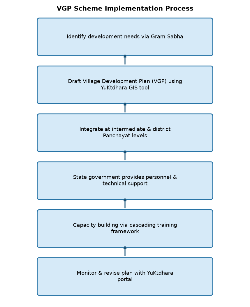
Constitutional mandate (73rd CAA, 1992) → Decentralised governance (PRIs) → Participatory planning (Gram Sabhas) → VG-BG RAMJI Mission, 2025 → Section 16 mandate (VGPP preparation) → GIS-based planning (युक्तधारा tool) → Gram Sabha identifies priorities → Gram Panchayat drafts VGPP → Intermediate/District Panchayats consolidate plans → Capacity building (training modules, digital resources) → State-level resource allocation (human resources, funds) → Implementation (wage employment for Mates) → Monitoring (युक्तधारा portal, real-time analytics) → Outcome: Integrated rural development, livelihood generation, and convergence with national missions
Prelims Practice Questions
Q1. Which of the following statements is/are correct regarding the Developed Gram Panchayat Plan (VGPP) under the Viksit Bharat – Garib Kalyan Rozgar Abhiyaan (VBG-RGA) Act, 2025?
- A. The VGPP is prepared solely by the District Programme Coordinator without any participation from Gram Sabha.
- B. The YuKtDhara portal is a GIS-based tool used for identifying and prioritising permissible works under VGPP.
- C. The VGPP is prepared only at the block level and not at the Gram Panchayat level.
- D. The VGPP is not required to be integrated with higher-level plans such as block or district plans.
Answer: B. The YuKtDhara portal is a GIS-based tool used for identifying and prioritising permissible works under VGPP. — Statement B is correct as the YuKtDhara portal is explicitly described as a GIS-based planning tool for VGPP preparation. Statements A, C, and D are incorrect as the VGPP is prepared through a participatory process involving Gram Sabha, at the Gram Panchayat level, and must be integrated with block and district plans.
Q2. Under the VBG-RGA Act, 2025, which of the following entities is responsible for ensuring the availability of personnel and technical support for the effective implementation of the VGPP?
- A. The Gram Panchayat itself
- B. The State Government
- C. The District Programme Coordinator
- D. The YuKtDhara portal
Answer: B. The State Government — Statement B is correct as the State Government is explicitly tasked with providing personnel and technical support, including the appointment of District Programme Coordinators and Programme Officers, under Section 21 of the VBG-RGA Act, 2025.
Q3. The YuKtDhara portal is primarily designed to assist in which of the following activities related to the VGPP?
- A. Conducting Gram Sabha meetings
- B. Identifying permissible works, prioritising them, and preparing scientific plans using geospatial data
- C. Disbursing wages to Mates under the employment guarantee mechanism
- D. Conducting capacity-building programmes for PRIs
Answer: B. Identifying permissible works, prioritising them, and preparing scientific plans using geospatial data — Statement B is correct as the YuKtDhara portal is described as a GIS-based tool for identifying permissible works, prioritising them, and preparing scientific plans using geospatial data and analytical inputs.
Mains Practice Question
✍ Examine the significance of participatory planning in the preparation of the Developed Gram Panchayat Plan (VGPP) under the Viksit Bharat – Garib Kalyan Rozgar Abhiyaan (VBG-RGA) Act, 2025. How does the YuKtDhara portal enhance the scientific rigour and efficiency of this process? (250 words)
Approach: The answer should highlight the constitutional and statutory basis of participatory planning in India, particularly under the 73rd Constitutional Amendment Act, 1992, and the Panchayati Raj Act. Discuss the role of Gram Sabha in identifying and prioritising permissible works for VGPP preparation. Explain how the YuKtDhara portal, being a GIS-based tool, facilitates data-driven decision-making by providing geospatial information and analytical inputs, thereby ensuring scientific planning. Conclude by linking this process to the broader objectives of rural employment generation and sustainable development under the VBG-RGA Act, 2025.
Source: PIB (Press Information Bureau)
Generated by AanyaAi for educational purpose.

- अगस्त 2026 में खुदरा मुद्रास्फीति 4.82%: सीपीआई एवं खाद्य मुद्रास्फीति के प्रमुख आँकड़े - September 14, 2026
- UPSC Alert: August 2026 CPI Inflation at 4.82% – Key Data for Mains & Prelims - September 14, 2026
- कर्नाटक हाईकोर्ट ने शराब पीकर गाड़ी चलाने वालों पर कसा शिकंजा, मुआवजा 30% घटाया - September 14, 2026

No Comments