


09 Sep Sangam-era water structure found in Kollidam riverbed: UPSC relevance
✎ The Sangam-period brick structure in the Kollidam riverbed is a water regulation system, demonstrating advanced hydraulic engineering in ancient Tamil Nadu.
Subject Relevance — Where This Topic Fits
- GS Paper I — Ancient History | GS Paper I — Art and Culture
- Prelims: Sangam literature, Kallanai Dam, Kollidam River, Water management systems in ancient India, Archaeological survey techniques
- Essay: Ancient Indian engineering and technological advancements
Quick Revision: The Sangam-period brick structure in the Kollidam riverbed is a water regulation system, demonstrating advanced hydraulic engineering in ancient Tamil Nadu.
Why is this in the news?
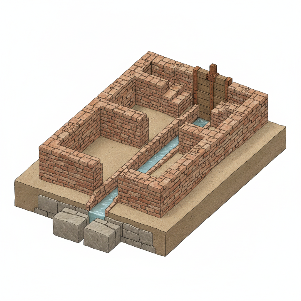
The Tamil Nadu State Department of Archaeology (TNSDA) has identified a brick structure in the Kollidam riverbed near Lalgudi, Tiruchi district, as a Sangam-period water regulation infrastructure. The discovery, made during a survey following water level recession, provides significant archaeological evidence of advanced water management practices during the Sangam era (circa 300 BCE–300 CE). The structure’s design, dimensions, and construction techniques align with known Sangam-era engineering, highlighting the historical sophistication of ancient Tamil society.
Background
- The Sangam period (300 BCE–300 CE) represents a golden age in Tamil Nadu’s history, marked by advancements in literature, art, and engineering.
- The Kollidam River, a distributary of the Kaveri, has been a critical water source for irrigation and settlement since antiquity.
- The Kallanai Dam, one of the oldest functional dams in the world, is located near the site, underscoring the region’s long-standing focus on water conservation.
- Archaeological surveys in Tamil Nadu, such as those at Keeladi, Arikamedu, and Poompuhar, have previously uncovered Sangam-era brick structures, indicating a well-developed understanding of hydraulic engineering.
- The discovery of similar water management structures at Poompuhar further corroborates the existence of systematic irrigation practices during the Sangam period.
What is the Sangam-period water management structure in the Kollidam riverbed?
- The structure is a brick-built water regulation system.
- It comprises two distinct sections, each designed to control water flow: the first section runs west-east for 6 metres before curving northwards for 8.3 metres, while the second section is parallel, running east-west for 6.5 metres and curving northwards for 4.5 metres.
- The bricks used in construction measure approximately 39–43 cm in length, 20–22 cm in width, and 6–7 cm in thickness, consistent with Sangam-era brick dimensions found at sites like Arikamedu and Keeladi.
- The structure’s location in the riverbed and its design suggest it was built to regulate water levels, possibly for agricultural purposes or flood control.
- The study employed sonar imaging and trained divers to document the submerged portions, revealing the full extent of the structure despite partial burial under sand.
- Such brick structures were later superseded by stone anicuts (dams) and modern irrigation systems, reflecting the evolution of water management technologies in India.
- The discovery underscores the advanced engineering capabilities of the Sangam civilization, which integrated hydraulic systems with socio-economic development.
- Further excavations and studies are expected to uncover additional structures, providing deeper insights into ancient Tamil Nadu’s water management practices.
Key Features
| Feature | Significance |
|---|---|
| Period of origin | Attestation to Sangam-period (300 BCE–300 CE) engineering and water management practices, corroborating literary and inscriptional sources. |
| Construction material | Brick dimensions (39–43 cm × 20–22 cm × 6–7 cm) align with Sangam-era brick typologies from Arikamedu, Keeladi, Mangulam, and Poompuhar. |
| Structural design | Two-section layout with curved alignments suggests a functional design for water regulation, comparable to a check dam or diversion structure. |
| Location context | Proximity to Kallanai dam underscores the continuity of water management systems in the Kaveri delta region since antiquity. |
| Archaeological methodology | Use of sonar and trained divers for underwater documentation demonstrates modern archaeological techniques applied to submerged heritage. |
Why it Matters
Historical and Cultural
- Provides material evidence for the existence of advanced water management systems during the Sangam period, supporting references in Sangam literature and inscriptions.
- Demonstrates the technological continuity of hydraulic engineering from the Sangam era to the later Chola-period anicuts, including the Kallanai dam.
- Enhances understanding of ancient Tamilakam’s socio-economic structures, particularly agricultural and settlement patterns linked to riverine systems.
Economic
- Reinforces the historical basis for Tamil Nadu’s enduring agricultural prosperity, rooted in sophisticated water conservation and distribution systems.
- Supports the narrative of the Kaveri delta as a cradle of early hydraulic civilization, influencing regional economic stability and trade networks.
Scientific and Technological
- Illustrates the application of empirical engineering principles in ancient water regulation, predating modern hydrological science by millennia.
- Highlights the adaptability of brick construction techniques to riverine environments, a precursor to later stone-based anicuts.
Policy and Governance
- Underscores the importance of integrating archaeological discoveries into heritage conservation and water resource management policies.
- Emphasizes the need for systematic documentation and protection of submerged cultural heritage to preserve India’s tangible history.
Challenges
1. Submerged Heritage Conservation
- Risk of structural damage or loss due to seasonal river flow variations and anthropogenic activities such as sand mining.
- Challenges in long-term preservation without disrupting the natural hydrological balance of the river.
- Requirement for interdisciplinary collaboration among archaeologists, hydrologists, and conservationists to develop sustainable protection measures.
UPSC Link: GS I: Ancient History
2. Archaeological Documentation Gaps
- Limited visibility of submerged structures necessitates advanced technologies (e.g., sonar, LiDAR) for comprehensive mapping.
- Need for systematic underwater archaeological surveys to identify and document similar structures across river systems in Tamil Nadu.
- Insufficient funding and institutional capacity for large-scale explorations in submerged contexts.
UPSC Link: GS I: Archaeology
3. Climate Change and River Dynamics
- Increased frequency of extreme weather events may accelerate erosion or burial of submerged structures, complicating preservation efforts.
- Changing river courses due to sedimentation and human interventions (e.g., dams, barrages) threaten the structural integrity of ancient systems.
- Urgent need for climate-resilient heritage management strategies to mitigate risks posed by environmental degradation.
UPSC Link: GS III: Disaster Management
4. Public Awareness and Stakeholder Engagement
- Lack of awareness among local communities about the historical significance of such structures may lead to unintentional damage.
- Need for community-based heritage conservation programs to foster a sense of ownership and participation.
- Role of educational institutions in integrating archaeological discoveries into curricula to enhance historical consciousness.
UPSC Link: GS II: Governance
Challenges — UPSC Perspective
| Issue | Concern |
|---|---|
| Seasonal exposure | Temporary visibility of structures during low water levels complicates sustained documentation and conservation. |
| Technological dependency | Advanced survey tools (sonar, divers) are resource-intensive, limiting accessibility for smaller institutions. |
| Regulatory lacunae | Absence of specific guidelines for the protection of submerged cultural heritage under existing antiquities laws. |
| Interdisciplinary gaps | Limited coordination between archaeology, hydrology, and civil engineering hinders holistic conservation planning. |
| Funding constraints | Insufficient budgetary allocations for underwater archaeology and heritage conservation projects. |
| Climate vulnerabilities | Increased sedimentation and erosion due to climate change threaten structural stability and visibility. |
Way Forward
- Conduct systematic underwater archaeological surveys in the Kollidam and other river systems to identify and document similar Sangam-period structures.
- Develop a national protocol for the protection and conservation of submerged cultural heritage, integrating modern technologies with traditional knowledge.
- Establish a dedicated fund under the Archaeological Survey of India (ASI) or state departments for underwater heritage projects.
- Promote interdisciplinary research by collaborating with institutions like the Indian Institute of Technology (IIT) Madras and the National Institute of Oceanography (NIO) for hydrological and structural analysis.
- Integrate findings from such discoveries into school and university curricula to enhance historical and scientific awareness among students.
- Engage local communities through awareness campaigns and participatory conservation initiatives to ensure grassroots-level protection.
- Strengthen legal frameworks by amending the Ancient Monuments and Archaeological Sites and Remains Act, 1958, to include provisions for submerged heritage.
- Leverage remote sensing and AI-driven tools for predictive modeling of riverbed changes to anticipate and mitigate risks to ancient structures.
UPSC Value Addition
Keywords for Mains Answer-Writing
Sangam period · Kollidam river · water management structures · Kallanai dam · Kurampu · ancient irrigation systems · Tamil Nadu Archaeology Department · brick structures in riverbeds · Sangam-era hydraulic engineering · check dams in ancient India
Concept Flow
Sangam-period hydraulic engineering → Construction of brick-based water regulation structures → Discovery of submerged structure in Kollidam riverbed → Archaeological and technological documentation → Linkage to Kallanai dam and Kurampu traditions → Insights into ancient Tamilakam’s socio-economic systems → Implications for modern water resource management and heritage conservation.
Prelims Practice Questions
Q1. Consider the following statements regarding the brick structure recently discovered in the Kollidam riverbed:
1. The structure is attributed to the Sangam period based on brick dimensions and construction technique.
2. It is located approximately 100 metres from the southern bank of the Kollidam river.
3. The structure comprises two parallel sections, each running east to west before curving northwards.
4. The bricks used measure between 39 cm to 43 cm in length, 20 cm to 22 cm in width, and 6 cm to 7 cm in thickness.
How many of the above statements are correct?
- Only one
- Only two
- Only three
- All
Answer: All — Statements 1, 3, and 4 are correct. Statement 2 is incorrect as the structure is located about 100 metres from the northern bank, not the southern bank.
Q2. Assertion (A): The brick structure discovered in the Kollidam riverbed is comparable to a check dam.
Reason (R): The structure is designed for water management and regulation, as indicated by its design, dimensions, and location in the riverbed.
Options:
A. Both A and R are true, and R is the correct explanation of A.
B. Both A and R are true, but R is not the correct explanation of A.
C. A is true, but R is false.
D. A is false, but R is true.
- A
- B
- C
- D
Answer: B — Both the assertion and reason are true. The structure’s design and location confirm its use for water management, making it comparable to a check dam (Kurampu).
Mains Practice Question
✍ The discovery of a Sangam-period brick structure in the Kollidam riverbed underscores the advanced hydraulic engineering capabilities of ancient Tamil society. Critically examine the significance of such water management systems in the context of the Sangam period and their relevance to contemporary water resource management in India. (15 Marks)
Approach: MODEL-ANSWER SKELETON:
1. **Historical Context**: Briefly describe the Sangam period (300 BCE–300 CE) and its socio-economic reliance on agriculture and water management.
2. **Technological Advancements**: Highlight the engineering sophistication evident in the brick structure (e.g., dimensions, construction technique, and design comparable to check dams like the Kurampu).
3. **Comparative Analysis**: Compare ancient systems (e.g., Kallanai dam, Poompuhar structures) with modern water management techniques in India, focusing on sustainability and adaptive strategies.
4. **Relevance to Contemporary Issues**: Discuss how ancient practices can inform modern challenges such as water scarcity, climate resilience, and sustainable irrigation in India.
5. **Critique and Limitations**: Acknowledge constraints in applying historical solutions directly to contemporary contexts (e.g., scale, material availability, and technological advancements).
6. **Conclusion**: Summarise the enduring value of studying ancient water systems for policy and sustainable development.
Source: The Hindu
Generated by AanyaAi for educational purpose.
Related guides on our sites
- UPSC History optional
- Is history a good optional for upsc exam
- Best history optional teacher for UPSC
- How to prepare for GS paper 1 for UPSC CSE mains exam

- Gurugram’s groundwater extraction exceeds limit by 212%; HC seeks ban - October 4, 2026
- स्वतंत्रता सेनानी श्यामजी कृष्ण वर्मा की जन्म जयंती पर पीएम का श्रद्धांजलि - October 4, 2026
- KWML’s Feasibility Reports for Water Metro in 18 Cities: UPSC & PCS Insights - October 3, 2026

No Comments