23 Mar Zealandia
Zealandia
This article covers “Daily current events “and the topic is about ‘Zealandia’ which is in the news, it covers “Geographical Features & Their Location” In GS-1, the following content has relevance for UPSC.
For Prelims: Zealandia
For Mains: GS-1, Geographical Features & Their Location
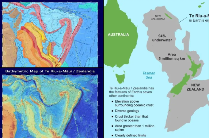
Why in the news: After 375 years of discussion and exploration, scientists have officially proven the presence of Zealandia, also known as Te Riu-a-Mui. Zealandia is now officially designated as the world’s eighth continent.
What defines a continent
- A continent is defined by geologists as a large geographical mass that includes both dry land and continental shelf off the coast.
- A continent is formed by continental crust, which is composed of igneous, metamorphic, and sedimentary materials.
- Basalt comprises the oceanic crust, which is thinner and denser than the continental crust.
- A continent should also have considerable elevation zones in comparison to the surrounding seabed.
- A continent has no minimum size requirement.

Zealandia
How Zealandia fits in the definition
- The islands of New Caledonia to the north, the North, South, and Stewart Islands to the south, the Auckland Islands and Campbell Island to the south, and the Chatham Islands to the west form a continuous span of continental crust.
- The continental crust of Zealandia is physically distinct from the continental crust of Australia.
- This place is likewise relatively high, reaching nearly 3,000 meters above the surrounding oceanic crust.
About Zealandia
Origin
-
- Around 500 million years ago, it was part of an ancient supercontinent called Gondwana, which also contained Western Antarctica and Eastern Australia.
- Zealandia began to separate from Gondwana approximately 105 million years ago.
- It progressively fell beneath the seas, with over 94% of the continent lying submerged for millennia.
- A Dutch businessman and sailor, Abel Tasman Tasman, first discovered Zealandia in 1642.
Location
-
- Zealandia is a long, narrow microcontinent mostly submerged in the South Pacific Ocean.
What is a microcontinent?
-
- A microcontinent is a landmass that has separated from a larger continent.
- Zealandia separated from Antarctica approximately 100 million years ago, and subsequently from Australia approximately 80 million years ago.
Size
-
- This continent covers around 1.89 million square miles.
- Zealandia is roughly half the size of Australia, although just 7% of its land area is above sea level.
What does it consist of
-
- The majority of that terrestrial land is made up of New Zealand’s two big islands, the North and South Islands.
- Zealandia also includes Stewart Island, which is located close south of the South Island, as well as other smaller islets.
- The northern extremity of Zealandia comprises the French-governed islands of New Caledonia.
Climate
-
- Zealandia has a usually pleasant, temperate climate.
- The tropical climate of New Caledonia is more similar to that of Oceania and the South Pacific.
Topography
-
- Its larger islands have glaciers, the most notable of which is Tasman Glacier on the South Island.
- Several fjords and valleys were also formed by glacial activity during the last ice age.
Volcanic Activity
-
- Zealandia is a highly active tectonic area.
- A portion of the microcontinent is located on the Australian plate, while the remainder is located on the Pacific plate.
- The Taupo Volcanic Zone on the North Island is the largest of six major zones with active volcanoes.
- Because of the geothermal activity induced by the contact of the Australian and Pacific plates, This place is home to several natural geysers and hot springs.
- The North Island is dominated by the North Island Volcanic Plateau, whereas the South Island is dominated by the Southern Alps.
- Both mountain ranges are gradually rising due to a process known as tectonic uplift.
- Tectonic uplift is the geologic uplift of the Earth’s surface caused by plate tectonics.
Underwater Zealandia
-
- Mineral riches abound in Zealandia’s submerged region.
- The government of New Zealand strictly regulates undersea mining operations.
- Zealandia, a microcontinent, contributes to the determination of New Zealand’s Exclusive Economic Zone (EEZ).
- Without the approval of another organization, a country may utilize any natural resources, such as oil or fish, in its EEZ.
- The EEZ of New Zealand is approximately 4.3 million square kilometers in size, which is more than 15 times the amount of land above ground.
- There are also numerous natural gas fields distributed around it.
- The largest natural gas field in the Tasman Sea is the Maui field.
Source
Daily Current Affairs for UPSC
Daily Current affairs reflect the overall latest news which is happening in the national and international worlds. The aspirants get all the latest news and pieces of information by reading daily current affairs for the UPSC examination. Here, Plutus IAS provides the best and latest daily current affairs for the UPSC examination. Also, get weekly and monthly current affairs for the IAS exam preparation.


No Comments