04 Oct Arunachal Pradesh denies, Dibang multipurpose project
Arunachal Pradesh denies Dibang multipurpose project
The article talks about how Dibang multipurpose project impacts the Environmental ecology and climate change of India.
Prelim: Issues on Environmental ecology, climate change, and biodiversity
Mains: GS III: Conservation, environmental degradation, and pollution, environmental impact assessment.
Why in headlines:
The National Green Tribunal (NGT) dissolve the case it took up suo motu on the grant of forest clearance for the 3000-MW Dibang hydel project without encountering the preconditions of declaring a national park.
Dibang Multipurpose project

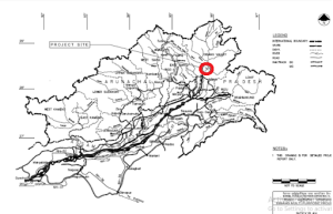
Pic: Dibang multipurpose project
- It is located on river Dibang. In the lower Dibang Valley district of Arunachal Pradesh.
- It is expected that the project will generate 2880 MW(12x240MW) power to produce 11223MU of energy in a 90% dependable year.
- This is India’s largest ever Hydro Electric Project
- The height of the dam is 278 Metres and will be the highest dam in India once it will be completed
- It has been estimated by the government that the project will take nine years to complete
- The dam will be a type of concrete gravity dam
- Dibang River is one of the prime tributaries of the Brahmaputra,
- It makes its way from the northeastern states of India, Arunachal Pradesh and Assam.
- The River originates near Keya pass on the Indo-Chinese border in the Upper Dibang Valley district of Arunachal Pradesh.
- The drainage basin of the river within Arunachal Pradesh covers the districts of Upper Dibang Valley and Lower Dibang Valley
- The demographic area type of the Dibang River Valley is Hydrographic
- The river merges with the Luhit river and flows across the northern side of the Saikhowa Reserve forest
Why this dam can turn into a disaster?
- Due to the unique and compounded geological ecosystem, weather and climate condition, the region of the dam is a high mountain watershed prone to the natural disaster
Few probable risks:
- Seismic hazards
- Glacial hazards like glacial lake outburst floods
- Flooding due to extreme precipitation events
- Landslides
Seismic Risk:
- This region lies in the tectonically active areas of the Eurasian plate that why the region is geologically unstable.
- The Indian plate is still pushing against the Eurasian plate, consequently, the Himalayans are still rising and so they the unstable
- Since the 18 century, 34 earthquakes have been recorded in the Dibang Valley district.
Change in climate:
- The rivers on which the two mega dams are proposed to be constructed are situated just 80 km from the closest glacier.
- The Dibang watershed has around 350 glacial lakes with a cumulative area of 50 square km.
- These glaciers can lose mass and retreat due to climate change.
- One of the effects of glacial thinning is the appearance of lakes on the surface of glaciers (supraglacial lakes).
- Glacier lake outburst floods can be a hazardous result of it
Floods due to high precipitation:
- Supraglacial lakes have already formed and ice chunks broke off glaciers.
- The capacity for the generation of electricity will be impacted by the glacial melt due to climate change
- The expected Dibang river summer glacial melt will be likely replaced by far less expected rainfall events and snow-melt runoffs.
It has been predicted that these glaciers will lose up to 40% of their recent volume by 2030 and 60% by 2050.
Risk of land Slide
- The rate of growth in landslide activity is expected to be significant over areas covered by current glaciers.
- Cases of heavy rainfall will increase with climate change and consequently, the cases of landslides will also increase.
Forest Advisory Committee (FAC)
- It is constituted by the Forest Conservation Act 1980.
- It is a statutory body.
- It is an advisory body
- Ministry of Environment, Forests & Climate Change (MoEF&CC) is its regulatory body.
- It checks the cases on the diversion of forest areas for non-forest uses such as mining, industrial projects, townships, and councils the government on the issues of granting forest clearances
Environmental Impact Assessment (EIA)
- This is a decision support tool for evaluating the probable environmental impacts of a proposed project or development.
- It provides information on the potential implications of projects to those responsible for the decision.
- The objective of an Environmental Impact Assessment is to check the potential ecological, socioeconomic, and wellness outcomes of any project.
Importance of it
- Facilitates sustainable development
- In modern times human activities like rapid industrialization mass production and the cleaning of the forest have put immense pressure on the natural environment.
- The tools like EIA assists to balance the requirement of economical growth along with the importance sustainability concept.
Mitigating the Negative impact and informed decision making
- It helps to check the negative impact of various development projects.
- It enables monitoring programs to be made to access subsequent impacts and give data on which managers can take informed decisions to eliminate environmental damage.
- Baking cost-effectiveness
- EIA helps in picking and forming projects, programs, or plans with long-term viability and hence improves cost-effectiveness
Sources
Daily Current Affairs for UPSC
It is very crucial for any UPSC aspirant to read daily current affairs for UPSC examination. Without reading new and updated current affairs, None of the examinees can crack their competitive examination. So every candidate who is preparing for any competitive examination should read daily read current affairs in English. It is not only enhancing your general knowledge but also increases your communication skill.
Here, PlutusIAS provides the best daily current affairs for UPSC examination. You get all important current affairs from our site. So try to habituate to reading today current affairs for UPSC examination from us.


No Comments