
23 Aug Earth Observation Satellite EOS-08
This article covers “Daily Current Affairs” and topic details of the Earth Observation Satellite EOS-08 and Small Satellite Launch Vehicle.
Syllabus mapping:
GS-3: Science and Technology: Recent development in the space sector.
For Prelims:
What is an Earth Observation Satellite? What are SSLV, and EOS-08?
For Mains:
What is the application of earth observation satellites, and what types of vehicles and their usage?
What is EOS-08 and its application in various fields?
Why in the news?
The Indian Space Research Organisation (ISRO) achieved a significant milestone by successfully placing the Earth Observation Satellite EOS-08 and SR-O DEMOSAT into their intended orbits. The launch took at the Satish Dhawan Space Centre, located approximately 135 km east of Chennai. The mission involved the Small Satellite Launch Vehicle (SSLV) in its third and final developmental flight, SSLV-D3. This flight carried the Earth Observation Satellite EOS-08, developed to enhance ISRO’s capabilities in microsatellite design and payload instrumentation.
Earth Observation satellite vs Communication satellite:
Earth Observation Satellites (EOS)
Purpose: EOS are designed to observe and collect data about the Earth’s surface, atmosphere, and oceans. They provide critical information for environmental monitoring, disaster management, and scientific research.
Types of Data:
Imaging: Captures high-resolution images of the Earth in various wavelengths (visible, infrared, etc.).
Environmental Monitoring: Tracks changes in land use, vegetation, weather patterns, and natural resources.
Disaster Management: Provides data for tracking and assessing natural disasters like floods, wildfires, and earthquakes.
Scientific Research: Supports studies related to climate change, atmospheric conditions, and geological processes.
Typical Payloads:
Optical Imaging Sensors: Capture visible and infrared images.
Radar Sensors: Measure surface characteristics and can operate in all weather conditions.
Spectrometers: Analyze various properties of Earth’s atmosphere and surface.
Orbit: Typically placed in Low Earth Orbit (LEO) to provide detailed and frequent observations.
Examples:
LandSat Series: Provides detailed imagery for land use and environmental studies.
EOS 08 was launched by the ISRO.
Copernicus Sentinel Satellites: Monitors the environment and provides data for climate change and disaster management.
MODIS (Moderate Resolution Imaging Spectroradiometer): Observes and monitors the Earth’s surface and atmosphere.
Communication Satellites
Purpose: Communication satellites are used to relay signals for telecommunications, broadcasting, and data transfer. They play a crucial role in enabling global communications and media broadcasting.
Types of Services Provided:
Telecommunications: Supports voice, video, and data communications for telephone networks, internet services, and private communication networks.
Broadcasting: Delivers television and radio broadcasts to a wide audience.
Data Relay: Transfers data between ground stations and other satellites.
Typical Payloads:
Transponders: Receive, amplify, and retransmit signals.
Antennas: Direct signals to and from specific areas on Earth.
Communication Processors: Handle data processing and routing.
Orbit: Often placed in a Geostationary Orbit (GEO) to maintain a fixed position relative to the Earth’s surface, providing continuous coverage to specific regions.
Examples:
Intelsat Satellites: Provide global telecommunications and broadcasting services.
SES Satellites: Offer a range of communication services, including internet and television broadcasting.
Iridium Satellites: Enable global satellite phone services.
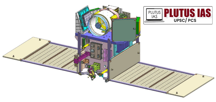
EOS 8 Satellite:
Basic details:
Name: EOS-08
Launch Vehicle: Small Satellite Launch Vehicle (SSLV)-D3
Orbit: Circular Low Earth Orbit (LEO) at 475 km altitude
Payloads
1. Electro-Optical Infrared Payload (EOIR):
Purpose: Captures images in Mid-Wave IR (MIR) and Long-Wave IR (LWIR) bands.
Applications: Includes satellite-based surveillance, disaster monitoring, environmental and industrial monitoring, fire detection, volcanic activity observation, and power plant disaster management.
2. Global Navigation Satellite System-Reflectometry Payload (GNSS-R):
Purpose: Uses GNSS reflectometry for remote sensing.
Applications: Ocean surface wind analysis, soil moisture assessment, cryosphere studies (especially over the Himalayas), flood detection, and inland waterbody monitoring.
3. SiC UV Dosimeter:
Purpose: Monitors UV irradiance and acts as a gamma radiation alarm sensor.
Application: Primarily for monitoring the viewport of the Crew Module in the Gaganyaan Mission.
Satellite Design and Technology
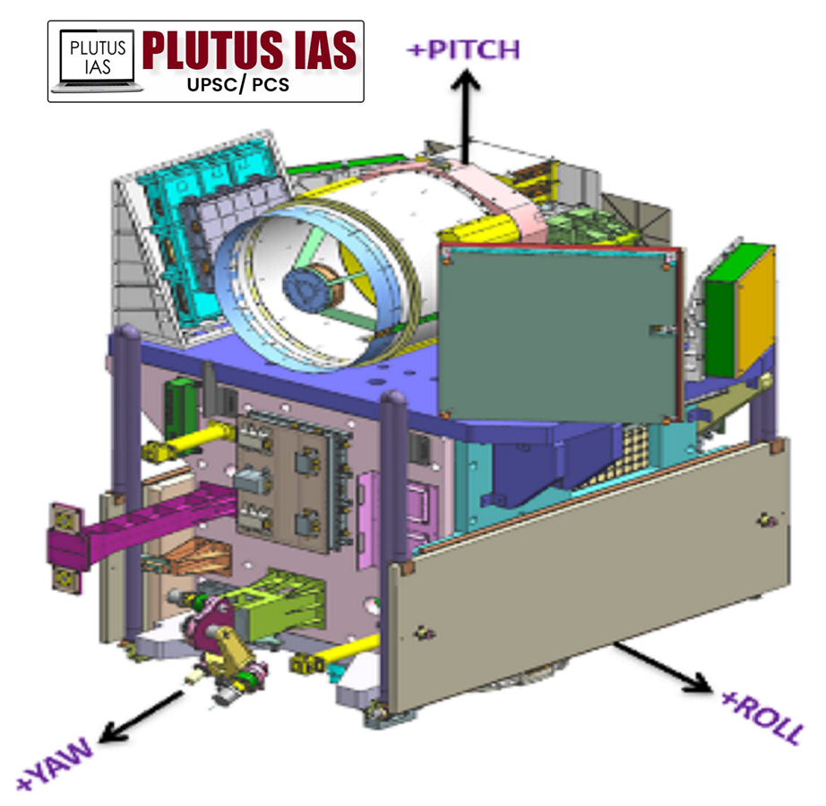
Key Systems:
Integrated Avionics System (CBSP Package): Combines communication, baseband, storage, and positioning functions into a single unit with cold redundancy and supports up to 400 GB of data storage.
Antennas:
Miniaturized Antenna Pointing Mechanisms: Rotational speed of 6 degrees/second with ±1 degree pointing accuracy.
Phased Array Antenna: For enhanced communication capabilities.
Solar Panels: Flexible solar panels with foldable substrate and structural components like GFRP tube and CFRP honeycomb panels for improved power generation and structural integrity.
Thermal Management: Utilizes high thermal conductivity materials such as pyrolytic graphite sheet diffusers (350 W/mK) and other advanced thermal management materials.
Data Transmission: X-band data transmission with pulse shaping and Frequency Compensated Modulation (FCM).
Battery Management System: SSTCR-based charging and bus regulation with sequential inclusion/exclusion of strings at 6 Hz.
TM-TC System: Dual modes including CDMA and Direct PSK with miniaturized microstrip filters.
Innovative Assembly Techniques: Hinge-based fixture for integrating housekeeping panels, reducing AIT phase duration.
Mission Innovations
Indigenization: Incorporates domestic solar cell fabrication and Nano-Star Sensors for microsat applications.
Vibration Control: Reaction wheel isolators to reduce vibrations.
Single Antenna Interface: For TTC and SPS applications.
Auto-Launch Pad Initialization: Enhanced mission management through automation.
The objectives of the SSLV-D3-EOS-08 mission
1. Design and Development of Microsatellite: To design and develop a microsatellite using the Microsat/IMS-1 bus. This involves advancing the technology and capabilities associated with microsatellite systems.
2. Payload Instrumentation: To create and integrate payload instruments compatible with the microsatellite bus. This includes developing and testing various payloads to enhance the satellite’s functionality and application.
3. Advanced Remote Sensing Technologies: To demonstrate and validate advanced remote sensing technologies such as GNSS-R-Based Remote Sensing: Utilizing Global Navigation Satellite System-Reflectometry for applications like ocean surface wind analysis, soil moisture assessment, cryosphere studies, flood detection, and inland waterbody monitoring.
4. Radiation Monitoring: To monitor UV irradiance and gamma radiation as part of the Gaganyaan Mission’s Crew Module, specifically through the SiC UV Dosimeter, which serves as a high-dose alarm sensor.
5. Earth Observation Capabilities: To enhance the ability to conduct Earth observation through various payloads on the EOS-08 satellite, which will support:
A. Satellite-Based Surveillance: Providing images for monitoring and analyzing Earth’s surface.
B. Disaster Monitoring: Detecting and assessing natural and man-made disasters.
C. Environmental Monitoring: Tracking changes in the environment and natural resources.
D. Fire Detection and Volcanic Activity Observation: Identifying and monitoring fires and volcanic activities.
E. Industrial and Power Plant Disaster Monitoring: Observing potential industrial or power plant incidents.
Small Satellite Launch Vehicle (SSLV):
Configuration and Dimensions:
Diameter: 2 meters
Length: 34 meters
Lift-off Mass: Approximately 120 tonnes
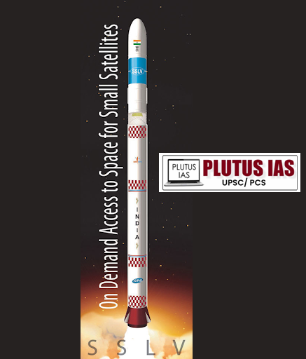
Stages: The SSLV is designed with three solid propulsion stages and a liquid propulsion-based Velocity Trimming Module (VTM) as the terminal stage.
Stage Specifications:
Stage 1 (SS1): Fuel Type: HTPB-based solid propellant
Stage 2 (SS2): Fuel Type: HTPB-based solid propellant
Stage 3 (SS3): Fuel Type: HTPB-based solid propellant
Velocity Trimming Module (VTM): Fuel Type: MMH + MON-3 (liquid)
Payload Capability:
Single Satellite: Capable of launching a satellite with a mass of up to 500 kg into a 500 km planar orbit.
Multiple Satellites: Capable of deploying multiple satellites ranging from 10 kg to 300 kg into a 500 km planar orbit.
Key Features:
Cost-Effective: Designed for low-cost launches, making it accessible for various missions.
Short Turnaround Time: Efficient design allows for rapid preparation and launch, meeting tight schedules.
Flexible Payload Accommodations: Can handle single or multiple satellite deployments, offering versatility for different mission needs.
Launch on Demand: Capable of launching on short notice, providing flexibility in mission planning.
Minimal Infrastructure Requirements: Requires less launch infrastructure compared to larger rockets, reducing overall mission costs.
The SSLV is a highly adaptable and efficient solution for deploying small satellites, combining solid propulsion reliability with precise liquid propulsion for terminal stage adjustments. Its design emphasizes cost-effectiveness, flexibility, and minimal infrastructure needs, catering to the evolving demands of small satellite missions.
Prelims question:
Q. Consider the following statements:
Statement-I:
In India, August 23 is celebrated annually as National Space Day.
Statement-II:
On August 23, 2023, ISRO successfully launched the Chandrayaan-3 mission, aimed at landing on the Moon’s Nothern pole.
Which one of the following is correct in respect of the above statements?
(a) Both Statement-I and Statement-II are correct and Statement-II is the correct explanation for Statement-I
(b) Both Statement-I and Statement-II are correct and Statement-II is not the correct explanation for Statement-I
(c) Statement I is correct but Statement-II is incorrect
(d) Statement-I is incorrect but Statement-II is correct
ANSWER: C
Mains Question:
The Space sector is one of the top priorities of India to demonstrate advancement in the science and technology field. In this regard discuss the various initiatives taken by the government in the space sector and what are the issues India’s Space sector is facing, and suggest the way forward.
(250 words 15 marks)
No Comments