
23 Jul Earthquakes and Tsunamis
Earthquakes and Tsunamis – UPSC Geography Optional Notes
Earthquakes and tsunamis are significant geophysical phenomena that play a critical role in shaping the earth’s surface. As per the UPSC CSE Geography Optional Paper 1 syllabus, understanding these concepts is essential to grasp the dynamic nature of Earth’s processes. These events not only lead to massive physical transformations but also pose significant hazards to life and property.
1. Earthquakes: Meaning and Causes
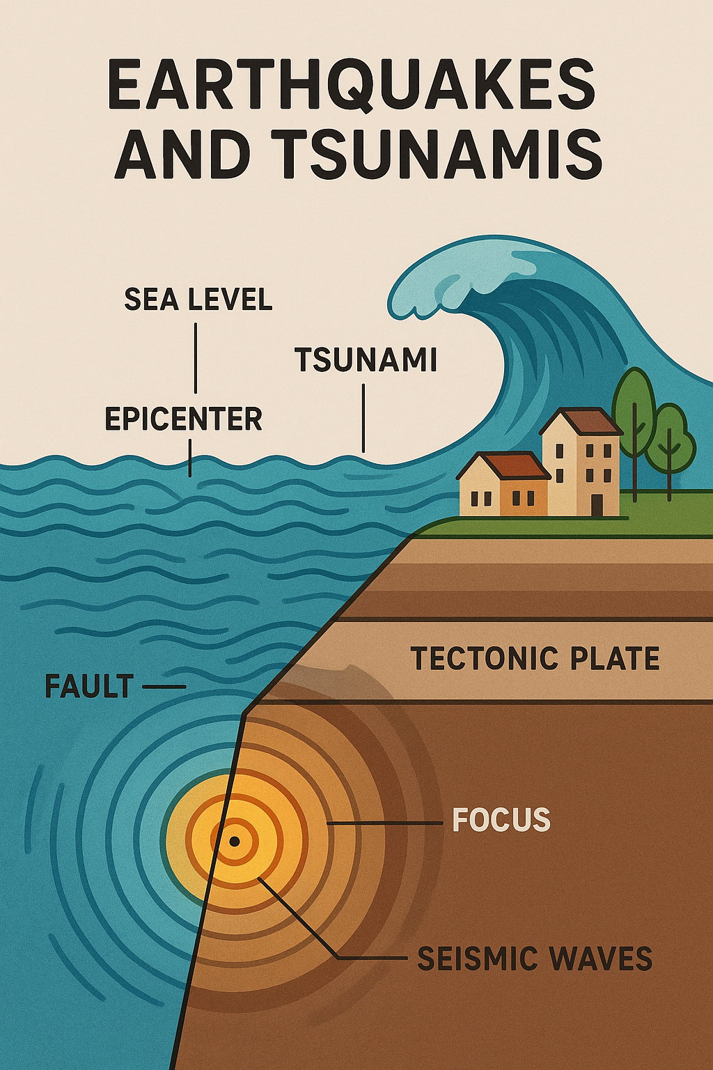
An earthquake is the sudden shaking of the ground caused by the release of energy stored in the Earth’s crust. This energy release generates seismic waves, which propagate through the Earth’s surface.
Causes of Earthquakes:
- Plate Tectonics: The movement and interaction of lithospheric plates, especially at fault zones.
- Volcanic Activity: Earthquakes often precede or accompany volcanic eruptions.
- Isostatic Rebound: Adjustment of Earth’s crust due to the removal of glacial load.
- Human-Induced Activities: Reservoir-induced seismicity, mining, and underground nuclear testing.
-
Best geography optional coaching
2. Types of Earthquakes
- Tectonic Earthquakes: Due to the release of stress accumulated along faults.
- Volcanic Earthquakes: Caused by magma movement.
- Collapse Earthquakes: Due to underground mine collapses or cave-ins.
- Explosion Earthquakes: Caused by nuclear and chemical explosions.
3. Seismic Waves
There are two major types of seismic waves:
- Body Waves: Travel through the interior (P-waves and S-waves).
- Surface Waves: Travel along the Earth’s surface (Love and Rayleigh waves).
Earthquakes and Tsunamis image
4. Measurement of Earthquakes
- Richter Scale: Measures magnitude based on energy released.
- Moment Magnitude Scale: A more accurate scale that replaced the Richter Scale.
- Mercalli Intensity Scale: Measures the impact and damage caused.
5. Earthquake Zones of India
India is divided into four seismic zones: Zone II (low risk), Zone III (moderate), Zone IV (high), and Zone V (very high).
Major earthquakes in India include:
- Bihar-Nepal Earthquake (1934)
- Bhuj Earthquake (2001)
- Kashmir Earthquake (2005)
6. Tsunamis: Meaning and Causes
A tsunami is a series of large sea waves caused by the displacement of water due to an undersea earthquake, landslide, or volcanic eruption.
Causes of Tsunamis:
- Submarine Earthquakes at convergent plate boundaries
- Volcanic eruptions (e.g., Krakatoa 1883)
- Landslides and glacier calving
- Asteroid impacts
7. Characteristics of Tsunamis
- Long wavelengths (up to hundreds of kilometers)
- High speed (up to 800 km/h in deep water)
- Amplification as it approaches shallow coastal areas
- Often come in multiple waves (“wave train”)
8. Impacts of Earthquakes and Tsunamis
Environmental:
- Land subsidence/uplift
- Soil liquefaction
- Disruption of ecosystems
Social and Economic:
- Loss of human life
- Destruction of infrastructure
- Displacement of populations
- Long-term economic setbacks
9. Monitoring and Mitigation
For Earthquakes:
- Seismographs and accelerometers
- Microzonation mapping
- Earthquake-resistant construction
- Public drills and education
For Tsunamis:
- Deep Ocean Assessment and Reporting of Tsunami (DART) system
- Warning centers (INCOIS in India)
- Coastal zoning and green belts
- Evacuation planning
10. Past Year UPSC Questions
- 2021: Explain the causes and effects of tsunami with suitable examples.
- 2017: Discuss the major earthquake-prone zones in India and their mitigation strategies.
- 2013: Explain the mechanism of earthquake waves and their impacts.
11. Probable Questions for UPSC
- Discuss the measures taken by India for earthquake disaster preparedness and mitigation.
- Examine the role of plate tectonics in the generation of tsunamis with suitable examples.
- Why are tsunamis more destructive in certain geographic regions? Discuss.
12. Conclusion
Understanding earthquakes and tsunamis is vital not only for academic purposes but also for policy-making and disaster preparedness. As the population increases and urban centers expand into seismic zones, it becomes even more critical to integrate geoscientific knowledge into developmental planning and risk reduction.

No Comments