
17 Oct Ferry Service across Palk Strait
This article covers “Daily Current Affairs” and the topic details “Ferry Service across Palk Strait”. This topic has relevance in the Geography section of the UPSC CSE exam.
GS 1: Geography
Why in the news?
India and Sri Lanka inaugurated a ferry service across the Palk Strait, marking a significant step toward enhanced connectivity. This initiative comes nearly 40 years after the civil war in Sri Lanka disrupted the link between Nagapattinam in Tamil Nadu and Kankesanthurai in Jaffna.
The newly launched ferry service is anticipated to have a positive impact on travel and trade with Kankesanthurai, which is the Sri Lankan port closest to ports situated on the west coast of India.
Background:
- The Palk Strait, a narrow body of water separating India and Sri Lanka, has been a source of contention between the two countries, primarily concerning the sharing of fish resources.
- This strait is known for being a critical breeding ground for marine resources, particularly shrimp.
- Despite an agreement reached in the 1970s to establish an imaginary boundary line called the International Maritime Boundary Line (IMBL), Indian fishermen, predominantly from Tamil Nadu and Puducherry, continue to face arrests by the Sri Lanka Navy for alleged “poaching” or “illegal” fishing within Sri Lankan waters.
- Both governments have engaged in numerous rounds of bilateral negotiations, and fishing community leaders from both sides have held talks over the years. However, a lasting solution to this issue remains elusive.
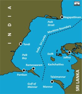
About Palk Strait:
- The Palk Strait is a narrow body of water connecting India’s Tamil Nadu state to the island nation of Sri Lanka.
- It derives its name from Robert Palk, who was a British Raj administrator in the Madras Presidency from 1755 to 1763.
- The strait is bordered by Pamban Island (India) on the east, Adam’s Bridge (also known as Rama’s Bridge, a chain of shoals), the Gulf of Mannar, and Mannar Island (Sri Lanka) to the west.
- It serves as a crucial link between the northeastern Bay of Bengal in the north and the southwesterly Gulf of Mannar in the south.
- The southwestern section of the strait is often referred to as Palk Bay.
- The Palk Strait has a length ranging from 40 to 85 miles (approximately 64 to 137 kilometers) and a depth of less than 330 feet (about 100 meters).
- Various rivers, including the Vaigai River in Tamil Nadu, flow into the strait.
- The port of Jaffna, which is a significant commercial center in northern Sri Lanka, is located along the shores of the Palk Strait.
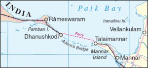
About Adam’s Bridge:
- Adam’s Bridge is a formation of limestone shoals that connects Pamban Island, also known as Rameswaram Island, located off the southeast coast of Tamil Nadu, India, and Mannar Island, situated off the northwest coast of Sri Lanka.
- Geologically, this bridge was once a land route that connected India and Sri Lanka.
- The length of the bridge is approximately 50 kilometers, and it serves as a link between the Gulf of Mannar to the southwest and the Palk Strait to the northeast.
- Parts of the sandbanks are dry, and the sea in the area is quite shallow, with depths ranging from 1 to 10 meters in various places, making navigation challenging.
- According to scientific understanding, Ram Setu, or Adam’s Bridge, is a natural formation resulting from tectonic movements and the accumulation of sand in corals.
- This structure holds cultural and religious significance in both Hindu and Muslim traditions. Hindus believe it to be the bridge constructed by Lord Ram and his army to cross to Lanka and confront Ravan. In Islamic legend, it is associated with Adam, who, according to belief, used the bridge to reach Adam’s Peak in Sri Lanka, where he stood on one foot in repentance for 1,000 years.
SOURCE: Lanka-India ferry service resumes after 40 years
Download plutus ias current affairs eng med 17th Oct 2023
Q.1 Consider the following statements about the Palk Strait:
- The Vaigai River flows into the Palk Strait.
- The Palk Strait connects Tamil Nadu to Sri Lanka.
Which of the statements given above is/are correct?
(a) 1 only
(b) 2 only
(c) Both 1 and 2
(d) Neither 1 nor 2
Q.2 Consider the following statements about the Palk Strait:
- The port of Jaffna is situated along the Palk Strait.
- The Port of Mangalore is situated along the Palk Strait.
Which of the statements given above is/are correct?
(a) 1 only
(b) 2 only
(c) Both 1 and 2
(d) Neither 1 nor 2
Q.3 Discuss the strategic significance of the Palk Strait in the context of maritime security and its implications for India-Sri Lanka relations.

No Comments