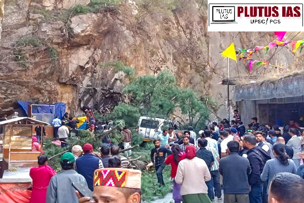
Six people lost their lives, and three were injured after a massive tree, uprooted by heavy rains and a landslide, fell on parked vehicles near Gurudwara Manikaran Sahib on Sunday. Officials said the tree collapsed from a mountain opposite the gurudwara due to continuous rainfall. The injured were taken to Jari Hospital for treatment. Kullu SDM Vikas Shukla confirmed that emergency teams, including police and medical personnel, managed rescue efforts. Himachal Pradesh CM Sukhvinder Singh Sukhu directed authorities to provide all possible aid, while Leader of Opposition Jai Ram Thakur expressed condolences.
What is a landslide?
A landslide is defined as the movement of a mass of rock, debris, or earth down a slope. Landslides are a type of “mass wasting,” which denotes any down-slope movement of soil and rock under the direct influence of gravity. The term “landslide” encompasses five modes of slope movement: falls, topples, slides, spreads, and flows. These are further subdivided by the type of geologic material (bedrock, debris, or earth). Debris flows (commonly referred to as mudflows or mudslides) and rock falls are examples of common landslide types.
India’s vulnerability to landslide
| Category |
Details |
| Vulnerable Land Area |
12.6% of India’s land (excluding snow-covered areas) is landslide-prone. |
| Most Affected Regions |
Himalayas, Western Ghats, Northeast India, Eastern Ghats, Kerala, Sikkim, Arunachal Pradesh. |
| Key Reports |
ISRO Landslide Atlas: Mapped 80,000 landslides in 17 states, 2 UTs.
GSI Report: Confirms 12.6% of land area at risk. |
| Main Causes |
Geological Factors: Young, unstable mountains (Himalayas, Western Ghats).
Climate & Rainfall: Intense monsoons weaken slopes.
Human Activities: Deforestation, unscientific road construction, mining, and farming on steep slopes.
Earthquakes: Frequent seismic activity in the Himalayan region triggers landslides.
Soil Erosion: Riverbank erosion makes slopes unstable. |
| Impacts |
Loss of Life: High fatalities in densely populated hilly regions.
Infrastructure Damage: Roads, bridges, power lines, and buildings destroyed.
Economic Losses: Disrupts agriculture, tourism, and transportation.
Environmental Degradation: Causes deforestation, loss of biodiversity, and landslide-induced flooding. |
Cause of landslide
1. Heavy Rainfall & Flooding: Excessive water saturates the soil, reducing its strength and triggering landslides, especially during monsoons.
2. Earthquakes & Seismic Activity: Ground vibrations destabilize slopes, leading to rockfalls and landslides, particularly in mountainous regions.
3. Volcanic Eruptions: Lava flows, ash deposits and explosions can weaken slopes, causing sudden landslides.
4. Snowmelt & Glacier Movement: Rapid melting of snow and glaciers increases water infiltration, loosening soil and rock.
5. Soil Erosion: Rivers, wind, and weathering gradually wear down slopes, making them more prone to collapse over time.
6. Deforestation: Cutting down trees removes the root systems that hold the soil together, increasing the risk of landslides.
7. Unplanned Construction & Excavation: Poorly planned buildings, roads, and tunnels disturb natural slopes, leading to instability.
8. Mining & Quarrying: Blasting and excavation weaken the ground, often triggering landslides in hilly and mountainous areas.
9. Poor Drainage Systems: Improper water management causes water accumulation, weakening soil strength and increasing landslide risks.
10. Climate Change & Extreme Weather: Rising global temperatures lead to intense rainfall, glacier melting, and unpredictable weather patterns, making landslides more frequent and severe.
Consequence of landslide
1. Loss of Life & Injuries: Landslides can bury homes and villages, leading to fatalities and serious injuries.
2. Destruction of Property & Infrastructure: Houses, roads, bridges, and railways can be destroyed, causing severe disruptions.
3. Economic Losses: Damage to businesses, agriculture, and industries results in financial setbacks and loss of livelihoods.
4. Displacement & Migration: Affected communities may be forced to relocate, leading to social and economic challenges.
5. Soil Erosion & Reduced Fertility: Landslides strip away topsoil, making land unsuitable for agriculture and reducing productivity.
6. Loss of Vegetation & Biodiversity: Forests and ecosystems are destroyed, leading to habitat loss and declining wildlife populations.
7. Water Contamination & Shortages: Landslides can pollute water sources and disrupt natural water flow, impacting supply and quality.
8. Flash Floods & Landscape Changes: Blocked rivers can create temporary lakes that may burst, causing devastating floods and altering geography.
NDMA Guideline on landslide
| Category |
Key Measures |
Details |
| Landslide Hazard, Vulnerability & Risk Assessment |
Identifying High-Risk Areas |
Mapping and analyzing landslide-prone zones. |
|
Assessing Infrastructure & Populations at Risk |
Evaluating buildings, roads, and communities vulnerable to landslides. |
| Early Warning Systems |
Continuous Monitoring |
Using sensors, satellite data, and geotechnical instruments to detect ground movement. |
|
Timely Alerts & Data Sharing |
Communicating risk data quickly to authorities and the public. |
| Landslide Risk Mitigation & Remediation |
Land Use Planning |
Restricting development in landslide-prone areas. |
|
Enforcing Construction Standards |
Implementing safer excavation and building regulations. |
|
Protective Infrastructure |
Installing retaining walls, rock anchors, and other stabilizing structures. |
|
Slope Stabilization |
Improving drainage, vegetation cover, and controlled debris removal. |
|
Landslide Insurance & Compensation |
Providing financial support to affected communities. |
| National Landslide Risk Management Strategy |
Comprehensive Risk Reduction Plan |
Integrating hazard mapping, awareness programs, capacity building, and regulations. |
|
NDMA Task Force |
Developing national and local-level strategies for landslide management. |
|
Strategy Document |
Covering all aspects of landslide risk reduction. |
| NDMA Guidelines on Landslide & Snow Avalanche Management |
National Landslide Policy (2009) |
Official guidelines for landslide disaster management. |
|
Landslide Risk Mitigation Scheme (LRMS) – 2019 |
Financial and technical assistance for landslide-prone states. |
|
LRMS Key Objectives |
Focus on prevention, mitigation, early warning systems, and capacity building. |
Challenges to reduce the landslide
1. Lack of Accurate and Comprehensive Data: Incomplete or outdated landslide hazard maps hinder effective risk assessment and mitigation.
2. Unregulated Construction in Vulnerable Areas: Rapid urbanization and infrastructure development in landslide-prone regions increase risks.
3. Deforestation and Environmental Degradation: Uncontrolled deforestation weakens slopes, making them more prone to landslides.
4. Poor Drainage and Water Management: Inadequate drainage systems increase soil saturation, leading to slope failures.
5. Limited Implementation of Early Warning Systems: Lack of proper monitoring networks and real-time data delays warnings and response efforts.
6. Climate Change and Extreme Weather Events: Intense rainfall, rising temperatures, and unpredictable weather patterns worsen landslide frequency.
7. Inadequate Public Awareness and Preparedness: Communities in high-risk zones often lack knowledge of landslide risks and safety measures.
8. Lack of Strict Policy Enforcement: Weak enforcement of land-use regulations and construction guidelines allows unsafe development.
9. Limited Financial and Technological Resources: Insufficient funding and technology slow down landslide mitigation projects.
Way forward
1. Strengthen Early Warning Systems: Implement real-time monitoring using sensors, satellite imagery, and AI-based prediction models.
2. Improve Land Use Planning & Regulations: Enforce strict zoning laws to prevent construction in high-risk areas. Implement eco-friendly infrastructure development in vulnerable regions.
3. Enhance Slope Stabilization Measures: Use retaining walls, vegetation cover, and proper drainage systems to reinforce slopes. Promote bioengineering techniques for sustainable landslide prevention.
4. Increase Public Awareness & Community Preparedness: Conduct education campaigns on landslide risks and safety measures. Train local communities in disaster preparedness and evacuation drills.
5. Leverage Technology & Research for Risk Mitigation: Encourage research on cost-effective landslide mitigation techniques. Use drones, LiDAR, and GIS mapping for precise hazard assessment.
6. Implement Sustainable Environmental Practices: Promote afforestation and soil conservation techniques to stabilize slopes. Control deforestation and unplanned mining activities to reduce environmental stress.
7. Strengthen National Landslide Policy & Funding: Expand financial assistance programs like LRMS for high-risk states. Invest in disaster resilience infrastructure and emergency response teams.
Conclusion


No Comments