
28 Feb National Geospatial Policy: Powering India’s Vision for Viksit Bharat
This article covers “Daily Current Affairs” and Topic details National Geospatial Policy: Powering India’s Vision for Viksit Bharat
SYLLABUS MAPPING:
GS-3- Science & Technology- National Geospatial Policy: Powering India’s Vision for Viksit Bharat
FOR PRELIMS
What is National Geospatial Policy Operations Dronagiri and National Data Repository?
FOR MAINS
Why in the news?
The National Geospatial Policy, 2022, launched by the Government of India, is in the news for its transformative approach to making India a global leader in geospatial technology. The policy focuses on liberalizing access to geospatial data, ensuring publicly funded datasets are openly available, and fostering innovation across governance, businesses, and academia. Key goals include developing a high-resolution mapping system and a Digital Elevation Model (DEM) by 2030. The policy aims to strengthen institutional frameworks, enhance national coordination, and promote the reuse of geospatial data, paving the way for economic growth and technological advancement.
What is Geospatial data?
Geospatial data refers to information that describes objects, events, or features with a specific location on or near the Earth’s surface. It combines location (coordinates), attributes (characteristics of the object), and temporal information (time or lifespan). Geospatial data can be static (e.g., a piece of equipment’s location) or dynamic (e.g., the movement of a vehicle or the spread of disease). This data is gathered from diverse sources like satellite imagery, weather data, census data, social media, and more. It’s most valuable when shared, analyzed, and combined with traditional data. Geospatial analytics enhances data by adding location and time, creating visualizations such as maps and graphs that reveal patterns and insights for better predictions. Geospatial Information Systems (GIS) visualize and map this data, enabling applications like overlaying hurricane data with lightning strike risk areas.
What is National Geospatial Policy?
The National Geospatial Policy 2022 is a strategic framework introduced by the Government of India on December 28, 2022, aimed at leveraging geospatial technologies to promote national development, economic growth, and global leadership in the geospatial sector. This policy envisions India as a global leader in geospatial data usage and technology by creating an enabling environment for its widespread adoption across various sectors such as governance, business, academia, and citizen services.
Goals of the National Geospatial Policy(NGP)
1. By 2025
Establish an enabling policy and legal framework to support the liberalization of the geospatial sector and democratization of data.
Enhance availability and accessibility of high-quality location data across sectors to drive innovation and enterprise.
Develop a unified digital interface for accessing geospatial data collected through public funds.
Redefine the National Geodetic Framework using modern positioning technologies with online accessibility.
Create a high-accuracy geoid model for the entire country.
Strengthen national and sub-national geospatial governance by fostering collaboration between the government, private sector, academia, and civil society.
2. By 2030
Conduct high-resolution topographical surveys (5–10 cm for urban/rural areas and 50–100 cm for forests/wastelands).
Develop a high-accuracy Digital Elevation Model (DEM) (25 cm for plains, 1–3 m for hilly/mountainous areas).
Establish a Geospatial Knowledge Infrastructure (GKI) underpinned by an Integrated Data and Information Framework.
Enhance geospatial skills, capabilities, and awareness to meet future technological and economic demands.
3. By 2035
Generate high-resolution bathymetric geospatial data for inland waters and deep-sea topography to support the Blue Economy.
Survey and map sub-surface infrastructure in major cities and towns.
Develop a National Digital Twin for major urban centres, creating digital replicas to improve urban planning and management.
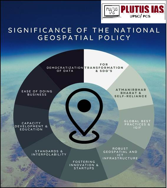
Key Focus Areas of the National Geospatial Policy
1. Geospatial for Transformation & SDGs: The policy positions geospatial technology and data as key drivers for achieving Sustainable Development Goals (SDGs), enhancing efficiency across sectors, and ensuring transparency in governance.
2. Atmanirbhar Bharat & Self-Reliance: Recognizing the need for locally relevant geospatial data, the policy aims to foster a self-reliant geospatial ecosystem, empowering Indian companies to compete globally and reduce dependency on foreign providers.
3. Global Best Practices & IGIF: Adopting international frameworks like the Integrated Geospatial Information Framework (IGIF) under UN-GGIM, the policy strengthens India’s national spatial information management.
4. Robust Geospatial & ICT Infrastructure: Establishing a well-defined data custodianship model to ensure the collection, management, and real-time accessibility of high-quality geospatial data for cross-sector collaboration.
5. Fostering Innovation & Startups: Encouraging startups, R&D, and emerging technologies, the policy promotes regulatory modernization and bridges the geospatial digital divide.
6. Standards & Interoperability: Advocating open standards, open data, and compliance frameworks, the policy ensures seamless integration and interoperability of geospatial information.
7. Capacity Development & Education: Promoting geospatial education from school levels alongside standardized certifications and skill development programs to sustain long-term industry growth.
8. Ease of Doing Business: Continued policy liberalization to attract investment, facilitate business-friendly regulations, and support geospatial enterprises.
9. Democratization of Data: Survey of India (SoI) and other publicly funded geospatial data will be treated as a public good, ensuring easy access and utilization for all stakeholders.
National Geospatial Policy in Action:
1. PM Gati Shakti: Integrates geospatial data for efficient infrastructure development across multiple sectors, enhancing coordination between ministries and improving project planning.
2. National Geospatial Data Repository: A centralized platform for seamless sharing and access to high-quality geospatial data across sectors, supporting better governance and business decisions.
3. Operation Dronagiri: A pilot project that demonstrates the practical use of geospatial technologies in urban planning, disaster management, and governance. It includes an Integrated Geospatial Data Sharing Interface for better cross-sector collaboration.
4. Survey of India (SoI): The establishment of the CORS network for high-accuracy location data and the SVAMITVA Scheme, which uses drone technology to map villages and streamline land records.
5. Innovation and Startups: Encourages the development of geospatial technology parks, incubation centres, and partnerships with academia and the private sector for research and product development.
6. Education and Capacity Building: Promotes geospatial training programs and skill development to support the growing industry.
7. Private Sector Engagement: Promotes open data access and business-friendly regulations to drive innovation and private sector growth in the geospatial sector.
8. Sustainable Development Goals (SDGs): Leverages geospatial data for efficient planning in sectors like agriculture, urban development, and environmental conservation, contributing to India’s SDGs.
Siginifnace of National Geospatial Policy
Challenges in National Geospatial Policy Implementation:
1. Data Privacy and Security: Open access to geospatial data raises concerns about national security and citizen privacy.
2. Data Quality and Standardization: Ensuring consistent, high-quality, and standardized geospatial data across sectors is challenging.
3. Infrastructure and Technology Gaps: Lack of infrastructure and technological limitations, especially in remote areas, hinder data collection and sharing.
4. Skill Shortages: There’s a shortage of trained professionals in geospatial technologies and insufficient educational integration.
5. Financial Constraints: Limited funding for infrastructure development, surveys, and long-term projects.
6. Regulatory and Policy Hurdles: Regulatory resistance and unclear policies may slow liberalization and private sector involvement.
7. PPP Challenges: Private sector reluctance due to data security concerns and unclear profit models.
8. Inclusion and Equity: Unequal access to technology, especially in remote areas, may hinder inclusive development.
9. Environmental and Social Concerns: Large-scale data collection raises environmental and social issues, including land rights and surveillance concerns.
Way forward
1. Enhance Data Quality and Standardization: Ensure consistent, accurate, and high-quality geospatial data across all sectors through standardized protocols and frameworks.
2. Strengthen Infrastructure: Develop robust technological infrastructure, especially in remote and rural areas, to enable better data collection, sharing, and access.
3. Build a Skilled Workforce: Invest in education and training programs to develop a workforce proficient in geospatial technologies, supporting industry growth and innovation.
4. Promote Public-Private Partnerships (PPP): Encourage private sector involvement through clear regulatory frameworks, incentives, and collaboration to drive innovation and investment in geospatial technologies.
5. Ensure Data Privacy and Security: Address concerns over data privacy by implementing secure systems for data sharing and access, balancing transparency with national security.
6. Foster Inclusive Development: Ensure equitable access to geospatial technologies and data, bridging the digital divide and empowering remote and underserved regions.
Conclusion
The National Geospatial Policy 2022 is a transformative step towards unlocking the potential of geospatial data for national development. By addressing challenges in data access, quality, and infrastructure, India can leverage geospatial technology to drive growth, innovation, and sustainable development across various sectors. The policy’s focus on liberalizing data access, fostering public-private partnerships, and enhancing skill development will play a crucial role in accelerating the adoption of geospatial technologies across governance, businesses, and academia.
Download Plutus IAS Current Affairs (Eng) 28th Feb 2025
Prelims Questions:
Q. With reference to the National Geospatial Policy 2022, which of the following statements is/are correct?
1. The policy aims to make all geospatial data generated with public funds freely accessible to citizens.
2. The policy envisions the creation of a National Digital Twin for major urban centres by 2035.
Select the correct answer using the code given below:
A. 1 only
B. 2 only
C. Both 1 and 2
D. Neither 1 nor 2
Answer: C
Mains Questions:
(250 words, 15 marks)

No Comments