
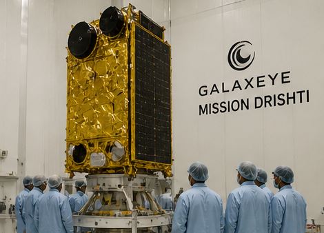
04 May Mission Drishti (GalaxEye): Advancing India’s Earth Observation Capabilities
This article covers “Daily Current Affairs”
SYLLABUS MAPPING : GS Paper 3 : Science and Technology
FOR PRELIMS : Mission Drishti , Synthetic Aperture Radar , Private Sector in Space, etc.
FOR MAINS : Examine the role of private sector participation in India’s space sector, with reference to Mission Drishti.
Context
- The Prime Minister recently congratulated the team behind the successful launch of Mission Drishti, developed by GalaxEye. The mission aims to strengthen India’s Earth observation capabilities using Synthetic Aperture Radar (SAR) technology, which enables all-weather, day-and-night imaging.
- This development reflects India’s growing focus on space-based surveillance, geospatial intelligence, and private sector participation, marking a shift towards a more innovation-driven space ecosystem.
About Mission Drishti
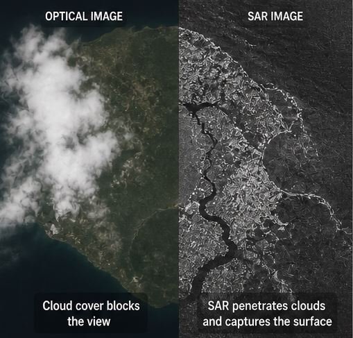
- Mission Drishti is an advanced Earth observation initiative designed to provide high-resolution imaging irrespective of weather conditions or time of day. Unlike traditional optical satellites, it uses radar-based sensing, which significantly improves reliability in challenging environments such as cloud cover, fog, or darkness.
- The mission represents a major step in integrating private space startups into India’s space ecosystem, complementing institutions like ISRO and supporting the government’s push for space sector reforms.
What is Synthetic Aperture Radar (SAR)?
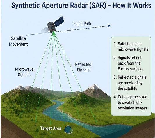
- Synthetic Aperture Radar (SAR) is a remote sensing technology that uses microwave radar signals to generate images of the Earth’s surface. Unlike optical imaging, SAR systems actively emit signals and record their reflections, allowing them to function independently of sunlight.
- A key advantage of SAR is its ability to operate in all-weather conditions, as microwave signals can penetrate clouds, rain, and fog, making it highly effective for continuous monitoring.
- SAR also provides high-resolution and detailed surface data, including terrain features, moisture levels, and structural changes, which are crucial for both civilian and strategic applications.
Key Features of Mission Drishti
- The mission offers persistent monitoring capability, enabling continuous observation without interruptions caused by weather or lighting conditions. This is particularly significant for India, where monsoon cloud cover often limits traditional satellite imaging.
- It ensures high revisit frequency, allowing near real-time data availability, which is critical for time-sensitive applications such as disaster response and surveillance.
- The integration of AI-driven data processing and analytics enhances the usability of satellite data, enabling faster and more accurate decision-making.
- Mission Drishti also has a dual-use nature, supporting both civilian applications (agriculture, disaster management) and strategic purposes (border security, maritime monitoring).

Significance of the Mission
- Mission Drishti significantly enhances India’s geospatial intelligence capabilities by enabling 24×7 monitoring of land and maritime regions, which is crucial for disaster preparedness and national planning.
- From a strategic perspective, SAR-based imaging strengthens border surveillance, particularly in sensitive regions where visibility is often compromised, and contributes to improved maritime domain awareness.
- Economically, the mission supports sectors such as agriculture (crop monitoring), infrastructure planning, and urban development, by providing accurate and timely geospatial data.
- It also aligns with India’s ambition to become a global leader in space technology and satellite data services, boosting the country’s position in the global space economy.
Role of Private Sector in Space (GalaxEye’s Contribution)
- The involvement of GalaxEye highlights the increasing role of private players in India’s space sector, especially after policy reforms that opened up the sector to startups.
- Private companies bring innovation, cost efficiency, and agility, complementing traditional organizations like ISRO, and accelerating technological development.
- This collaboration model is essential for scaling India’s capabilities in satellite manufacturing, data services, and global competitiveness.
Challenges
- SAR technology involves high development and operational costs, which may limit scalability and require sustained investment.
- Processing SAR data is technically complex and computationally intensive, necessitating advanced infrastructure and skilled manpower.
- There are also concerns related to data privacy and security, given the high-resolution imaging capabilities and potential dual-use nature of the technology.
- Effective integration of private sector innovations with government frameworks requires robust regulation and coordination mechanisms.
Way Forward
- India should strengthen public-private partnerships in the space sector to fully leverage innovations from startups like GalaxEye and enhance overall capability.
- Investment in advanced data processing infrastructure, AI integration, and human resource development is essential to maximize the utility of SAR-based systems.
- Expanding the application of Earth observation data across sectors such as agriculture, disaster management, and urban governance will improve policy effectiveness.
- Strengthening regulatory frameworks through institutions like IN-SPACe will ensure smooth collaboration while addressing concerns related to security and data governance.
- In the long term, missions like Drishti can position India as a leader in Earth observation and geospatial intelligence, contributing to both national development and global data services.
Prelims Question
Q. With reference to Synthetic Aperture Radar (SAR), consider the following statements:
- SAR uses microwave signals to capture images of the Earth’s surface.
- SAR imaging depends on sunlight for operation.
- SAR can penetrate clouds and provide images during adverse weather conditions.
Which of the statements given above is/are correct?
(a) 1 and 3 only
(b) 1 and 2 only
(c) 2 and 3 only
(d) 1, 2 and 3
Answer: (a) 1 and 3 only
Explanation:
Statement 1 is correct as SAR uses microwave signals. Statement 2 is incorrect because SAR does not depend on sunlight. Statement 3 is correct as SAR can function through clouds and adverse weather.
Mains Questions
Discuss the significance of Synthetic Aperture Radar (SAR) technology in enhancing India’s Earth observation capabilities. (15M).
- India’s Push Beyond E20 Fuel: Reasons, Pitfalls, and the Flex Fuel Future - June 15, 2026
- RBI’s Reviving of FCNR(B) Swap Scheme again in 2026 - June 15, 2026
- Modi’s France Visit & the 52nd G7 Summit - June 13, 2026

No Comments