


04 Aug स्वामित्व योजना: 3.30 लाख गांवों में ड्रोन सर्वेक्षण पूरा, जानें कैसे मिलेगा संपत्ति अधिकार
✎ SVAMITVA Scheme leverages drone surveys and CORS technology to digitise rural land records, issue property cards, and facilitate financial inclusion through transparent land titles.
 Property cardsDrone surveysLand recordsRural mappingCORS network
Subject Relevance — Where This Topic Fits
- GS Paper II — Governance, Transparency and Accountability in Administration | GS Paper III — Land Reforms, Digital Infrastructure and Financial Inclusion
- Prelims: SVAMITVA Scheme, Property Rights in Rural India, Drone Survey and CORs Technology, Land Records Modernisation, Financial Inclusion through Land Titles, Panchayati Raj Institutions (PRIs), State Level Bankers’ Committee (SLBC), Record of Rights (RoR), Digital Mapping of Rural Land
- Essay: Digital Transformation in Governance: Balancing Efficiency and Equity, Land Reforms in India: From Redistribution to Digitisation
Quick Revision: SVAMITVA Scheme leverages drone surveys and CORS technology to digitise rural land records, issue property cards, and facilitate financial inclusion through transparent land titles.
Why is this in the news?
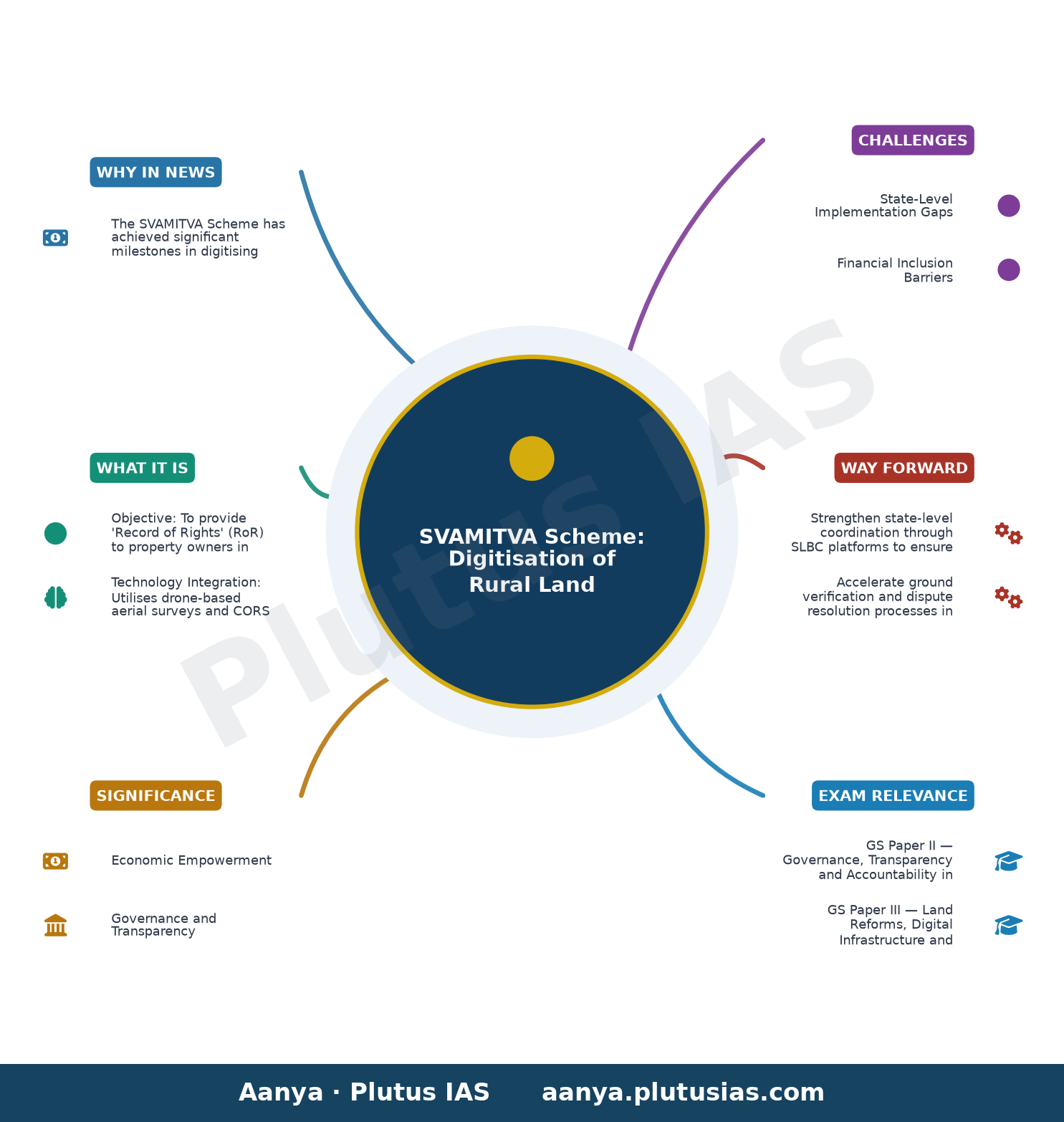
The SVAMITVA Scheme has achieved significant milestones in digitising rural land records, with drone surveys completed in 3.30 lakh villages and 2.72 crore property cards distributed to landowners. This initiative, spearheaded by the Ministry of Panchayati Raj, aims to reduce property disputes, facilitate institutional credit access, and empower rural populations through transparent land records. Recent data on financial inclusion through property cards and state-wise progress highlights its evolving role in rural governance and economic empowerment.
Background
- Launched in April 2020 as a Central Sector Scheme under the Ministry of Panchayati Raj, SVAMITVA (Survey of Villages and Mapping with Improvised Technology in Village Areas) is a pan-India initiative to map rural inhabited areas using advanced technologies like drones and Continuous Operating Reference Stations (CORS).
- The scheme addresses long-standing challenges in rural land governance, including ambiguous property boundaries, lack of formal land titles, and disputes arising from overlapping claims.
- Prior to SVAMITVA, rural land records were often outdated, manually maintained, and prone to errors, leading to inefficiencies in land transactions and credit access.
- The scheme aligns with the Digital India initiative, leveraging geospatial technology to create high-precision maps and property records.
- It complements existing land reform efforts, such as the Digital Land Records Modernisation Programme (DILRMP), by providing a technology-driven solution to land governance.
- The scheme is distinct from eGramSwaraj, which focuses on planning, accounting, and monitoring for Panchayati Raj Institutions (PRIs), while SVAMITVA targets land record digitisation and property rights.
What is the SVAMITVA Scheme?
- Objective: To provide ‘Record of Rights’ (RoR) to property owners in rural inhabited areas, thereby establishing clear land titles and reducing disputes.
- Technology Integration: Utilises drone-based aerial surveys and CORS technology to create high-accuracy maps of rural lands, ensuring precise demarcation of property boundaries.
- Property Cards: Issues legal property cards to landowners, which serve as prima facie evidence of ownership and facilitate access to institutional credit.
- Financial Inclusion: Enables banks to accept SVAMITVA property cards as collateral for loans, thereby enhancing rural credit access.
- Institutional Framework: Operates under the Ministry of Panchayati Raj, with collaboration from the Department of Financial Services and state revenue departments to ensure seamless implementation.
- Progress Tracking: Monitors implementation through state-wise and district-wise dashboards, with funds allocated to the Survey of India for drone surveys and mapping activities.
- Dispute Resolution: Incorporates a transparent process for ground verification and dispute resolution to ensure accuracy and fairness in land records.
- Coverage: Aims to cover 3.38 lakh villages across India, with significant progress already achieved in states like Gujarat, Maharashtra, and Madhya Pradesh.
Key Features
| Feature | Significance |
|---|---|
| Drone-based Cadastral Survey | Generates high-precision geospatial data for rural land parcels using CORS technology, ensuring accurate boundary delineation and reducing land disputes. |
| Property Cards (Record of Rights) | Formalises ownership rights in rural areas, providing legal recognition and facilitating institutional credit access for asset owners. |
| State-Level Coordination via SLBC | Enables systematic acceptance of property cards by banks through State Level Bankers’ Committees, streamlining loan disbursement processes. |
| Integration with Revenue Administration | Collaboration between Panchayati Raj Ministry, Department of Financial Services, and State Revenue Departments ensures seamless implementation and validation of property records. |
| Monitoring and Target Achievement | Panchayati Raj Ministry tracks progress in real-time to ensure all 3.38 lakh villages are surveyed within the stipulated timeline. |
Why it Matters
Economic Empowerment
- Facilitates institutional credit access for rural landowners by providing verifiable property records, thereby unlocking economic potential in agrarian and peri-urban economies.
- Enhances asset monetisation opportunities, enabling landowners to leverage property cards for loans, investments, or collateral in financial markets.
- Promotes formalisation of rural land markets, reducing informality and fostering transparency in land transactions.
Governance and Transparency
- Creates a reliable and tamper-proof land record system, minimising disputes arising from ambiguous or conflicting ownership claims.
- Strengthens the efficacy of Panchayati Raj institutions by providing accurate cadastral data for decentralised planning and resource allocation.
- Supports evidence-based policy formulation in rural development, land reforms, and infrastructure planning.
Technological Advancement
- Demonstrates the application of geospatial technologies (UAVs, CORS) in large-scale land surveying, setting a precedent for future digital governance initiatives.
- Ensures interoperability with existing digital infrastructure, such as e-Gram Swaraj, while maintaining functional independence to preserve data integrity.
Social Equity
- Provides marginalised landowners, particularly women and Scheduled Tribes, with legal recognition of their property rights, enhancing socio-economic security.
- Reduces vulnerability to land grabbing and forced dispossession by establishing clear, documented ownership records.
Challenges
1. State-Level Implementation Gaps
- Variations in administrative capacity across states lead to disparities in survey completion and property card distribution, as evidenced by incomplete coverage in states like Arunachal Pradesh and Jharkhand.
- Delays in ground verification and dispute resolution processes in certain regions hinder the timely issuance of property cards.
UPSC Link: 73rd Constitutional Amendment Act – Panchayati Raj Institutions
2. Financial Inclusion Barriers
- Limited awareness among rural populations regarding the utility of property cards for availing loans restricts their adoption by banks and financial institutions.
- Banks in some states exhibit reluctance to accept property cards as collateral due to perceived risks in land valuation and legal ambiguities.
UPSC Link: Priority Sector Lending – RBI Guidelines
3. Technological and Logistical Constraints
- High dependence on drone surveys and CORS infrastructure may face operational challenges in remote or terrain-restricted areas.
- Ensuring data accuracy and preventing duplication in large-scale surveys requires robust quality control mechanisms.
UPSC Link: Digital India Land Records Modernisation Programme
4. Legal and Procedural Hurdles
- Inheritance laws and customary practices in certain communities may conflict with formal land records, necessitating community sensitisation and legal harmonisation.
- Dispute resolution mechanisms require streamlined grievance redressal to prevent prolonged litigation and ensure public trust.
UPSC Link: Land Acquisition Act, 2013 – Section 105
Challenges — UPSC Perspective
| Issue | Concern |
|---|---|
| Incomplete Survey Coverage | States like Arunachal Pradesh and Jharkhand show negligible progress, risking exclusion of vulnerable populations from formal land rights. |
| Disparities in Property Card Distribution | Gujarat and Maharashtra have distributed over 12 lakh cards, while states like Assam and Kerala lag significantly behind. |
| Banking Sector Reluctance | Limited acceptance of property cards by banks in some regions undermines the scheme’s economic objectives. |
| Community Awareness Deficit | Lack of awareness among rural landowners regarding the benefits and procedural aspects of property cards reduces uptake. |
| Dispute Resolution Bottlenecks | Prolonged legal disputes over land ownership may delay the issuance of property cards and erode public confidence. |
Government Initiatives — Must-Memorise for Prelims
- SVAMITVA Scheme (Survey of Villages and Mapping with Improvised Technology in Village Areas)
- Digital India Land Records Modernisation Programme (DILRMP)
Way Forward
- Strengthen state-level coordination through SLBC platforms to ensure uniform acceptance of property cards by banks across all regions.
- Accelerate ground verification and dispute resolution processes in lagging states to achieve 100% coverage in the stipulated timeline.
- Launch targeted awareness campaigns in rural areas, leveraging ASHA workers, Anganwadi centres, and local self-help groups to educate landowners.
- Enhance inter-departmental collaboration between Panchayati Raj, Revenue, and Financial Services Ministries to streamline data validation and loan disbursement.
- Invest in capacity-building for state revenue departments and Panchayati Raj institutions to manage geospatial data and resolve disputes efficiently.
- Integrate property card data with existing land records systems to ensure seamless updation and prevent duplication.
- Conduct periodic audits of drone survey data to maintain accuracy and address discrepancies in real-time.
- Establish a grievance redressal mechanism with dedicated helplines and digital portals for landowners to report disputes or discrepancies.
UPSC Value Addition
Keywords for Mains Answer-Writing
SVAMITVA Scheme · Drone Survey in Rural Areas · Property Rights in Rural India · Record of Rights (RoR) · Land Titling and Digitisation · Panchayati Raj Institutions (PRIs) · Land Dispute Resolution · E-Governance Integration · Property Card-based Credit · Land Revenue Administration · Continuously Operating Reference Stations (CORS) · Panchayat Level Planning · Land Records Modernisation · Financial Inclusion through Land Titles · Convergence of Revenue and Survey Departments
Constitutional & Policy Linkages
- Article 243G – Functions of Panchayats (73rd Amendment Act)
- Article 243ZH – Constitution of Finance Commission for Panchayats
- Seventh Schedule – State List (Entry 18 – Land Revenue)
Concept Flow
Inception of SVAMITVA Scheme → Identification of gaps in rural land records → Deployment of drone-based CORS technology for high-precision surveying → Generation of cadastral maps and property cards → Legal recognition of ownership rights → Facilitation of institutional credit access → Economic empowerment of rural landowners → Reduction in land disputes and formalisation of rural land markets.
Prelims Practice Questions
Q1. Consider the following statements regarding the SVAMITVA Scheme:
1. It aims to provide a Record of Rights to rural property owners.
2. The scheme integrates with eGramSwaraj for property card generation.
3. It utilises drone surveys and CORS technology for high-precision mapping.
4. The scheme is implemented solely by the Union Ministry of Panchayati Raj without state involvement.
How many of the above statements are correct?
- Only one
- Only two
- Only three
- All four
Answer: Only three — Statements 1 and 3 are correct. Statement 2 is incorrect as SVAMITVA is not integrated with eGramSwaraj; eGramSwaraj is a separate system for panchayat planning. Statement 4 is incorrect as the scheme involves active participation of state revenue departments and the Survey of India.
Q2. Assertion (A): The SVAMITVA Scheme enables rural property owners to access institutional credit using property cards.
Reason (R): Property cards issued under SVAMITVA are accepted by banks as valid collateral for loans.
(a) Both A and R are true, and R is the correct explanation of A.
(b) Both A and R are true, but R is not the correct explanation of A.
(c) A is true, but R is false.
(d) A is false, but R is true.
- a
- b
- c
- d
Answer: b — Both the assertion and reason are true. The SVAMITVA Scheme issues property cards to rural landowners, which are being accepted by banks as valid documents for collateral, thereby facilitating institutional credit access. The reason correctly explains the assertion.
Q3. Match the following states/UTs with their respective progress under the SVAMITVA Scheme as of the latest data:
Column I (State/UT) Column II (Progress Indicator)
A. Gujarat 1. 12,71,464 property cards distributed
B. Maharashtra 2. 54,18,319 property cards distributed
C. Madhya Pradesh 3. 39,70,943 property cards distributed
D. Karnataka 4. 3,36,872 property cards distributed
Choose the correct match:
(a) A-1, B-3, C-2, D-4
(b) A-2, B-1, C-3, D-4
(c) A-3, B-2, C-1, D-4
(d) A-4, B-1, C-2, D-3
- a
- b
- c
- d
Answer: a — The correct matches are: Gujarat (1,271,464 cards), Maharashtra (3,970,943 cards), Madhya Pradesh (5,418,319 cards), and Karnataka (3,36,872 cards).
Mains Practice Question
✍ The SVAMITVA Scheme represents a transformative intervention in rural land governance through technology-driven property rights formalisation. Critically analyse the scheme’s objectives, implementation mechanisms, and its potential to resolve land disputes and enhance rural financial inclusion. Also, examine the challenges in achieving universal coverage and the role of multi-stakeholder convergence in its success. (15 Marks)
Approach: MODEL-ANSWER SKELETON:
1. **Introduction (2 Marks)**
– Define SVAMITVA (Survey of Villages and Mapping with Improvised Technology in Village Areas) and its statutory basis under the Ministry of Panchayati Raj.
– State the core objectives: creation of accurate land records, issuance of property cards, and reduction of land disputes in rural India.
2. **Implementation Mechanisms (4 Marks)**
– **Technology Integration**: Drone surveys, CORS technology, and GIS mapping for high-precision land delineation.
– **Institutional Framework**: Role of Survey of India, state revenue departments, and Panchayati Raj Institutions (PRIs).
– **Property Card Generation and Distribution**: Process flow from survey to card issuance, including ground verification and dispute resolution.
– **Financial Inclusion**: Collaboration with banks and State Level Bankers’ Committees (SLBC) to accept property cards as collateral for loans.
3. **Impact and Outcomes (4 Marks)**
– **Quantitative Progress**: Cite data on drone surveys completed (3.30 lakh villages), property cards prepared (3.24 crore), and cards distributed (2.72 crore).
– **Land Dispute Resolution**: Explain how accurate mapping and transparent processes reduce boundary disputes and litigation.
– **Rural Credit Access**: Highlight the disbursal of ₹1,713 crore in loans against property cards across states like Gujarat, Maharashtra, and Madhya Pradesh.
4. **Challenges and Limitations (3 Marks)**
– **Geographical Disparities**: Uneven progress across states (e.g., Kerala, Tamil Nadu, and Manipur with negligible progress vs. Gujarat, Maharashtra).
– **Institutional Bottlenecks**: Delays in ground verification, coordination gaps between central and state agencies.
– **Awareness and Acceptance**: Low awareness among rural populations about property cards and their utility for credit access.
– **Legal and Administrative Hurdles**: Resistance from local revenue officials, lack of standardised dispute resolution mechanisms.
5. **Role of Multi-Stakeholder Convergence (2 Marks)**
– **Centre-State Collaboration**: Emphasise the need for seamless coordination between the Union Ministry of Panchayati Raj, state revenue departments, and financial institutions.
– **Technology-State Partnership**: Highlight the role of Survey of India in providing technical expertise and funding.
– **Community Participation**: Stress the importance of gram panchayats in ground-level implementation and awareness generation.
6. **Conclusion (2 Marks)**
– Summarise the scheme’s transformative potential in rural land governance.
– Offer a balanced view: While SVAMITVA is a landmark initiative, its success hinges on addressing implementation gaps, ensuring universal coverage, and fostering financial literacy among rural landowners.
Source: PIB (Press Information Bureau)
Generated by AanyaAi for educational purpose.

- ओडिशा में 870 एकड़ में बनेगा ‘सिलिकॉन वैली’, जानिए क्या होगा फायदा - September 19, 2026
- Odisha’s 870-Acre Silicon Valley Hub: UPSC Exam Focus on Semiconductor Growth - September 19, 2026
- यूपीएससी तैयारी: आरबीआई द्वारा 91, 182 और 364 दिनों के ट्रेजरी बिलों की नीलामी - September 19, 2026

No Comments