


09 Aug Wayanad 2024 Landslides: Climate-Geology Link Explained for UPSC
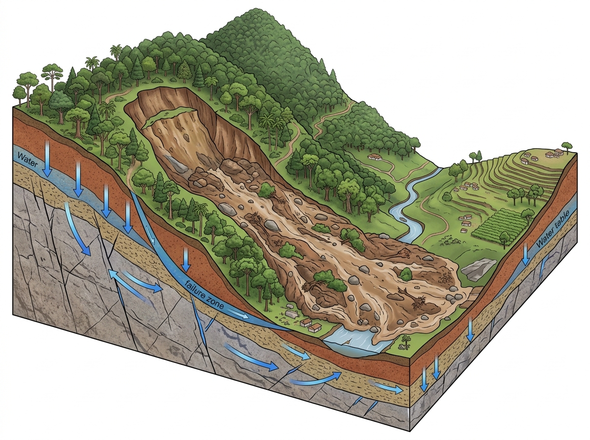
Extreme rainfallGeological weaknessesAnthropogenic pressuresGeomorphological factors✎ The 2024 Wayanad landslides exemplify how extreme rainfall interacts with pre-existing geological weaknesses (shear zones, weathered rock) and geomorphological features (narrow valleys) to trigger high-velocity debris flows…
Subject Relevance — Where This Topic Fits
- GS Paper I — Geography: Geomorphology, Climate Change and Disaster Management | GS Paper III — Environment and Disaster Management
- Prelims: Landslides, Western Ghats, Debris flow, Shear zones, Weathering, LiDAR, Geological mapping, Monsoon variability, Climate change and disasters, Punnapuzha river basin
- Essay: Climate Change and Geological Vulnerability: Lessons from the Wayanad Disaster, Disaster Management in India: Balancing Development and Environmental Conservation
Quick Revision: The 2024 Wayanad landslides exemplify how extreme rainfall interacts with pre-existing geological weaknesses (shear zones, weathered rock) and geomorphological features (narrow valleys) to trigger high-velocity debris flows, underscoring the need for integrated geological risk assessments in disaster management.
Why is this in the news?
The 2024 Wayanad landslides, triggered by extreme rainfall of 573 mm within 48 hours on July 30, 2024, resulted in catastrophic destruction due to the interplay of climatic extremes and pre-existing geological weaknesses. A peer-reviewed study published in *Landslides* journal by researchers from the University of Kerala, IISER Mohali, and Savitribai Phule Pune University highlights how structural geology, geomorphology, and anthropogenic pressures exacerbated the disaster, making it one of the most destructive in the Western Ghats. The findings underscore the urgent need for integrating geological risk assessments into disaster preparedness and climate adaptation strategies in ecologically fragile regions.
Background
- The Western Ghats, a UNESCO World Heritage Site, is a biodiversity hotspot and a critical water divide in peninsular India, but it is also highly susceptible to landslides due to its steep slopes, high rainfall, and complex geological structures.
- Kerala, particularly the Wayanad district, has experienced recurrent landslides, with major events in 2018, 2019, and 2020, highlighting the region’s vulnerability to extreme weather events linked to climate change.
- The 2024 Wayanad disaster occurred in the upper catchment of the Punnapuzha river, a tributary of the Kabani river, with the landslide crown located near Chooralmala and debris flow extending up to 8 km, devastating settlements like Punchirimattam and Mundakkai.
- Geological studies indicate that the region is underlain by ancient crystalline rocks (e.g., Charnockites, Khondalites) that have undergone multiple phases of deformation, creating planes of weakness such as shear zones, fractures, and foliations.
- The study utilised advanced techniques such as drone-mounted LiDAR, high-resolution aerial imagery, and laboratory analysis of rock samples to reconstruct the failure mechanism and assess post-disaster geomorphological changes.
Understanding Landslides: Mechanisms, Triggers, and Geological Controls in the Western Ghats
- Landslides are rapid mass movements of rock, soil, or debris down a slope, driven by gravitational forces and influenced by geological, hydrological, and anthropogenic factors; they are classified based on material type (rock, debris, earth) and movement type (falls, topples, slides, flows, spreads).
- Extreme rainfall is a primary trigger, but its impact is amplified by pre-existing geological weaknesses such as shear zones, fractures, and foliations in crystalline rocks, which act as conduits for water infiltration and zones of reduced shear strength.
- Weathering processes, particularly chemical weathering in tropical climates, transform hard rock into soft, clay-rich material over time, reducing slope stability and increasing susceptibility to failure during intense precipitation.
- Debris flows are a specific type of landslide where water-saturated debris moves rapidly downhill, often following pre-existing drainage channels or valleys, and can travel long distances, causing extensive damage to infrastructure and settlements.
- The Western Ghats’ geomorphology, characterised by steep escarpments, deep valleys, and high relief, facilitates the initiation and propagation of landslides, with narrow valleys acting as channels that accelerate debris flows.
- Structural geology plays a critical role: faults, thrusts, and joints in the rock mass create discontinuities that weaken slopes, while the orientation of these structures relative to slope dip determines the likelihood of failure.
- Advanced remote sensing techniques, such as LiDAR and high-resolution aerial imagery, are essential for mapping landslide-prone zones, monitoring slope instability, and designing early warning systems in high-risk regions.
Key Features
| Feature | Significance |
|---|---|
| Extreme rainfall (573 mm in 48 hours) | Triggered the initial slope failure by saturating the weathered rock mass, reducing shear strength and increasing pore water pressure. |
| Ancient crystalline rock formations | Underlie the region and have undergone prolonged deformation, creating shear zones and fractures that act as planes of weakness. |
| Highly weathered shear zone near the crown | Primary initiation point of the landslide due to extensive chemical weathering and water infiltration, leading to block detachment. |
| Narrow valley sections underlain by metagabbro | Act as constrictions that channelised the debris flow, increasing its velocity and destructive potential. |
| Debris flow travel distance (8 km) and descent (768 m) | Demonstrates the high mobility of the landslide, exacerbated by the steep gradient and valley morphology. |
Why it Matters
Geological and Geomorphological Insights
- Reinforces the necessity of integrating geological risk assessment into disaster management frameworks for landslide-prone regions like the Western Ghats.
- Highlights the role of long-term geological processes (e.g., deformation, weathering) in predisposing slopes to failure during extreme weather events.
- Demonstrates the importance of high-resolution mapping (LiDAR, aerial imagery) in identifying critical zones of instability in inaccessible terrains.
- Underscores the need for site-specific studies to understand the interplay between climate variability and geological structures in landslide susceptibility.
Disaster Management and Mitigation
- Exposes gaps in current early warning systems, which often rely solely on rainfall thresholds without accounting for geological vulnerabilities.
- Emphasises the need for real-time monitoring of pore water pressure and slope deformation in high-risk zones to predict imminent failures.
- Stresses the importance of structural mitigation measures (e.g., drainage systems, retaining walls) tailored to geological conditions rather than generic solutions.
- Calls for a multi-hazard approach in disaster planning, integrating landslide risks with other climate-induced hazards like floods and flash floods.
Policy and Governance
- Underscores the requirement for stricter enforcement of land-use regulations in ecologically sensitive and geologically fragile zones.
- Highlights the need for inter-departmental coordination between geological survey agencies, disaster management authorities, and local governments.
- Advocates for the inclusion of geological risk maps in urban planning and infrastructure development to prevent construction in high-hazard areas.
- Raises questions about the adequacy of existing compensation and rehabilitation policies for victims of climate-induced disasters.
Scientific Research and Education
- Demonstrates the value of collaborative research between universities and institutions in advancing understanding of landslide dynamics.
- Promotes the designation of landslide sites as geo-heritage locations to foster research, tourism, and public awareness about geological hazards.
- Encourages the integration of geological sciences into school and college curricula to build a cadre of professionals equipped to address such challenges.
Challenges
1. Inadequate Geological Risk Mapping
- Limited high-resolution geological and geomorphological data for many landslide-prone regions in India.
- Lack of standardised methodologies for integrating geological data with climate projections in risk assessments.
- Insufficient funding and technical capacity for systematic geological surveys in vulnerable areas.
UPSC Link: Geography: Landslides and Slope Stability
2. Gaps in Early Warning Systems
- Over-reliance on rainfall thresholds without accounting for geological predispositions to failure.
- Limited real-time monitoring of pore water pressure, slope deformation, and groundwater levels in high-risk zones.
- Inadequate dissemination of early warnings to vulnerable communities, particularly in remote areas.
UPSC Link: Disaster Management: Early Warning Systems
3. Land-Use Planning Failures
- Unregulated construction and agricultural activities in ecologically fragile and geologically unstable zones.
- Lack of enforcement of zoning regulations and building codes in landslide-prone areas.
- Insufficient consideration of geological hazards in urban and rural planning processes.
UPSC Link: Environmental Governance: Land-Use Planning
4. Limited Community Awareness and Preparedness
- Low awareness among local communities about geological hazards and their warning signs.
- Inadequate training and drills for disaster preparedness and response in vulnerable regions.
- Lack of community-based early warning systems tailored to local geological conditions.
UPSC Link: Disaster Management: Community Resilience
5. Institutional and Inter-Departmental Coordination
- Fragmented responsibilities among geological survey agencies, disaster management authorities, and local governments.
- Lack of a unified national framework for geological risk assessment and mitigation.
- Insufficient collaboration between research institutions and policy-making bodies.
UPSC Link: Governance: Inter-Departmental Coordination
6. Climate Change and Increasing Extreme Events
- Projected increase in the frequency and intensity of extreme rainfall events due to climate change.
- Need to incorporate climate projections into geological risk assessments for long-term planning.
- Challenges in adapting disaster management strategies to evolving climate patterns.
UPSC Link: Climate Change: Impacts and Adaptation
Challenges — UPSC Perspective
| Issue | Concern |
|---|---|
| Geological data gaps | Insufficient high-resolution geological and geomorphological data for risk assessment. |
| Early warning limitations | Over-reliance on rainfall thresholds without geological context. |
| Land-use planning failures | Unregulated construction in geologically unstable zones. |
| Community awareness deficits | Low preparedness and training for disaster response. |
| Institutional fragmentation | Lack of coordination among agencies responsible for risk mitigation. |
| Climate change adaptation | Need to integrate climate projections into geological risk assessments. |
Way Forward
- Conduct systematic geological and geomorphological mapping of landslide-prone regions using LiDAR and high-resolution aerial imagery to identify critical zones of instability.
- Develop multi-hazard early warning systems that integrate geological data (e.g., pore water pressure, slope deformation) with climate projections for real-time monitoring.
- Strengthen enforcement of land-use regulations and zoning laws in ecologically fragile and geologically unstable areas to prevent unregulated construction.
- Establish community-based early warning systems and conduct regular drills to enhance preparedness and response capabilities in vulnerable regions.
- Promote interdisciplinary research collaborations between geological survey agencies, academic institutions, and disaster management authorities to advance understanding of landslide dynamics.
- Integrate geological risk assessments into urban and rural planning processes to ensure infrastructure development is aligned with local geological conditions.
- Enhance public awareness campaigns to educate communities about geological hazards, their warning signs, and preparedness measures.
- Establish a national framework for geological risk mitigation that standardises methodologies and fosters inter-departmental coordination.
UPSC Value Addition
Keywords for Mains Answer-Writing
Wayanad landslides 2024 · Western Ghats geology · climate-geology interaction in disasters · debris flow dynamics · shear zones and slope failure · geological weathering · Punnapuzha river catchment · geo-heritage sites · landslide risk assessment · extreme rainfall and geological vulnerability
Concept Flow
Extreme rainfall (573 mm in 48 hours) → Saturation of weathered rock mass → Reduction in shear strength and increase in pore water pressure → Initiation of slope failure in highly weathered shear zone → Detachment of large rock block → High-speed debris flow down steep valley → Channelisation by narrow sections underlain by metagabbro → Destruction over 8 km and 768 m descent → Widespread damage in Punchirimattam, Mundakkai, and Chooralmala.
Prelims Practice Questions
Q1. Consider the following statements regarding the 2024 Wayanad landslides:
1. The disaster was triggered by extreme rainfall of nearly 573 mm within 48 hours.
2. The landslide originated within a highly weathered shear zone near the crown.
3. The debris flow travelled approximately 15 km before coming to a halt.
4. The affected region is underlain by ancient crystalline rocks with repeated deformation.
How many of the above statements are correct?
- Only one
- Only two
- Only three
- All
Answer: Only three — Statements 1, 2, and 4 are correct. Statement 3 is incorrect as the debris flow travelled nearly 8 km, not 15 km.
Q2. Assertion (A): The 2024 Wayanad landslides were solely caused by extreme rainfall.
Reason (R): Geological weaknesses such as shear zones and fractures played a critical role in determining the scale and impact of the landslide.
Options:
A. Both A and R are true, and R is the correct explanation of A.
B. Both A and R are true, but R is not the correct explanation of A.
C. A is true, but R is false.
D. A is false, but R is true.
- A
- B
- C
- D
Answer: D — Assertion (A) is false because the landslide was not solely caused by extreme rainfall; geological factors were equally critical. Reason (R) is true and correctly explains the geological role.
Q3. Match the following geological features with their descriptions:
Column I
1. Shear zone
2. Foliation
3. Metagabbro
4. Debris flow
Column II
A. A planar fabric in metamorphic rocks formed by the alignment of minerals.
B. A planar zone of deformed rock where displacement has occurred.
C. A type of metamorphic rock formed from gabbro.
D. A rapid downslope movement of rock, soil, and water.
Options:
1. 1-A, 2-B, 3-C, 4-D
2. 1-B, 2-A, 3-C, 4-D
3. 1-C, 2-A, 3-B, 4-D
4. 1-D, 2-B, 3-A, 4-C
- 1
- 2
- 3
- 4
Answer: 2 — Correct pairing: 1-B (Shear zone), 2-A (Foliation), 3-C (Metagabbro), 4-D (Debris flow).
Mains Practice Question
✍ The 2024 Wayanad landslides exemplify the interplay between extreme climatic events and geological vulnerabilities in disaster risk. Critically analyse the role of geological factors such as shear zones, weathering, and valley formations in amplifying the impact of such disasters. Also, discuss the measures required to mitigate such risks in ecologically sensitive regions like the Western Ghats. (15 Marks)
Approach: MODEL-ANSWER SKELETON:
1. **Introduction (2 marks)**: Define landslides and their classification (e.g., debris flow, rockslide). State the context of the 2024 Wayanad landslides as a case study highlighting the interplay of climate and geology.
2. **Geological factors amplifying impact (5 marks)**:
– **Shear zones and fractures**: Explain how ancient crystalline rocks in the Western Ghats have undergone repeated deformation, creating natural planes of weakness (cite the study’s findings on shear zones).
– **Chemical weathering**: Describe how prolonged rainwater infiltration transforms hard rock into soft, weathered material, reducing slope stability.
– **Valley formations**: Explain how narrow valley sections underlain by stronger rocks (e.g., metagabbro) channelised the debris flow, increasing its destructive potential.
– **Slope geometry**: Highlight the role of steep slopes and the 768-metre descent in accelerating the debris flow over 8 km.
3. **Climatic triggers (3 marks)**:
– Extreme rainfall (573 mm in 48 hours) as the immediate trigger, but its impact was magnified by pre-existing geological conditions.
– Reference the concept of ‘rainfall thresholds’ for landslide initiation in the Western Ghats.
4. **Mitigation measures (5 marks)**:
– **Early warning systems**: Discuss the need for real-time rainfall and slope stability monitoring (e.g., using LiDAR and remote sensing).
– **Land-use planning**: Emphasise restrictions on construction in high-risk zones, particularly in ecologically sensitive areas like the Western Ghats.
– **Afforestation and drainage management**: Highlight the role of vegetation in stabilising slopes and managing surface runoff.
– **Community awareness**: Stress the importance of training local communities in disaster preparedness and evacuation protocols.
– **Geo-heritage designation**: Discuss the proposal to designate the landslide site as a geo-heritage location for research and tourism, while ensuring controlled access to prevent further destabilisation.
5. **Conclusion (2 marks)**: Summarise the need for an integrated approach combining geological, hydrological, and socio-economic strategies to mitigate landslide risks in vulnerable regions.
Source: The Hindu
Generated by AanyaAi for educational purpose.

- हरियाणा सरकार ने गुरुग्राम में 24 मीटर चौड़ी सड़कों के लिए 1,158 एकड़ निजी भूमि अधिग्रहण करेगी - October 3, 2026
- Wildlife Corridors: Key to Survival for UPSC & State PCS Aspirants - October 3, 2026
- अमित शाह भोपाल में गौपालक सम्मेलन को संबोधित करेंगे, न्याय संहिता प्रदर्शनी का उद्घाटन - October 3, 2026

No Comments