


09 Sep New Greater Noida-Ganga Expressway Link: 30-45 Min Travel Time for UPSC Exams
✎ The proposed Greater Noida-Ganga Expressway link exemplifies integrated urban planning, where segregated freight and passenger corridors are essential to sustain economic growth while mitigating urban congestion.
Subject Relevance — Where This Topic Fits
- GS Paper II — Governance, Constitution and Polity (Urban Planning and Infrastructure Governance) | GS Paper III — Infrastructure: Energy, Ports, Roads, Airports and Railways
- Prelims: Multi-Modal Logistics Hub (MMLH), Dedicated Freight Corridors (DFC), Regional Connectivity, Urban Master Plan, Logistics Efficiency, Ganga Expressway, Noida International Airport (Jewar), Eastern Peripheral Expressway, Yamuna Expressway, Boraki Railway Station
- Essay: Infrastructure as a Catalyst for Regional Development, Balancing Economic Growth and Sustainable Urban Mobility
Quick Revision: The proposed Greater Noida-Ganga Expressway link exemplifies integrated urban planning, where segregated freight and passenger corridors are essential to sustain economic growth while mitigating urban congestion.
Why is this in the news?
The proposal for a new Greater Noida-Ganga Expressway link, aimed at reducing travel time to 30–45 minutes, has gained prominence due to the operationalisation of the Noida International Airport (Jewar) and the impending establishment of large-scale logistics and transport hubs in Greater Noida. This initiative underscores the need for integrated logistics planning to mitigate congestion and enhance regional connectivity.
Background
- The Noida International Airport (NIA) at Jewar, operational since June 2026, serves as a critical aviation gateway for the National Capital Region (NCR) and is expected to significantly increase both passenger and cargo traffic.
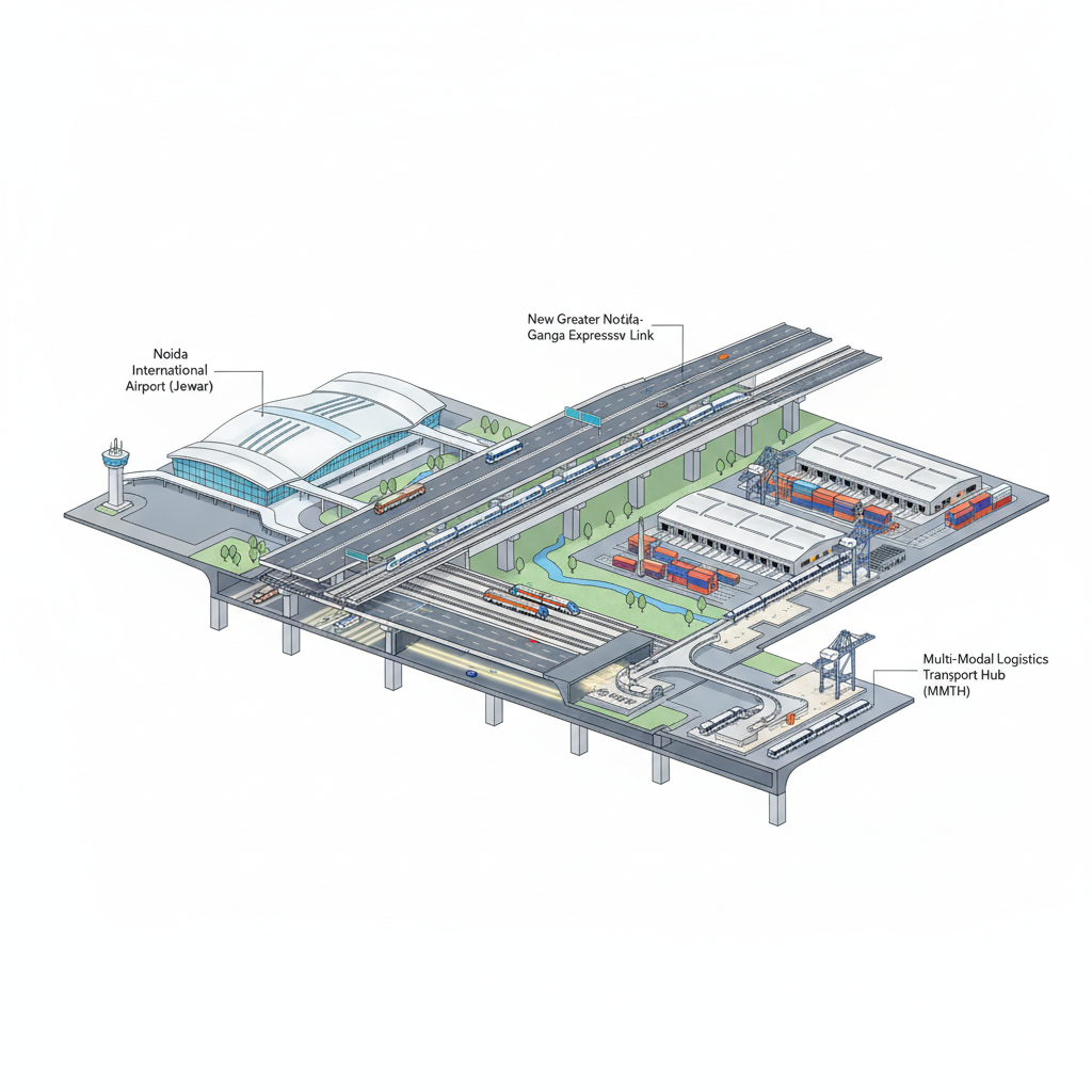
- Greater Noida is emerging as a key logistics and industrial hub, with the proposed 849-acre Multi-Modal Logistics Hub (MMLH) and the 360-acre Multi-Modal Transport Hub (MMTH) near Boraki Railway Station designed to integrate road, rail, and air transport.
- Existing expressways such as the Yamuna Expressway, Eastern Peripheral Expressway, and Dedicated Freight Corridors (DFC) currently serve the region, but their capacity is anticipated to be insufficient for the projected growth in freight and passenger traffic.
- The Greater Noida Industrial Development Authority (GNIDA) is revising its Master Plan 2041 to accommodate the anticipated surge in commercial and passenger mobility, with a focus on decongesting existing corridors.
- The Western Dedicated Freight Corridor (WDFC), parallel to the proposed elevated freight route, is a critical national infrastructure project aimed at enhancing freight movement efficiency across northern India.
What is the Proposed Greater Noida-Ganga Expressway Link?
- The GNIDA proposal includes a 105-metre-wide road connecting to the Hapur bypass, extending approximately 15 km to link with the Ganga Expressway, reducing travel time between Noida-Greater Noida and the Ganga Expressway to 30–45 minutes.
- A six-lane elevated road is proposed to connect the Multi-Modal Logistics Hub (MMLH) directly to the Noida International Airport’s cargo terminal, ensuring segregated movement of freight vehicles from passenger traffic.
- The elevated freight corridor is planned parallel to the Western Dedicated Freight Corridor (WDFC) to leverage existing freight infrastructure and minimise land acquisition and environmental impact.
- The initiative aims to distribute commercial vehicle traffic more efficiently, preventing congestion on roads primarily used by passenger vehicles and enhancing overall regional mobility.
- The proposed logistics hub (MMLH) will function as a dry port, integrating with major road networks and dedicated freight corridors, while the transport hub (MMTH) will consolidate interstate and local bus services, rail links, and future Mass Rapid Transit System (MRTS) connections.
Key Features
| Feature | Significance |
|---|---|
| 105-metre-wide arterial road connecting Hapur bypass and Ganga Expressway | Provides direct, high-capacity connectivity between Greater Noida, Noida, and the Ganga Expressway, reducing travel time to 30–45 minutes for freight and passenger traffic. |
| 15 km extension to Ganga Expressway | Integrates the proposed logistics corridor with a national expressway network, enhancing regional accessibility and reducing dependency on congested urban roads. |
| Six-lane elevated freight corridor parallel to Western Dedicated Freight Corridor | Ensures uninterrupted movement of goods between the Multi-Modal Logistics Hub (MMLH) and Noida International Airport’s cargo terminal, bypassing passenger traffic routes. |
| Dedicated freight infrastructure (elevated road) | Prevents competition for road space between passenger and commercial vehicles, improving safety and efficiency in mixed-use corridors. |
| Integration with Multi-Modal Logistics Hub (MMLH) and Multi-Modal Transport Hub (MMTH) | Facilitates seamless transfer of goods and passengers between road, rail, and air transport systems, supporting industrial and logistics growth in Greater Noida. |
Why it Matters
Economic
- Enhances the competitiveness of the National Capital Region (NCR) by improving connectivity between industrial hubs (Greater Noida, Noida) and national logistics corridors (Ganga Expressway, Dedicated Freight Corridors).
- Supports the operational efficiency of Noida International Airport (Jewar) by ensuring rapid cargo movement, thereby attracting more air freight and logistics investments.
- Strengthens the role of Greater Noida as a logistics and industrial centre by providing dedicated freight infrastructure, reducing transit costs and delays.
Urban Planning and Infrastructure
- Promotes sustainable urban mobility by segregating freight and passenger traffic, reducing congestion and pollution in mixed-use corridors.
- Aligns with the principles of Transit-Oriented Development (TOD) by integrating transport hubs (airport, logistics hub, MMTH) with high-capacity road networks.
- Supports the objectives of the Greater Noida Master Plan 2041 by accommodating projected growth in industrial and logistics activities.
Strategic Connectivity
- Integrates regional expressways (Yamuna Expressway, Eastern Peripheral Expressway, Ganga Expressway) into a cohesive network, improving inter-state and intra-regional connectivity.
- Enhances the accessibility of the NCR to eastern and northern India via the Ganga Expressway, facilitating trade and economic integration.
- Reduces reliance on congested urban roads (e.g., Delhi-Noida-Delhi Expressway) by providing alternative freight routes.
Logistics and Supply Chain
- Facilitates the development of a dry port at the Multi-Modal Logistics Hub (MMLH), enabling efficient cargo consolidation, storage, and distribution.
- Supports the integration of air cargo with road and rail networks, reducing transit times and improving supply chain resilience.
- Contributes to the operationalization of the Western Dedicated Freight Corridor by providing last-mile connectivity to logistics hubs.
Challenges
1. Land Acquisition and Right-of-Way
- Acquisition of land for the 105-metre-wide arterial road and elevated freight corridor may face resistance from landowners and local communities.
- Ensuring adequate right-of-way for the six-lane elevated road, particularly in densely populated or industrial areas, could be a procedural and legal challenge.
UPSC Link: Land Acquisition Act, 2013
2. Environmental and Ecological Concerns
- Construction of elevated roads and expressway linkages may impact local ecosystems, including wetlands and green belts, necessitating environmental impact assessments (EIAs).
- Increased vehicular traffic, even if segregated, could contribute to air and noise pollution, requiring mitigation measures such as green barriers or noise screens.
UPSC Link: Environmental Impact Assessment Notification, 2006
3. Traffic Management and Safety
- Ensuring seamless integration of the new freight corridor with existing roads (e.g., Hapur bypass, Yamuna Expressway) to avoid bottlenecks and accidents.
- Managing the transition phase during construction, where temporary diversions and lane closures may disrupt traffic flow.
UPSC Link: Motor Vehicles Act, 1988
4. Funding and Financial Viability
- Securing adequate funding for the construction and maintenance of the elevated freight corridor and expressway linkages, particularly given the scale of infrastructure required.
- Ensuring cost recovery through user charges or public-private partnerships (PPPs) to maintain financial sustainability.
UPSC Link: Public-Private Partnership Policy, 2015
5. Coordination Among Agencies
- Facilitating coordination between GNIDA, Uttar Pradesh State Highway Authority, National Highways Authority of India (NHAI), and other stakeholders to ensure alignment of plans and timelines.
- Harmonising the proposed infrastructure with existing and planned projects such as the Delhi-Varanasi High Speed Rail and regional metro networks.
UPSC Link: Inter-State Council
Challenges — UPSC Perspective
| Issue | Concern |
|---|---|
| Land acquisition delays | Potential resistance from landowners, leading to legal disputes and project delays. |
| Environmental clearances | Requirement for comprehensive EIAs and compliance with environmental norms, which may prolong approval processes. |
| Traffic diversion during construction | Risk of congestion and accidents due to temporary road closures and diversions. |
| Funding gaps | Need for innovative financing models (PPPs, toll revenues) to ensure long-term viability. |
| Inter-agency coordination | Ensuring seamless integration with existing transport networks and avoiding duplication of efforts. |
Way Forward
- Conduct detailed feasibility studies and environmental impact assessments (EIAs) for the proposed road and elevated freight corridor to address ecological and social concerns.
- Initiate land acquisition processes under the Right to Fair Compensation and Transparency in Land Acquisition, Rehabilitation and Resettlement (LARR) Act, 2013, with transparent compensation mechanisms.
- Develop a phased construction plan to minimise traffic disruptions, including temporary diversions and public awareness campaigns.
- Explore public-private partnership (PPP) models for funding and maintaining the elevated freight corridor, leveraging toll revenues and user charges.
- Establish a dedicated project monitoring committee comprising representatives from GNIDA, NHAI, UPSHA, and local authorities to ensure timely execution and coordination.
- Integrate the proposed infrastructure with existing transport hubs (Noida International Airport, MMLH, MMTH) through multi-modal connectivity plans, including last-mile solutions.
- Implement traffic management systems (e.g., intelligent transport systems, variable message signs) to optimise flow and enhance safety on the new corridors.
UPSC Value Addition
Keywords for Mains Answer-Writing
Multi-Modal Logistics Hub (MMLH) · Multi-Modal Transport Hub (MMTH) · Dedicated Freight Corridor · regional connectivity · logistics infrastructure · passenger-freight segregation · Master Plan 2041 · regional economic corridors · urban transport planning · sustainable logistics · expressway networks · Jewar Noida International Airport · Greater Noida Industrial Development Authority (GNIDA) · regional development · transport policy · regional integration
Concept Flow
Noida International Airport (Jewar) operationalisation → Increased cargo and passenger traffic → Congestion on existing roads → GNIDA proposes dedicated freight and passenger corridors → Master Plan 2041 revision → Land acquisition and environmental clearances → Construction of 105-metre-wide road and elevated freight corridor → Integration with Ganga Expressway and Dedicated Freight Corridors → Reduced travel time and improved logistics efficiency.
Prelims Practice Questions
Q1. Consider the following statements regarding the Multi-Modal Logistics Hub (MMLH) proposed in Greater Noida:
1. The MMLH is envisaged as a dry port with direct links to major roads and dedicated freight corridors.
2. The hub will function primarily as a passenger transport terminal.
3. The proposed six-lane elevated road connecting MMLH to Jewar airport’s cargo terminal will run parallel to the Western Dedicated Freight Corridor.
How many of the above statements are correct?
- Only one
- Only two
- All three
- None
Answer: All three — Statement 1 and 3 are correct. Statement 2 is incorrect as the MMLH is focused on freight, not passenger transport.
Q2. Assertion (A): The proposed Greater Noida-Ganga Expressway link aims to reduce travel time between Noida-Greater Noida and the Ganga Expressway to 30-45 minutes.
Reason (R): The link is designed to facilitate seamless passenger and freight movement without segregation of traffic.
- Both A and R are true, and R is the correct explanation of A
- Both A and R are true, but R is not the correct explanation of A
- A is true, but R is false
- A is false, but R is true
Answer: A is true, but R is false — Assertion (A) is true as the proposed link aims to reduce travel time. Reason (R) is true but incorrect as the primary aim is to segregate passenger and freight traffic, not to facilitate seamless movement of both.
Mains Practice Question
✍ The integration of passenger and freight transport infrastructure is critical for sustainable regional development. Critically analyse the proposed Greater Noida-Ganga Expressway link and the Multi-Modal Logistics Hub (MMLH) in this context. Also, examine the role of the Greater Noida Industrial Development Authority (GNIDA) in this planning process. (15 Marks)
Approach: MODEL-ANSWER SKELETON:
1. **Context and Rationale** (3 Marks):
– Explain the need for segregated passenger and freight transport infrastructure in rapidly urbanising regions like Greater Noida.
– Reference the opening of the Jewar Noida International Airport and the proposed MMLH/MMTH as drivers of increased traffic.
2. **Proposed Infrastructure** (4 Marks):
– Detail the proposed 105-metre-wide road connecting to the Hapur bypass and extending 15 km to the Ganga Expressway.
– Describe the six-lane elevated road parallel to the Western Dedicated Freight Corridor linking MMLH to the airport’s cargo terminal.
– Highlight the objective of reducing travel time to 30-45 minutes and segregating freight from passenger traffic.
3. **Role of GNIDA** (3 Marks):
– Explain GNIDA’s mandate under the Master Plan 2041 and its authority to propose amendments.
– Discuss the process of public consultation, approval, and notification for the proposed changes.
– Reference the recent presentation to the Industrial Development Minister and the likelihood of a notification post-review.
4. **Challenges and Critique** (3 Marks):
– Analyse potential challenges: land acquisition, environmental concerns, coordination with other agencies (e.g., NHAI, DFC), and cost implications.
– Critique the feasibility of complete segregation of passenger and freight traffic in a mixed-use urban corridor.
– Discuss the long-term sustainability of such infrastructure in balancing economic growth and environmental impact.
5. **Broader Implications** (2 Marks):
– Link the proposal to broader national policies on logistics infrastructure (e.g., National Logistics Policy, Sagarmala, Bharatmala).
– Highlight the role of such initiatives in enhancing regional integration and economic competitiveness.
Source: The Indian Express
Uttar Pradesh PCS (UPPSC) — State PCS Practice
Prelims: The proposed New Greater Noida-Ganga Expressway link aims to reduce travel time between the two regions to approximately how many minutes?
- 15-30 minutes
- 30-45 minutes
- 45-60 minutes
- 60-90 minutes
Answer: 30-45 minutes — The proposed expressway link is designed to cut travel time between New Greater Noida and the Ganga region to 30-45 minutes, enhancing connectivity for commuters and logistics.
Mains: Discuss the potential economic and administrative benefits of the proposed New Greater Noida-Ganga Expressway link for Uttar Pradesh, with a focus on regional development, industrial growth, and urban-rural integration. (200 words)
Generated by AanyaAi for educational purpose.
Related guides on our sites
- Current affairs for upsc 2026
- How to prepare for GS paper 1 for UPSC CSE mains exam
- Best UPSC coaching for IFOS exam
- Best geography optional coaching

- UPSC Civil Services (Main) Examination 2026 — Geology Optional Paper I: Question Paper | Plutus IAS - September 21, 2026
- विशेष अभियान 6: रेलवे में लंबित मामलों के निपटान और स्वच्छता को संस्थागत रूप देने की तैयारी शुरू, जानिए पूरी योजना - September 21, 2026
- Railway Special Campaign 6: Key Focus Areas for UPSC & State PCS 2026 - September 21, 2026

No Comments