


27 Oct Cyclone Arnab: Key Facts for UPSC & State PCS Geography Preparation
✎ The IMD classifies cyclones into five categories based on wind speed, with Very Severe Cyclonic Storms (118–165 kmph) requiring immediate evacuation and deployment of disaster response forces.
Subject Relevance — Where This Topic Fits
- GS Paper III — Disaster Management | GS Paper I — Geophysical Phenomena and their Impact on Human Settlements
- Prelims: Cyclone classification (IMD), Doppler Weather Radar, National Disaster Management Authority (NDMA), State Disaster Management Authorities (SDMAs), Storm Surge, Coastal Erosion, IMD bulletins, Manamitra Helpline, Tropical Cyclone Risk Mitigation and Preparedness (TCRMP) framework
- Essay: Climate change and increasing frequency of extreme weather events in India: Challenges and policy responses, Role of technology in disaster risk reduction: From early warning systems to community resilience
Quick Revision: The IMD classifies cyclones into five categories based on wind speed, with Very Severe Cyclonic Storms (118–165 kmph) requiring immediate evacuation and deployment of disaster response forces.
Why is this in the news?
Cyclone ‘Arnab’, classified as a Very Severe Cyclonic Storm by the India Meteorological Department (IMD), is currently tracking towards the Andhra Pradesh coast with sustained wind speeds of 115–125 kmph, gusting up to 140 kmph. Expected to make landfall near Yanam between Bapatla and Visakhapatnam by the forenoon of 28 October 2026, the cyclone has already initiated heavy rainfall and strong winds in North Andhra districts, prompting large-scale preparedness measures by state disaster management authorities. The event underscores the operational challenges in tropical cyclone forecasting, early warning dissemination, and multi-state coordination in disaster response.
Background
- Tropical cyclones are intense low-pressure systems that form over warm ocean waters, primarily in the Bay of Bengal and Arabian Sea, during the pre-monsoon (April–May) and post-monsoon (October–December) seasons in India.
- The IMD classifies cyclones based on maximum sustained surface wind speeds: Cyclonic Storm (62–87 kmph), Severe Cyclonic Storm (88–117 kmph), Very Severe Cyclonic Storm (118–165 kmph), and Extremely Severe Cyclonic Storm (166–221 kmph).
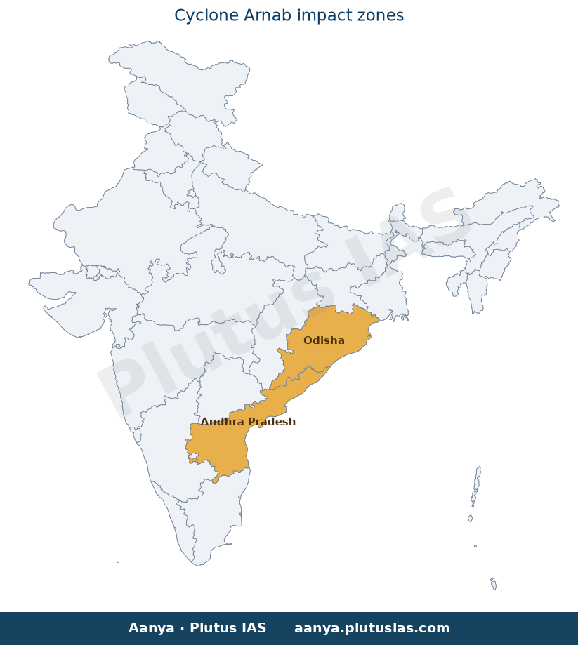
- India’s eastern coast, particularly Andhra Pradesh and Odisha, is highly vulnerable to cyclones due to its geographical configuration, shallow continental shelf, and high population density in coastal districts.
- The National Disaster Management Act, 2005, and the National Policy on Disaster Management, 2009, provide the statutory framework for disaster risk reduction in India, mandating the establishment of National Disaster Management Authority (NDMA), State Disaster Management Authorities (SDMAs), and District Disaster Management Authorities (DDMAs).
- The IMD operates a network of Doppler Weather Radars across coastal regions to track cyclonic systems, providing real-time data on intensity, movement, and landfall timing.
- India’s cyclone preparedness framework includes the issuance of colour-coded alerts (Yellow, Orange, Red), evacuation protocols, and the deployment of National Disaster Response Force (NDRF) and State Disaster Response Force (SDRF) units.
What is a Tropical Cyclone?
- A tropical cyclone is a rapidly rotating storm system characterised by a low-pressure centre, a closed low-level atmospheric circulation, strong winds, and a spiral arrangement of thunderstorms that produce heavy rain.
- Cyclones derive their energy from the warm ocean surface, typically requiring sea surface temperatures of at least 26.5°C to intensify, which is prevalent in the Bay of Bengal during the post-monsoon season.
- The structure of a tropical cyclone includes the eye (a calm central region), the eyewall (where the most intense winds and rainfall occur), and rainbands (spiral bands of thunderstorms extending outward).
- Cyclones are classified based on wind speed, with the IMD’s classification ranging from Cyclonic Storm to Super Cyclonic Storm, each category triggering specific response protocols.
- The Coriolis effect, resulting from Earth’s rotation, is essential for cyclone formation, which is why cyclones do not form within 5° of the equator where the Coriolis force is negligible.
- Storm surge, a rise in sea level caused by the cyclone’s winds and low pressure, is the deadliest aspect of tropical cyclones, often leading to coastal flooding and erosion, as observed in Kakinada district during Cyclone ‘Arnab’.
- The IMD’s cyclone warning system includes four stages: (1) Cyclone Watch (48 hours before landfall), (2) Cyclone Alert (24 hours before landfall), (3) Cyclone Warning (12 hours before landfall), and (4) Post-Landfall Outlook (for residual impact).
Key Features
| Feature | Significance |
|---|---|
| Cyclone intensity and trajectory | The Very Severe Cyclonic Storm ‘Arnab’ is projected to make landfall between Bapatla and Visakhapatnam with maximum sustained winds of 115–125 kmph, gusting to 140 kmph, posing significant risks to coastal infrastructure and human settlements. |
| IMD monitoring and forecasting | The India Meteorological Department (IMD) employs Doppler Weather Radar at Visakhapatnam for continuous surveillance, enabling accurate tracking and timely dissemination of warnings to disaster management authorities. |
| State Disaster Response Mechanisms | The Andhra Pradesh State Disaster Management Authority (APSDMA) has activated emergency protocols, including public advisories via WhatsApp (Manamitra service) and coastal beach closures, to mitigate impact. |
| Coastal erosion and infrastructure damage | Preliminary reports indicate coastal erosion at Uppada beach (Kakinada district), with boulders displaced onto roads, disrupting transport and necessitating precautionary measures. |
| Multi-state preparedness | Odisha remains on alert, with the system expected to influence weather patterns in the region, requiring inter-state coordination for resource deployment and evacuation. |
Why it Matters
Disaster Risk Reduction (DRR) and Governance
- Demonstrates the operationalisation of the Sendai Framework for Disaster Risk Reduction (2015–2030), particularly Target E: ‘Substantially increase the availability of and access to multi-hazard early warning systems and disaster risk information by 2030.’
- Highlights the role of the National Disaster Management Authority (NDMA) and state DMAs in implementing the Disaster Management Act, 2005, through pre-emptive evacuation and shelter management.
Meteorological Science and Public Safety
- Showcases the application of Doppler Weather Radar technology in real-time cyclone tracking, a critical component of the IMD’s mandate under the Indian Meteorological Department Act, 1975.
- Illustrates the importance of accurate weather forecasting in reducing loss of life and property, aligning with the National Policy on Disaster Management (2009).
Infrastructure Resilience and Climate Adaptation
- Exposes vulnerabilities in coastal infrastructure, including erosion-prone beaches and inadequate coastal protection measures, necessitating long-term climate-resilient planning.
Inter-state Coordination and Federalism
- Emphasises the need for seamless coordination between state governments (Andhra Pradesh and Odisha) and central agencies (IMD, NDMA) for resource mobilisation and disaster response.
Challenges
1. Early Warning Dissemination
- Risk of delayed or incomplete dissemination of cyclone warnings to vulnerable communities, particularly in remote coastal areas.
- Dependence on digital platforms (e.g., WhatsApp) may exclude populations with limited internet access.
UPSC Link: GS-III: Disaster Management
2. Coastal Infrastructure Vulnerability
- High susceptibility of coastal roads, beaches, and settlements to erosion and storm surges, exacerbated by climate change.
- Inadequate pre-emptive retrofitting of critical infrastructure (e.g., ports, power lines) to withstand cyclonic winds.
UPSC Link: GS-III: Infrastructure
3. Evacuation and Shelter Management
- Logistical challenges in evacuating populations from low-lying areas within the short warning window (24–48 hours).
- Overcrowding in cyclone shelters due to inadequate capacity or accessibility issues.
UPSC Link: GS-III: Disaster Management
4. Post-Disaster Recovery and Rehabilitation
- Delayed restoration of essential services (electricity, water, connectivity) due to logistical constraints.
- Risk of secondary disasters (e.g., waterborne diseases, landslides) in the aftermath of cyclone landfall.
UPSC Link: GS-III: Disaster Management
5. Climate Change Amplification
- Increasing frequency and intensity of cyclones in the Bay of Bengal, linked to global warming and ocean warming trends.
- Need for integrating climate projections into long-term coastal zone management plans.
UPSC Link: GS-III: Environment
Challenges — UPSC Perspective
| Issue | Concern |
|---|---|
| Warning dissemination gaps | Risk of miscommunication or delayed alerts in remote coastal hamlets. |
| Shelter capacity constraints | Insufficient cyclone shelters to accommodate displaced populations. |
| Infrastructure fragility | Coastal roads and buildings vulnerable to storm surges and wind damage. |
| Inter-state resource allocation | Potential delays in deploying NDRF teams or relief materials across state borders. |
| Post-disaster health risks | Outbreak of diseases due to contaminated water sources and disrupted sanitation. |
| Climate change feedback | Long-term increase in cyclone intensity requiring adaptive governance frameworks. |
Way Forward
- Strengthen Doppler Weather Radar network in cyclone-prone coastal districts to enhance forecast accuracy and lead time.
- Expand multi-channel warning dissemination (SMS, sirens, community radio) to cover all vulnerable segments, including fisherfolk communities.
- Conduct pre-cyclone mock drills and evacuation simulations in collaboration with local self-governments (Panchayats/Municipalities).
- Invest in climate-resilient coastal infrastructure, including elevated roads, storm-resistant housing, and mangrove restoration.
- Establish rapid-response teams for post-cyclone debris clearance and infrastructure repair in coordination with municipal corporations.
- Integrate climate projections into the State Action Plans on Climate Change (SAPCC) to address long-term cyclone risks.
- Enhance inter-state disaster response protocols under the National Disaster Response Force (NDRF) for seamless deployment.
- Promote community-based disaster preparedness through training in first aid, search-and-rescue, and early warning interpretation.
UPSC Value Addition
Keywords for Mains Answer-Writing
Cyclone ‘Arnab’, Bay of Bengal, Very Severe Cyclonic Storm, India Meteorological Department (IMD), Disaster Management Act 2005, National Disaster Management Authority (NDMA), State Disaster Management Authorities (SDMAs), Doppler Weather Radar, Cyclone Warning Dissemination System, Coastal Vulnerability, Disaster Preparedness, National Cyclone Risk Mitigation Project (NCRMP), Sendai Framework for Disaster Risk Reduction · Cyclone tracking, IMD classification of cyclones, Tropical Cyclone, Cyclone warning protocols, Disaster response mechanisms, Coastal erosion mitigation, Multi-hazard early warning systems, Climate change and extreme weather events
Concept Flow
Bay of Bengal cyclogenesis → IMD monitoring via Doppler radar → IMD issues cyclone warnings → State DMAs activate disaster response protocols → Public advisories issued (e.g., beach closures, WhatsApp alerts) → Cyclone landfall with high winds and heavy rainfall → Coastal erosion and infrastructure damage → Post-landfall recovery and rehabilitation → Integration of climate projections into long-term coastal governance.
Prelims Practice Questions
Q1. Consider the following statements regarding the classification of cyclones by the India Meteorological Department (IMD):
1. A ‘Very Severe Cyclonic Storm’ is classified when wind speeds range between 118-165 km/h.
2. Cyclone ‘Arnab’ has been classified as a ‘Very Severe Cyclonic Storm’ as per IMD.
3. The IMD uses the Saffir-Simpson Hurricane Wind Scale for classifying cyclones in the Indian Ocean region.
4. A ‘Severe Cyclonic Storm’ has wind speeds between 89-117 km/h.
How many of the above statements are correct?
- Only one
- Only two
- Only three
- All four
Answer: Only three — Statements 1, 2, and 4 are correct. IMD classifies cyclones based on wind speeds, with ‘Very Severe Cyclonic Storm’ having wind speeds of 118-165 km/h and ‘Severe Cyclonic Storm’ having 89-117 km/h. Statement 3 is incorrect as IMD does not use the Saffir-Simpson scale; it uses its own classification system.
Q2. Assertion (A): The Doppler Weather Radar at Visakhapatnam is used for tracking the intensity and movement of cyclones like ‘Arnab’.
Reason (R): Doppler Weather Radars provide real-time data on wind speed, direction, and precipitation, which is critical for cyclone forecasting and early warning systems.
- Both A and R are true, and R is the correct explanation of A.
- Both A and R are true, but R is not the correct explanation of A.
- A is true, but R is false.
- A is false, but R is true.
Answer: Both A and R are true, and R is the correct explanation of A. — Both the assertion and reason are true. Doppler Weather Radars are indeed used for tracking cyclones, and the reason correctly explains how they function in cyclone forecasting and early warning systems.
Q3. Match the following columns related to disaster management in India:
Column I (Institution/Scheme) | Column II (Purpose/Function)
——————————-|——————————-
A. National Disaster Management Authority (NDMA) | 1. Provides financial assistance to states for disaster management projects
B. State Disaster Management Authority (SDMA) | 2. Formulates policies and plans for disaster management at the national level
C. National Cyclone Risk Mitigation Project (NCRMP) | 3. Implements disaster management plans at the state level
D. Cyclone Warning Dissemination System (CWDS) | 4. Issues early warnings for cyclones and disseminates them to the public
Select the correct match:
- A-2, B-3, C-1, D-4
- A-1, B-2, C-4, D-3
- A-3, B-1, C-2, D-4
- A-4, B-3, C-1, D-2
Answer: A-2, B-3, C-1, D-4 — The correct matches are: A-2 (NDMA formulates national policies), B-3 (SDMA implements plans at the state level), C-1 (NCRMP provides financial assistance), and D-4 (CWDS issues and disseminates cyclone warnings).
Mains Practice Question
✍ The frequency and intensity of tropical cyclones in the Bay of Bengal have been increasing in recent years, posing significant challenges to coastal states like Andhra Pradesh and Odisha. In this context, critically examine the institutional and policy frameworks in India for cyclone preparedness and response. Also, evaluate the effectiveness of these frameworks in mitigating the impact of cyclones like ‘Arnab’. (15 Marks)
Approach: MODEL-ANSWER SKELETON:
1. **Institutional Framework**:
– **National Level**: Role of the National Disaster Management Authority (NDMA) under the Disaster Management Act 2005, including policy formulation (NDMP 2019), coordination with IMD, and oversight of National Cyclone Risk Mitigation Project (NCRMP).
– **State Level**: Functions of State Disaster Management Authorities (SDMAs) in Andhra Pradesh and Odisha, including implementation of state-specific disaster management plans and coordination with district authorities.
– **Local Level**: Role of District Disaster Management Authorities (DDMAs) and community-based disaster preparedness (e.g., training of volunteers, mock drills).
2. **Policy and Legislative Framework**:
– **Disaster Management Act 2005**: Legal basis for institutional arrangements, including the creation of NDMA, SDMAs, and DDMAs.
– **National Cyclone Risk Mitigation Project (NCRMP)**: Phases, objectives (e.g., coastal protection, early warning systems), and funding (World Bank assistance).
– **Sendai Framework for Disaster Risk Reduction (2015-2030)**: India’s commitment to reducing disaster risk and building resilience.
3. **Early Warning and Dissemination Systems**:
– Role of the India Meteorological Department (IMD) in cyclone tracking, classification (e.g., Very Severe Cyclonic Storm), and issuance of warnings.
– Cyclone Warning Dissemination System (CWDS) and its components (e.g., satellite-based communication, mobile alerts, community radio).
– Use of Doppler Weather Radars (e.g., Visakhapatnam) for real-time monitoring of cyclones like ‘Arnab’.
4. **Challenges and Gaps**:
– **Institutional Coordination**: Issues in inter-state coordination (e.g., Andhra Pradesh-Odisha) and between central and state agencies.
– **Resource Constraints**: Limitations in funding, infrastructure (e.g., cyclone shelters, evacuation routes), and manpower.
– **Community Preparedness**: Gaps in awareness, training, and participation of local communities in disaster response.
– **Climate Change**: Increasing frequency and intensity of cyclones due to climate change, necessitating adaptive strategies.
5. **Effectiveness and Way Forward**:
– **Successes**: Examples of effective cyclone management (e.g., Cyclone Fani 2019, Cyclone Yaas 2021) and lessons learned.
– **Recommendations**: Strengthening early warning systems, improving infrastructure (e.g., coastal embankments, evacuation routes), enhancing community resilience, and integrating climate change adaptation into disaster management plans.
6. **Conclusion**:
– Summarize the strengths and weaknesses of India’s cyclone preparedness framework.
– Emphasize the need for a multi-hazard approach, technological integration, and sustainable financing to address future challenges.
Source: orissapost.com
Odisha PCS (OPSC (OAS)) — State PCS Practice
Prelims: Cyclone ‘Arnab’ is expected to make landfall near which coastal district of Andhra Pradesh, prompting Odisha to remain on high alert?
- A. Srikakulam
- B. Visakhapatnam
- C. Nellore
- D. Guntur
Answer: A. Srikakulam — Cyclone ‘Arnab’ is projected to cross the Andhra Pradesh coast near Srikakulam district, necessitating preparedness measures in Odisha due to shared coastal vulnerability.
Mains: Examine the socio-economic and ecological impacts of frequent cyclonic disturbances in coastal Odisha, with special reference to disaster preparedness and mitigation strategies adopted by the state government.
Generated by AanyaAi for educational purpose.
Related guides on our sites
- How to prepare for GS paper 1 for UPSC CSE mains exam
- Best UPSC coaching for IFOS exam
- Best geography optional coaching
- Best geography optional coaching

- Cyclone Arnab: Key Facts for UPSC & State PCS Geography Preparation - October 27, 2026
- चक्रवात ‘अर्नब’: आईएमडी ने बढ़ाई गति, जानिए लैंडफॉल और तैयारी - October 27, 2026
- केंद्रीय सतर्कता आयोग द्वारा सतर्कता जागरूकता सप्ताह 2026 मनाया जाएगा - October 27, 2026

No Comments