
25 Sep Balancing Maritime Defence with Island Ecology: The Great Nicobar Dilemma
This article covers “Daily Current Affairs” and Topic details Balancing Maritime Defence with Island Ecology: The Great Nicobar Dilemma
SYLLABUS MAPPING:
GS-3- Environment- Balancing Maritime Defence with Island Ecology: The Great Nicobar Dilemma
FOR PRELIMS
What is the Great Nicobar Project, and why has it been in the news recently?
FOR MAINS
What are the major ecological concerns linked with the Great Nicobar Project?
Why in the News?
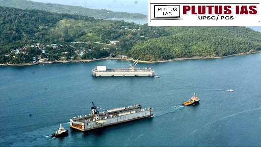
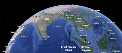
The Great Nicobar Project (Holistic Development of Great Nicobar Island), approved by the Union Cabinet in 2021, has once again come into focus due to its immense economic and defence potential, alongside serious ecological and indigenous concerns. Valued at around ₹72,000 crore, the project envisages the development of a transshipment port, airport, power plant, and township, spread over 166 sq. km, which accounts for nearly 10% of the island’s area. While the government highlights its strategic importance in enhancing connectivity and national security, political leaders, environmentalists, and experts remain sharply divided, debating whether the long-term economic and defence gains outweigh the risks posed to biodiversity, fragile ecosystems, and the rights of indigenous communities.
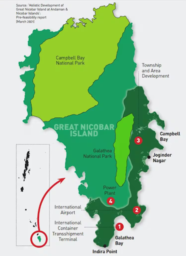
What is the Great Nicobar Project?
Implemented by Andaman & Nicobar Islands Integrated Development Corporation (ANIIDCO).
Spread over 30 years, phased construction beginning in 2024, partial operation by 2028.
Four Main Components:
1. Transshipment Port at Galathea Bay (14.5 million TEUs capacity)
2. Greenfield International Airport (3,300-metre runway for wide-body aircraft).
3. 450 MW Power Plant (gas + solar).
4. 16,569-hectare Township (for ~65,000 residents, workers, and migrants).
Significance of the Project
| Dimension | Significance (with Data/Examples) |
|---|---|
| Strategic Location | Island lies near the Malacca Strait, through which ~25% of global trade and 80% of China’s oil imports pass. Gives India a maritime chokepoint advantage. |
| Economic Growth | Expected to generate ₹30,000 crore annually by 2040 and create 50,000 jobs. Supports national initiatives like Sagarmala. |
| Port Infrastructure | A transshipment hub at Galathea Bay is planned to handle 14.5 million TEUs/year, positioning India as a competitor to Singapore and Malaysia. |
| Connectivity Boost | The development of an international airport will enhance tourism and make Great Nicobar a regional logistics hub. |
| Energy Self-Sufficiency | A 450 MW power plant (gas + solar) will meet industrial and civilian energy demand, ensuring self-reliance. |
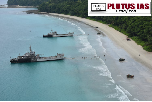
| Defence & Security | Strengthens India’s presence in the Indo-Pacific and improves surveillance over Sunda, Lombok, and Ombai-Wetar straits. |
| Regional Integration | Can emerge as a growth pole for BIMSTEC, boosting trade and connectivity with Southeast Asia. |
Concerns of Such Mega Projects
1. Ecological Concerns
| Issue | Example / Impact |
|---|---|
| Loss of Biodiversity | Island is home to 200 bird species and endemic flora covering ~85% of land, risking irreversible ecological damage. |
| Threat to Leatherback Turtles | Galathea Bay is the world’s most important nesting site for the giant leatherback turtle, which faces extinction risks. |
| Coral Reef & Seabed Destruction | Large-scale dredging for the port may destroy coral reefs, which support hundreds of fish species and marine livelihoods. |
2. Indigenous & Social Concerns
| Issue | Example / Impact |
|---|---|
| Displacement of Shompen Tribe (PVTG) | With a population of just 300–400, the tribe risks losing ~130 sq. km of ancestral land. |
| Health Risks | Uncontacted tribes are highly vulnerable to diseases like measles and flu, which historically have very high mortality rates. |
| Cultural Erosion | Sacred tribal sites and traditional knowledge systems could be lost permanently, weakening indigenous identity. |
3. Legal & Governance Concerns
| Issue | Example / Impact |
|---|---|
| Violation of CRZ (Coastal Regulation Zone – 1A) | CRZ laws prohibit development in ecologically fragile areas, yet clearances were granted. |
| Questionable Environmental Clearances | The MoEFCC granted clearance despite objections from environmental experts and civil society. |
| Disaster Risks | The island lies in a seismic and tsunami-prone zone; the 2004 tsunami killed thousands, highlighting high disaster vulnerability. |
Way Forward: Balancing Development & Ecology
1. Strategic Phasing: Prioritise defence & port infrastructure, while delaying large-scale township expansion until ecological safeguards are ensured.
2. Eco-Sensitive Development: Use green construction technologies, renewable energy, and limit dredging.
3. Community-Centric Approach: Respect rights of Shompen & Nicobarese tribes; include them in decision-making and livelihood generation.
4. Environmental Safeguards: Independent monitoring of impacts on turtles, corals, and forests with mitigation plans.
5. International Best Practices: Learn from Singapore’s land-use balance and Costa Rica’s eco-tourism for sustainable development.
6. Legal Compliance: Strict adherence to CRZ laws and Supreme Court guidelines on tribal protection.
Global Examples of Balancing Development, Ecology & Security
| Project / Location | Ecological Security Role | National Security Benefit | Management / Balanced Approach |
|---|---|---|---|
| Great Barrier Reef, Australia | Coral reefs act as natural barriers against coastal erosion, cyclones, and storm surges. | Protects coastal communities, naval bases, and vital shipping infrastructure along eastern Australia. | Naval routes restricted in core reef zones; large-scale reef restoration programs (~$1 bn) undertaken to preserve ecosystems. |
| Galápagos Islands, Ecuador | Marine biodiversity and mangroves reduce coastal vulnerability, maintain fish stocks, and regulate ecosystems. | Supports sustainable fisheries for food security and ensures strategic maritime presence in the Pacific. | Strict regulation of naval activities, controlled eco-tourism, and adoption of eco-friendly monitoring technologies. |
Conclusion
The Great Nicobar Project represents India’s ambition to emerge as a strategic and economic power in the Indo-Pacific. Its location gives India unmatched leverage over maritime chokepoints like the Malacca Strait. However, uncontrolled execution could irreversibly damage fragile ecosystems and tribal cultures. The way forward lies in phased, eco-sensitive development—where defence and connectivity goals are met without sacrificing ecological heritage and indigenous rights. Sustainable growth, not blind expansion, must guide India’s approach to Great Nicobar.
Prelims question:
Q. With reference to Eco-Sensitive Zones (ESZs) in India, consider the following statements:
1. ESZs are notified under the Environment (Protection) Act, 1986.
2. The primary objective of ESZs is to create a “shock absorber” around Protected Areas.
3. Mining and hydroelectric projects are completely prohibited in ESZs.
Which of the statements given above is/are correct?
(a) 1 and 2 only
(b) 2 and 3 only
(c) 1 and 3 only
(d) 1, 2, and 3
Answer: A
Mains Question:
Q. The Great Nicobar Project highlights the growing tension between national security imperatives and ecological security needs. Discuss
(250 words)
- E-NAM and the Transformation of Agricultural Marketing in India - April 17, 2026
- Indian Railways: Journey from Steam Engines to a Modern Transport Backbone - April 16, 2026
- Mission Poshan 2.0: Strengthening India’s Nutrition Ecosystem - April 15, 2026

No Comments