


15 Aug Five Army personnel missing in Arunachal Pradesh landslide: UPSC Current Affairs
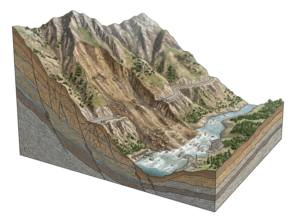
Landslide siteFlash floodRoad-cutting siteHimalayan ecosystem✎ Geo-hydrological disasters in the Himalayas are driven by the interplay of geological instability, extreme rainfall, and anthropogenic pressures, necessitating integrated risk reduction strategies that combine scientific…
Subject Relevance — Where This Topic Fits
- GS Paper III — Disaster Management | GS Paper III — Environment and Climate Change | GS Paper III — Indian Geography
- Prelims: Flash floods, Landslides, National Disaster Response Force (NDRF), Geological Survey of India (GSI), Himalayan ecosystem fragility, Cloudburst, National Disaster Management Authority (NDMA), Arunachal Pradesh topography
- Essay: Environmental degradation and human vulnerability: Lessons from Himalayan disasters, Climate change and the increasing frequency of extreme weather events in India
Quick Revision: Geo-hydrological disasters in the Himalayas are driven by the interplay of geological instability, extreme rainfall, and anthropogenic pressures, necessitating integrated risk reduction strategies that combine scientific assessment, regulatory enforcement, and community preparedness.
Why is this in the news?
On 15 August 2026, a devastating geo-hydrological event comprising a landslide in Arunachal Pradesh’s Upper Subansiri district and a subsequent flash flood in Dibang Valley district resulted in four civilian fatalities and left five Indian Army personnel missing. The incident, triggered by intense rainfall at a road-cutting site near Keojaring-Byaching, underscores the persistent challenge of managing natural hazards in the fragile Himalayan ecosystem, particularly in the context of climate-induced extreme weather events and unregulated anthropogenic interventions.
Background
- The Himalayan region, extending over 2,400 km across India, Nepal, Bhutan, and Pakistan, is one of the most geologically active and ecologically fragile zones globally, characterised by steep slopes, high seismic activity, and intense monsoon precipitation.
- Arunachal Pradesh, with 80% of its land under forest cover and over 60,000 sq km under mountainous terrain, is particularly susceptible to landslides and flash floods due to its young geological formations, high rainfall intensity, and anthropogenic pressures such as road construction, deforestation, and unplanned urbanisation.
- The state experiences an average annual rainfall of 2,000–4,000 mm, with extreme events like cloudbursts causing sudden surges in river discharge, transforming slopes into debris flows.
- India’s disaster management framework, anchored in the Disaster Management Act, 2005, mandates multi-tiered preparedness, response, and recovery mechanisms, including the National Disaster Response Force (NDRF), State Disaster Response Forces (SDRF), and district-level disaster management plans.
- Despite these institutional arrangements, recurring disasters in the Himalayas highlight gaps in pre-disaster risk reduction, enforcement of environmental regulations, and integration of scientific assessments into developmental planning.
- The incident occurs against the backdrop of increasing evidence linking climate change to the intensification of monsoon patterns, glacier retreat, and frequency of extreme weather events in the Hindu Kush Himalaya (HKH) region.
Geo-hydrological Disasters in the Himalayas: Mechanisms, Impacts and Governance
- Geo-hydrological disasters encompass a spectrum of events including landslides, debris flows, and flash floods, primarily triggered by the interaction of geological instability, hydrological extremes, and human activities.
- Landslides in the Himalayas are predominantly shallow, rapid-moving failures of soil and rock on steep slopes, often initiated by heavy rainfall that reduces shear strength and increases pore water pressure, leading to slope instability.
- Flash floods are sudden, high-velocity flows of water and debris that occur when intense rainfall overwhelms drainage systems, particularly in narrow, steep valleys typical of the Himalayan terrain; they are often preceded by landslides that mobilise sediment into river channels.
- Anthropogenic factors such as unregulated road construction, quarrying, deforestation, and poorly designed drainage systems exacerbate slope instability and sediment yield, transforming natural hazards into disasters.
- The Himalayan ecosystem’s fragility is further heightened by tectonic activity; the region lies in seismic zones IV and V, where even moderate earthquakes can trigger large-scale landslides and dam river systems, leading to outburst floods.
- Climate change projections for the HKH region indicate a rise in extreme precipitation events, glacier melt, and permafrost thaw, all of which are expected to increase the frequency and intensity of geo-hydrological disasters.
- India’s disaster management architecture, as per the Disaster Management Act, 2005, establishes a three-tier system: national (NDMA), state (SDMA), and district (DDMA), with the NDRF and SDRF as specialised response forces; however, implementation gaps persist in risk assessment and preparedness.
- Early warning systems, including rainfall thresholds, real-time monitoring of river discharge, and community-based alert mechanisms, are critical for reducing loss of life, but their deployment remains uneven across Himalayan states.
Key Features
| Feature | Significance |
|---|---|
| Flash flood and landslide in Arunachal Pradesh | Triggered by heavy rainfall, leading to loss of life and missing personnel in Upper Subansiri district. |
| Impact on local communities | Disruption of road connectivity at Keojaring-Byaching site, affecting livelihoods and access to essential services. |
| Search and rescue operations | NDRF and Army personnel engaged in coordinated efforts to locate missing individuals and recover the deceased. |
| Geological vulnerability of the region | Arunachal Pradesh’s mountainous terrain and monsoon-dependent weather patterns increase susceptibility to landslides and flash floods. |
| Human resource loss | Five Army personnel missing, highlighting risks faced by security forces in disaster-prone areas during operational duties. |
Why it Matters
Disaster Management
- Exposes gaps in real-time disaster prediction and early warning systems in remote Himalayan regions.
- Highlights the need for integrated response mechanisms between civil authorities, NDRF, and the Indian Army.
- Underscores the importance of community awareness and preparedness in high-risk zones.
Strategic Infrastructure
- Road cutting sites in Arunachal Pradesh are critical for connectivity to forward areas along the India-China border.
- Disruptions in such areas can impede military logistics and civilian mobility in strategically sensitive regions.
Environmental Governance
- Raises questions about unregulated construction and deforestation in ecologically fragile zones.
- Emphasises the role of the National Disaster Management Authority (NDMA) in enforcing sustainable land-use policies.
Humanitarian Crisis
- Loss of civilian lives and military personnel underscores the socio-economic toll of climate-induced disasters.
- Requires post-disaster rehabilitation measures for affected communities and families of the missing.
Challenges
1. Limited Early Warning Systems
- Inadequate real-time monitoring of rainfall and geological instability in remote Himalayan districts.
- Dependence on manual alerts rather than automated sensor-based systems.
UPSC Link: GS3: Disaster Management
2. Infrastructure Vulnerability
- Unplanned road construction in landslide-prone areas exacerbates geological instability.
- Lack of adherence to geotechnical safety standards in developmental projects.
UPSC Link: GS3: Infrastructure
3. Coordination Gaps in Rescue Operations
- Delayed integration of civilian and military resources due to bureaucratic and operational silos.
- Absence of a unified command structure for multi-agency disaster response.
UPSC Link: GS3: Disaster Management
4. Climate Change Intensification
- Increased frequency of extreme weather events in the Himalayas due to global warming.
- Need for climate-resilient infrastructure and disaster risk reduction strategies.
UPSC Link: GS3: Environment
5. Community Displacement and Rehabilitation
- Lack of long-term plans for resettlement of affected populations in disaster-prone regions.
- Inadequate compensation mechanisms for loss of livelihoods and property.
UPSC Link: GS2: Welfare Schemes
Challenges — UPSC Perspective
| Issue | Concern |
|---|---|
| Geological instability | Unregulated construction and deforestation in landslide-prone zones. |
| Early warning systems | Absence of automated, real-time monitoring in remote areas. |
| Inter-agency coordination | Silos between civil authorities, NDRF, and the Army delay rescue efforts. |
| Climate adaptation | Inadequate infrastructure to withstand increasing extreme weather events. |
| Post-disaster support | Lack of structured rehabilitation and compensation for affected communities. |
| Military operational risks | Security personnel face heightened risks during disaster response in hostile terrain. |
Way Forward
- Enhance real-time monitoring with automated weather stations and geological sensors in Himalayan districts.
- Mandate geotechnical audits for all road construction projects in ecologically fragile zones.
- Establish a unified disaster response command integrating NDRF, Army, and state agencies.
- Develop climate-resilient infrastructure standards for critical road networks in border regions.
- Strengthen community-based early warning systems through local disaster management committees.
- Formulate a national policy for post-disaster rehabilitation with clear compensation frameworks.
- Promote afforestation and sustainable land-use practices in high-risk areas.
- Conduct regular joint drills between civil authorities and security forces for disaster scenarios.
UPSC Value Addition
Keywords for Mains Answer-Writing
Disaster Management in India · National Disaster Response Force (NDRF) · Armed Forces in Disaster Relief · Flash Floods and Landslides in Himalayan States · Geological Survey of India (GSI) · National Disaster Management Authority (NDMA) · State Disaster Management Authorities (SDMAs) · Climate Change and Extreme Weather Events · Search and Rescue Operations · Constitutional Provisions on Disaster Management (Article 21, 355, 356) · National Policy on Disaster Management 2009 · Community-Based Disaster Preparedness
Concept Flow
Heavy rainfall → Saturation of soil → Landslide trigger → Flash flood in Keojaring-Byaching road cutting site → Road cutting disrupts natural drainage → Accelerates erosion and geological instability → Loss of civilian lives and Army personnel → Immediate search and rescue operations → NDRF and Army coordination → Challenges due to operational and bureaucratic silos → Post-disaster assessment → Identification of systemic gaps in early warning and infrastructure governance → Policy response → Need for climate-resilient development and inter-agency coordination frameworks
Prelims Practice Questions
Q1. Consider the following statements regarding the National Disaster Response Force (NDRF):
1. NDRF is a specialized force under the National Disaster Management Authority (NDMA).
2. NDRF personnel are drawn from the Central Armed Police Forces (CAPFs).
3. NDRF is mandated to conduct search and rescue operations only during natural disasters.
4. NDRF has been deployed in international missions for disaster relief.
How many of the above statements are correct?
- Only one
- Only two
- Only three
- All four
Answer: All four — Statements 1, 2, and 4 are correct. NDRF is indeed a specialized force under NDMA, its personnel are drawn from CAPFs, and it has participated in international disaster relief missions. Statement 3 is incorrect as NDRF also conducts operations during man-made disasters.
Q2. Assertion (A): The National Disaster Management Authority (NDMA) is chaired by the Prime Minister of India.
Reason (R): The NDMA is established under the Disaster Management Act, 2005, which vests the Chairmanship with the Prime Minister to ensure high-level political oversight and coordination.
Options:
A. Both A and R are true, and R is the correct explanation of A.
B. Both A and R are true, but R is not the correct explanation of A.
C. A is true, but R is false.
D. A is false, but R is true.
Answer: ? — Both Assertion (A) and Reason (R) are true. The NDMA is indeed chaired by the Prime Minister, and the Disaster Management Act, 2005, mandates this to ensure high-level coordination. R correctly explains A.
Q3. Match the following institutions with their primary roles in disaster management:
Column I (Institution) | Column II (Primary Role)
1. National Disaster Management Authority (NDMA) | A. Conducts search and rescue operations during disasters
2. National Disaster Response Force (NDRF) | B. Provides technical support for disaster risk reduction
3. Geological Survey of India (GSI) | C. Formulates policies and plans for disaster management
4. State Disaster Management Authority (SDMA) | D. Implements disaster management plans at the state level
Options:
A. 1-C, 2-A, 3-B, 4-D
B. 1-B, 2-A, 3-C, 4-D
C. 1-D, 2-C, 3-A, 4-B
D. 1-A, 2-D, 3-B, 4-C
- A
- B
- C
- D
Answer: A — The correct match is: 1-C (NDMA formulates policies), 2-A (NDRF conducts search and rescue), 3-B (GSI provides technical support), and 4-D (SDMA implements plans at the state level).
Mains Practice Question
✍ The increasing frequency of flash floods and landslides in Himalayan states like Arunachal Pradesh is a direct consequence of climate change and unregulated anthropogenic activities. Critically examine the efficacy of India’s institutional framework for disaster management in addressing such challenges. Also, outline the constitutional and statutory provisions that underpin disaster management in India. (15 Marks)
Approach: MODEL-ANSWER SKELETON:
1. **Introduction (2 marks)**: Define flash floods and landslides, their causes (climate change, deforestation, unplanned construction), and their impact on Himalayan states like Arunachal Pradesh. Mention the recent incident (August 2026) as a case study.
2. **Institutional Framework for Disaster Management (5 marks)**:
– **Constitutional Provisions**: Article 21 (Right to Life), Article 355 (Duty of the Union to protect states against external aggression and internal disturbance), Article 356 (President’s Rule in case of failure of constitutional machinery).
– **Statutory Framework**: Disaster Management Act, 2005 (NDMA, SDMAs, NDRF, National Institute of Disaster Management).
– **Key Institutions**:
– National Disaster Management Authority (NDMA): Role of Prime Minister as Chairperson, policy formulation.
– National Disaster Response Force (NDRF): Specialized force for search and rescue.
– State Disaster Management Authorities (SDMAs): Implementation at state level.
– Geological Survey of India (GSI): Technical support for risk assessment.
– **Community-Based Mechanisms**: Role of local communities, NGOs, and Panchayati Raj Institutions in preparedness and response.
3. **Efficacy and Challenges (5 marks)**:
– **Strengths**: NDMA’s policy framework, NDRF’s rapid response, integration of technology (early warning systems, GIS mapping).
– **Weaknesses**:
– Inadequate funding and resource allocation.
– Poor inter-agency coordination (e.g., between NDMA, SDMAs, and local authorities).
– Lack of awareness and preparedness at the grassroots level.
– Climate change exacerbating the frequency and intensity of disasters beyond institutional capacity.
– Regulatory gaps in construction and environmental compliance.
– **Recent Initiatives**: National Policy on Disaster Management 2009, National Disaster Management Plan 2016, and efforts to integrate climate change adaptation.
4. **Way Forward (3 marks)**:
– Strengthening early warning systems and real-time monitoring.
– Enhancing community-based disaster preparedness through training and awareness campaigns.
– Improving inter-agency coordination and resource allocation.
– Promoting sustainable development practices (e.g., afforestation, regulated tourism, and construction norms).
– Leveraging technology (AI, remote sensing) for risk assessment and response.
**Balance of Views**: Acknowledge the progress made in institutional frameworks while critiquing the gaps in implementation and the need for adaptive governance in the face of climate change.
Source: The Indian Express
Generated by AanyaAi for educational purpose.

- Gurugram’s groundwater extraction exceeds limit by 212%; HC seeks ban - October 4, 2026
- स्वतंत्रता सेनानी श्यामजी कृष्ण वर्मा की जन्म जयंती पर पीएम का श्रद्धांजलि - October 4, 2026
- KWML’s Feasibility Reports for Water Metro in 18 Cities: UPSC & PCS Insights - October 3, 2026

No Comments