
03 Apr India’s Multi-Hazard Early Warning System: A Leap Towards Disaster Resilience
This article covers “Daily Current Affairs” and From India’s Multi-Hazard Early Warning System: A Leap Towards Disaster Resilience
SYLLABUS MAPPING
GS -3- Science & Technology- India’s Multi-Hazard Early Warning System: A Leap Towards Disaster Resilience
FOR PRELIMS
What is impact-based forecasting?
FOR MAINS
What are the main features of modern weather forecasting systems?
Why in the News?
India is among the most disaster-prone countries in the world due to its vast geographical diversity, long coastline, and monsoon-dependent climate. Extreme weather events such as cyclones, floods, heatwaves, droughts, and landslides occur frequently, affecting millions of people and causing significant economic losses. According to various estimates, over 75% of India’s districts are exposed to multiple climate hazards, while floods alone impact nearly 40 million hectares annually. In this context, the development of the Multi-Hazard Early Warning Decision Support System (MHEW-DSS) by the India Meteorological Department represents a transformative shift from fragmented forecasting to an integrated, technology-driven disaster risk reduction framework.
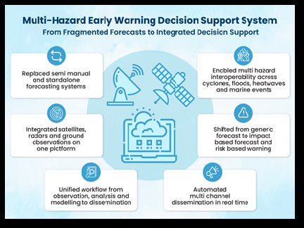
What is MHEW-DSS?
The MHEW-DSS is an advanced, webGIS-based digital forecasting platform launched in January 2024 under the broader framework of Mission Mausam. It integrates real-time meteorological data, advanced modelling tools, and geospatial technologies to deliver impact-based, location-specific early warnings. The system is designed to convert complex weather data into actionable insights for governments, disaster management agencies, and citizens. Unlike traditional forecasting systems, MHEW-DSS focuses not only on predicting weather events but also on assessing their potential impacts across sectors, thereby enabling timely and effective response measures.
Key System Characteristics
1. Interoperability: Seamless data sharing across sectors and institutions
2. Scalability: Ability to expand with new technologies and hazards
3. Replicability: Can be adopted by other countries and sectors
4. Efficiency: Faster and more accurate forecasts
5. Transparency: Open and verifiable processes
6. Responsiveness: Multi-channel dissemination of information
Core Objectives
The primary objective of MHEW-DSS is to develop an indigenous, integrated, and real-time forecasting system capable of handling multiple hazards simultaneously. It aims to:
1. Enhance the accuracy, lead time, and reliability of weather forecasts
2. Enable impact-based and risk-based warnings
3. Strengthen decision-making capabilities of authorities
4. Ensure last-mile connectivity of early warnings
5. Promote self-reliance in meteorological technologies
Salient Features of MHEW-DSS
1. Automated Data Processing: Over 90% of weather data collection, quality control, and integration is automated, reducing human intervention and improving efficiency.
2. Improved Forecast Accuracy: Use of over 95% of numerical weather prediction model inputs has improved forecast accuracy by nearly 30%.
3. Faster Forecast Preparation: Forecast preparation time has been reduced by about 50%, enabling quicker dissemination.
4. Extended Forecast Lead Time: Forecast window increased from 5 days to 7 days, improving preparedness.
5. Cost Efficiency: The system has generated savings of approximately ₹250 crore and reduced reliance on foreign technologies.
6. Impact-Based Warnings: Provides sector-specific advisories for agriculture, fisheries, transport, energy, and health sectors.
7. GIS-Based Visualization: Real-time maps and graphical tools enhance clarity and usability of forecasts.
Operational Architecture
1. It collects real-time data from multiple sources such as satellites, radars, automatic weather stations, and ocean buoys.
2. Data is standardized and processed on a unified platform for efficient analysis.
3. Advanced techniques like multi-model ensemble forecasting, bias correction, and consensus modelling improve reliability.
4. The core component, Weather Analysis and Forecast Enabling System (WAFES), enables meteorologists to analyse, visualize, and generate forecasts using GIS tools.
5. Dissemination occurs through multiple channels including SMS, mobile apps, APIs, emails, and the Common Alerting Protocol (CAP).
Institutional Framework
1. The Ministry of Earth Sciences acts as the nodal authority overseeing weather and climate services.
2. The India Meteorological Department serves as the primary operational agency responsible for forecasting and dissemination.
3. Mission Mausam (approved in 2024) provides technological and infrastructural support for improving forecasting capabilities.
4. Platforms like Mausamgram enable hyper-local forecasting covering over 1.5 lakh pin codes and more than 6 lakh villages.
Impact and Significance of MHEW-DSS
| Sector | Key Impact | Details / Outcomes |
|---|---|---|
| Disaster Risk Reduction | Improved forecasting & early evacuation | Enhanced cyclone prediction accuracy; enabled timely evacuation; zero casualties in some events; evacuation costs reduced to one-third (1999–2024) |
| Agriculture & Livelihoods | Higher farm productivity & income | Agromet advisories guide sowing, irrigation, harvesting; farmers reported ~52.5% higher income; strengthens rural resilience |
| Energy Sector | Efficient energy planning | Forecasts of solar radiation, wind, rainfall support renewable energy; protects infrastructure; improves grid management |
| Health & Environment | Reduced health risks & environmental benefits | Heatwave alerts reduce mortality; supports disease prediction (dengue, malaria); digital workflow reduces paper use & carbon emissions |
| Governance & Administration | Better coordination & efficiency | Fully digital system improves inter-agency coordination; used by 200+ organisations; reduces manual work; ensures cost & manpower savings |
Way Forward
1. AI & ML Integration: Leverage Artificial Intelligence and Machine Learning to enhance forecast accuracy, predictive modelling, and real-time data analysis.
2. Last-Mile Connectivity: Strengthen local dissemination systems using regional languages and offline alert mechanisms for remote areas.
3. Community Participation: Promote disaster awareness, capacity building, and community-based early warning systems.
4. Policy Integration: Link weather forecasts with urban planning, infrastructure design, and climate adaptation strategies for long-term resilience.
5. Institutional Coordination: Enhance coordination among central, state, and local agencies for seamless data sharing and faster decision-making.
6. Continuous Capacity Building: Invest in training of meteorologists, disaster managers, and local stakeholders to effectively interpret and use forecasts.
Q.Consider the following statements regarding MHEW-DSS:
1. It is developed using only foreign technology.
2. It provides impact-based and location-specific warnings.
3. It integrates data from satellites, radars, and weather stations.
Which of the statements given above is/are correct?
(a) 2 and 3 only
(b) 1 and 2 only
(c) 3 only
(d) 1, 2 and 3
Answer: A
Q. Discuss the institutional and technological framework of India’s early warning systems. Highlight challenges and suggest improvements.
(250 words)
- E-NAM and the Transformation of Agricultural Marketing in India - April 17, 2026
- Indian Railways: Journey from Steam Engines to a Modern Transport Backbone - April 16, 2026
- Mission Poshan 2.0: Strengthening India’s Nutrition Ecosystem - April 15, 2026

No Comments