


11 Aug PM GatiShakti NMP: UPSC Exam’s Game-Changer for Integrated Infrastructure Planning
✎ The PM GatiShakti National Master Plan is a transformative, data-driven framework for integrated infrastructure development, leveraging geospatial analytics to enhance multi-modal connectivity, reduce logistics costs, and improve…
Subject Relevance — Where This Topic Fits
- GS Paper II — Governance, Constitution, Polity, Social Justice and International Relations (Governance: e-governance, infrastructure governance) | GS Paper III — Economy (Infrastructure: Transport, Logistics, Connectivity; Economic Development: Logistics Efficiency, GDP Growth)
- Prelims: PM GatiShakti NMP, Network Planning Group (NPG), Logistics Cost as % of GDP, Multi-modal connectivity, National Logistics Policy, Sagarmala, Dedicated Freight Corridors, Expressways, National Highways, Geospatial Data, API Integration, Turn-around time, Ease of Doing Business
- Essay: Infrastructure as the backbone of economic development, Technology-driven governance for national transformation
Quick Revision: The PM GatiShakti National Master Plan is a transformative, data-driven framework for integrated infrastructure development, leveraging geospatial analytics to enhance multi-modal connectivity, reduce logistics costs, and improve economic efficiency without requiring a separate budgetary allocation.
Why is this in the news?
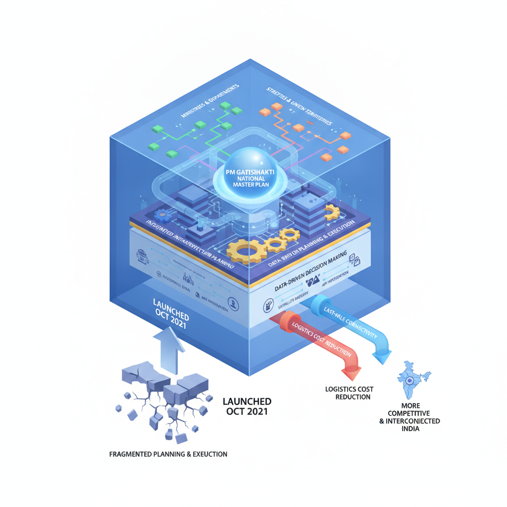
The Press Information Bureau (PIB), Ministry of Commerce and Industry, highlighted the operationalisation and integration of the PM GatiShakti National Master Plan (NMP) as a transformative ‘whole-of-government’ approach for synchronised infrastructure planning and execution across ministries, departments, states, and Union Territories. The initiative leverages geospatial data, satellite imagery, and API integration to enhance data-driven decision-making, improve last-mile connectivity, and reduce logistics costs, thereby fostering a more competitive and interconnected India.
Background
- Launched in October 2021, the PM GatiShakti National Master Plan (NMP) was conceptualised to address fragmented infrastructure planning and execution across multiple agencies, leading to delays, cost overruns, and suboptimal connectivity.
- The plan integrates 16 ministries and departments, including Road Transport and Highways, Railways, Ports, Shipping and Waterways, Civil Aviation, Petroleum and Natural Gas, Power, Telecommunications, and Urban Development.
- The framework is aligned with the National Logistics Policy (2022), Sagarmala, Bharatmala, and Dedicated Freight Corridors to create a seamless multi-modal transport network.
- The PM GatiShakti framework operates without a separate budgetary allocation, relying instead on the existing financial provisions of respective ministries and states for implementation.
What is the PM GatiShakti National Master Plan (NMP)?
- A holistic, integrated infrastructure planning framework designed to synchronise and coordinate the planning and execution of infrastructure projects across multiple sectors and jurisdictions.
- It employs geospatial data, satellite imagery, and API integration to create a unified digital dashboard for real-time monitoring, planning, and assessment of infrastructure development.
- The framework ensures ‘whole-of-government’ coordination by bringing together central ministries, state governments, Union Territories, and other stakeholders to eliminate silos and promote multi-modal connectivity.
- The PM GatiShakti NMP aims to enhance last-mile connectivity, reduce travel time, and improve the efficiency of goods, services, and people movement through seamless integration of transport modes (road, rail, air, waterways).
- The initiative facilitates data-driven decision-making by providing ministries and states with actionable insights derived from geospatial analytics, thereby improving project prioritisation and resource allocation.
- The Network Planning Group (NPG), a key body under the PM GatiShakti framework, evaluates major infrastructure projects for integrated planning, multi-modality, inter-modality, and last-mile connectivity, ensuring alignment with national priorities.
- As of August 2026, 396 infrastructure projects with an estimated total cost of ₹18.66 lakh crore have been evaluated by the NPG, of which 256 projects have been approved and 198 are under implementation.
Key Features
| Feature | Significance |
|---|---|
| Holistic ‘Whole-of-Government’ Approach | Integrates planning and execution across 58 central ministries, 36 states/UTs, and all infrastructure sectors using a unified digital framework. |
| Geospatial Data Integration | Uses satellite imagery, APIs, and real-time analytics to enable evidence-based decision-making for infrastructure planning and monitoring. |
| Network Planning Group (NPG) | Evaluates 396 multi-modal projects (₹18.66 lakh crore) for inter-ministerial synergy, last-mile connectivity, and data-driven prioritisation. |
| PM GatiShakti Public Platform (launched Sep 2025) | Provides open access to analytics for private entities, researchers, and citizens to foster transparency and stakeholder collaboration. |
| Multi-Modal Connectivity Focus | Aims to reduce logistics costs, travel time, and improve business ease by synchronising road, rail, ports, aviation, and utility corridors. |
Why it Matters
Economic Competitiveness
- Reduces logistics cost to 7.9% of GDP (2025 NCAER assessment), aligning with advanced economies and enhancing export competitiveness.
- National Highway investments yield ₹3.2 GDP growth per ₹1 spent (IIM Bangalore study), demonstrating high fiscal multipliers.
- Supports ‘Make in India’ by improving supply-chain efficiency and reducing turnaround time for industries.
Strategic Infrastructure Development
- Enables last-mile connectivity through coordinated planning of expressways, dedicated freight corridors, and industrial corridors.
- Accelerates port-led development (Sagarmala) and inland waterways, reducing dependence on congested road networks.
- Facilitates seamless movement of goods/services via integrated rail, road, and air networks, critical for hinterland integration.
Governance and Policy Integration
- Replaces siloed departmental planning with a unified framework, reducing duplication and inter-ministerial delays.
- Leverages digital public infrastructure (geospatial data, APIs) to enhance transparency and accountability in project approvals.
- Aligns with National Logistics Policy (2022) and PM GatiShakti’s objective of a ‘connected India’ by 2030.
Social and Regional Equity
- Prioritises rural and hinterland connectivity to bridge urban-rural divides, supporting inclusive growth.
- Integrates social infrastructure (schools, hospitals) with economic corridors to ensure balanced regional development.
- Reduces travel time and logistics costs for MSMEs and farmers, enhancing livelihood opportunities.
Challenges
1. Data Quality and Interoperability
- Fragmented data sources across ministries may lead to inconsistencies in geospatial and project-level analytics.
- Need for standardised APIs and metadata protocols to ensure seamless integration across platforms.
UPSC Link: GS-III: Infrastructure
2. Implementation Bottlenecks
- Delays in land acquisition, environmental clearances, and inter-state coordination can stall multi-modal projects.
- Resource constraints in states/UTs may limit capacity for concurrent project execution.
UPSC Link: GS-II: Centre-State Relations
3. Private Sector Participation
- Limited incentives for private entities to utilise PM GatiShakti analytics for project planning and investment decisions.
- Need for PPP models to de-risk infrastructure financing and accelerate corridor development.
UPSC Link: GS-III: Investment Models
4. Monitoring and Evaluation
- Lack of a unified performance dashboard to track real-time progress of 396 projects across ministries.
- Need for third-party audits to assess cost overruns, delays, and socio-economic impact.
UPSC Link: GS-III: Infrastructure Financing
Challenges — UPSC Perspective
| Issue | Concern |
|---|---|
| Geospatial Data Gaps | Incomplete or outdated satellite imagery in remote/forested regions affects project feasibility studies. |
| Multi-Stakeholder Coordination | Divergent priorities among ministries/states lead to delays in approvals and clearances. |
| Digital Divide | Uneven access to PM GatiShakti Public Platform in rural areas limits stakeholder engagement. |
| Environmental Safeguards | Balancing rapid infrastructure growth with forest rights, biodiversity, and climate resilience. |
| Skill Shortages | Deficit of trained personnel in states/UTs for geospatial analysis and project management. |
Government Initiatives — Must-Memorise for Prelims
- PM GatiShakti National Master Plan (PMGS-NMP)
- National Logistics Policy (NLP)
- Sagarmala Programme
- Bharatmala Pariyojana
- Dedicated Freight Corridors (DFCs)
Way Forward
- Strengthen inter-ministerial data-sharing protocols to ensure real-time geospatial updates and reduce silos.
- Establish a dedicated ‘PM GatiShakti Cell’ in each state/UT to streamline clearances and monitor project milestones.
- Expand PPP frameworks for multi-modal corridors, with viability gap funding for high-impact projects.
- Develop a national logistics cost index to benchmark progress and identify bottlenecks annually.
- Integrate PM GatiShakti analytics with state-level GIS platforms for granular planning at district level.
- Conduct capacity-building programs in state PWD/IR departments for geospatial technology adoption.
- Introduce performance-linked incentives for ministries/states to meet project timelines and cost targets.
- Leverage AI/ML for predictive analytics to forecast demand-supply gaps in logistics and infrastructure.
UPSC Value Addition
Keywords for Mains Answer-Writing
PM Gati Shakti National Master Plan · holistic infrastructure planning · multi-modal connectivity · Network Planning Group · geospatial data integration · logistics cost reduction · National Logistics Policy · economic competitiveness · infrastructure governance · data-driven decision making
Constitutional & Policy Linkages
- Article 298: Power to carry on trade or business by the Union or a State.
- Article 299: Contracts by the Union or a State.
Concept Flow
Multi-modal infrastructure projects identified by ministries/states → Geospatial data integration via PMGS-NMP → NPG evaluates synergy and feasibility → Approvals under existing budgetary provisions → Concurrent execution with inter-ministerial coordination → Reduced logistics costs and travel time → Enhanced economic competitiveness and regional equity.
Prelims Practice Questions
Q1. Consider the following statements regarding the PM Gati Shakti National Master Plan (NMP):
1. It is a centrally sponsored scheme with a dedicated budgetary allocation.
2. The Network Planning Group (NPG) evaluates infrastructure projects under the PM Gati Shakti framework.
3. The PM Gati Shakti NMP integrates data from satellite imagery and APIs for infrastructure planning.
4. The initiative aims to reduce logistics costs to below 5% of GDP.
How many of the above statements are correct?
- Only one
- Only two
- Only three
- All four
Answer: Only three — Statements 2 and 3 are correct. Statement 1 is incorrect as PM Gati Shakti does not have a separate budgetary provision. Statement 4 is incorrect as the logistics cost is estimated at 7.9% of GDP, not below 5%.
Q2. Assertion (A): The PM Gati Shakti National Master Plan (NMP) is designed to integrate infrastructure planning across multiple sectors.
Reason (R): The initiative uses geospatial data and APIs to facilitate data-driven decision making in infrastructure development.
In the context of the above two statements, which one of the following is correct?
- Both A and R are true, and R is the correct explanation of A.
- Both A and R are true, but R is not the correct explanation of A.
- A is true, but R is false.
- A is false, but R is true.
Answer: Both A and R are true, and R is the correct explanation of A. — Both the Assertion (A) and Reason (R) are true. The PM Gati Shakti NMP indeed integrates infrastructure planning across sectors (A), and it employs geospatial data and APIs to enable data-driven decision making (R). R correctly explains A.
Mains Practice Question
✍ The PM Gati Shakti National Master Plan (NMP) represents a paradigm shift in infrastructure governance in India. Critically examine its role in enhancing multi-modal connectivity and reducing logistics costs. Also, analyse how the initiative aligns with the broader objectives of economic competitiveness and sustainable development. (15 Marks)
Approach: MODEL-ANSWER SKELETON:
1. **Introduction (2 Marks)**
– Define PM Gati Shakti NMP: A holistic, data-driven framework for integrated infrastructure planning.
– Context: Launched in October 2021 to address fragmented planning and execution across ministries/states.
– Objective: To ensure seamless connectivity (roads, railways, ports, airports, etc.) and reduce logistics costs.
2. **Multi-Modal Connectivity (4 Marks)**
– **Integrated Planning**: How the NMP brings together 58 central ministries, 36 states/UTs, and private stakeholders under a single framework.
– **Network Planning Group (NPG)**: Role in evaluating 396 projects (₹18.66 lakh crore) for inter-ministerial synergy (e.g., Dedicated Freight Corridors, Bharatmala, Sagarmala).
– **Geospatial Data & APIs**: Use of satellite imagery (e.g., ISRO data) and real-time analytics to identify gaps and optimize routes.
– **Case Example**: National Highway projects (e.g., Delhi-Mumbai Expressway) demonstrating 3.2x GDP multiplier effect per rupee spent.
3. **Logistics Cost Reduction (4 Marks)**
– **Current Status**: Logistics cost at 7.9% of GDP (2025 NCAER study), aligning with advanced economies.
– **Mechanisms**:
– Single-window clearance via PM Gati Shakti Public Platform (launched September 2025).
– Alignment with National Logistics Policy (2022) to improve turnaround time and ease of doing business.
– Reduction in transit delays (e.g., port dwell time from 4-5 days to 2 days in select cases).
– **Economic Impact**: Improved manufacturing competitiveness and export performance (cited in Economic Survey 2023-24).
4. **Alignment with Economic Competitiveness & Sustainable Development (3 Marks)**
– **Competitiveness**: Enhanced infrastructure reduces transaction costs, attracting FDI and boosting industrial corridors (e.g., Delhi-Mumbai Industrial Corridor).
– **Sustainability**: Focus on green logistics (e.g., Gati Shakti for electric vehicle charging stations, coastal shipping to reduce carbon footprint).
– **Challenges**: Coordination gaps, state-level implementation delays, and data privacy concerns in geospatial integration.
5. **Critical Analysis & Way Forward (2 Marks)**
– **Strengths**: Overcomes siloed governance, leverages technology, and aligns with global best practices (e.g., EU’s Trans-European Transport Network).
– **Limitations**: Lack of statutory backing for NPG decisions; need for stronger federal cooperation.
– **Suggestions**: Institutionalize NPG recommendations, expand public-private partnerships, and integrate climate resilience into planning.
**Balanced Conclusion**: PM Gati Shakti NMP is a transformative initiative but requires sustained political will, technological upgrades, and inter-state collaboration to realize its full potential.
Source: PIB (Press Information Bureau)
Generated by AanyaAi for educational purpose.

- Gurugram’s groundwater extraction exceeds limit by 212%; HC seeks ban - October 4, 2026
- स्वतंत्रता सेनानी श्यामजी कृष्ण वर्मा की जन्म जयंती पर पीएम का श्रद्धांजलि - October 4, 2026
- KWML’s Feasibility Reports for Water Metro in 18 Cities: UPSC & PCS Insights - October 3, 2026

No Comments