
18 Jan Svamitva Scheme: A Landmark Initiative for Rural Development
SYLLABUS MAPPING:
GS-2- Social issues- Svamitva Scheme: A Landmark Initiative for Rural Development
FOR PRELIMS:
What is the role of drone and GIS technology in the implementation of the SVAMITVA Scheme?
FOR MAINS
Explain the objectives and significance of the SVAMITVA Scheme in rural development in India.
Why in the news?
Prime Minister Narendra Modi’s distribution of over 65 lakh property cards under the SVAMITVA Scheme is making headlines as a major step towards rural empowerment in India. This milestone, set through a video conference, marks the issuance of property cards to residents in over 50,000 villages across 10 states and two Union Territories.m The SVAMITVA (Survey of Villages and Mapping with Improvised Technology in Village Areas) Scheme, launched in April 2020, aims to provide legal ownership documents to rural property owners. The initiative uses advanced drone and GIS technology to map land and grant a ‘Record of Rights’ to property owners. With nearly 2.25 crore property cards set to be issued, including 65 lakh in this single distribution, the scheme is significantly formalizing land ownership in rural India.
What is the SVAMITVA Scheme
The SVAMITVA Scheme (Survey of Villages and Mapping with Improvised Technology in Village Areas) is a central government initiative designed to provide property rights to rural households in India. Launched by the Prime Minister of India on April 24, 2021, the scheme leverages advanced technologies, including drone surveying, to map land parcels in rural areas and create accurate property records. The SVAMITVA Scheme was introduced to address the longstanding challenge of incomplete survey and settlement of rural land, particularly in village Abadi (inhabited) areas. For decades, many rural properties lacked formal documentation, preventing property owners from accessing institutional credit or using their land as a financial asset. This gap in land records not only left rural landowners vulnerable but also hindered economic development, limiting their access to financial assistance, loans, and opportunities for growth.
Achievements of the Scheme:
1. Property Card Distribution: As of December 27, 2024, 57 lakh property cards have been distributed across 46,351 villages in 10 states (Chhattisgarh, Gujarat, Himachal Pradesh, Madhya Pradesh, Maharashtra, Mizoram, Odisha, Punjab, Rajasthan, Uttar Pradesh) and 2 Union Territories (Jammu & Kashmir and Ladakh).
2. Widespread Adoption: The scheme aims to provide a ‘Record of Rights’ for rural household owners, and it has been onboarded by 31 states and union territories (UTs).
3. Drone Surveys: Drone surveys have been completed in 3.17 lakh villages, including the UTs of Lakshadweep, Ladakh, Delhi, Dadra & Nagar Haveli, and Daman & Diu, as well as states like Madhya Pradesh, Uttar Pradesh, and Chhattisgarh.
4. Property Cards Generated: Over 2.19 crore property cards have been prepared for nearly 1.49 lakh villages. States like Haryana, Uttarakhand, Puducherry, Tripura, Andaman and Nicobar Islands, and Goa have already generated property cards for all their inhabited villages.
5. Centralized Monitoring: A centralized online dashboard tracks the real-time progress of the scheme’s implementation, making it easier for stakeholders to monitor its advancement.
6. Digital Access: Property cards are now available digitally via the DigiLocker app, enabling beneficiaries to view and download them seamlessly.
7. Advanced Survey Technology: The scheme employs survey-grade drones and the Continuous Operating Referencing System (CORS) network, producing high-resolution maps quickly and accurately, significantly improving rural land demarcation.
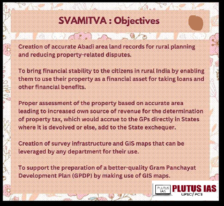
Key features of the SVAMITVA Scheme:
1. Property Records for Rural Households: It aims to provide clear and accurate property records to households in rural areas, formalizing their land ownership.
2. Drone Technology for Mapping: The scheme uses drone technology to map land parcels accurately, ensuring precision in land record creation.
3. Legal Ownership Cards (Property Cards): It issues legal property cards or title deeds to the owners, which serve as proof of ownership.
4. Reduction of Property Disputes: By providing legal clarity on ownership, the scheme helps in minimizing land-related disputes.
5. Monetization of Property: Rural households can use their land as a financial asset, enabling them to access credit and engage in economic activities.
6. Access to Bank Loans: With legal ownership documents, rural citizens can approach financial institutions for loans using their property as collateral.
7. Improved Rural Planning: Accurate land records aid in better rural planning and development by government bodies.
8. Collaboration Among Stakeholders: The scheme involves collaboration between various bodies, such as the Ministry of Panchayati Raj, state departments, and the Survey of India for effective implementation.
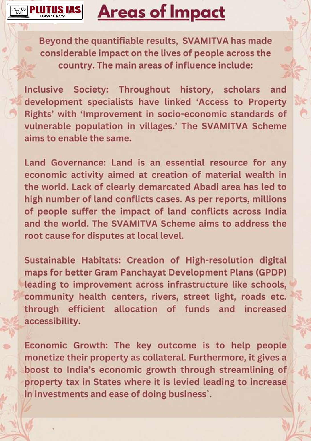
What is the significance of the SVAMITVA Scheme?
1. Formalizing Property Ownership: Aims to provide legal property titles to 1 crore+ rural households. Around 25 lakh property cards have been issued by 2024.
2. Access to Credit: Property cards enable rural families to access bank loans by using land as collateral, boosting financial inclusion.
3. Reducing Land Disputes: The scheme reduces disputes by creating accurate land records using drones and GIS, resolving 30-40% of land disputes in pilot regions.
4. Infrastructure & Planning: Provides detailed land maps for better rural governance and infrastructure development.
5. Gender Equality: Supports women’s land ownership rights, helping increase the 13% land ownership by women in rural India.
6. Economic Empowerment: Enables investment in agriculture and businesses, unlocking the economic value of rural land.
7. Revenue Generation: Accurate land records assist in better tax collection, improving government revenues.
What are the challenges associated with the SVAMITVA Scheme?
1. Difficult Terrain: Remote areas with poor infrastructure make drone mapping and data collection challenging.
2. Infrastructure Gaps: 60% of rural India lacks basic infrastructure like roads, electricity, and internet, slowing down implementation.
3. Community Resistance: Rural populations’ reluctance to participate in surveys due to lack of awareness or fear of losing land rights.
4. Ownership Disputes: Family disputes over land and unclear inheritance complicate accurate ownership identification, especially in states like Uttar Pradesh.
5. Data Accuracy: Ensuring accurate validation of land data, particularly in regions with outdated records.
6. Implementation Delays: Phased rollout across 6.62 lakh villages facing delays in certain regions, especially in states like Madhya Pradesh.
7. Capacity Building: Limited training on drones and GIS for local officials, especially in remote areas, hindering effective implementation.
8. Legal Challenges: Varying state-specific land laws and the need for legal coordination among agencies create discrepancies.
Way forward:
1. Infrastructure Development: Expediting the improvement of rural infrastructure, such as internet connectivity, roads, and electricity, will enhance the effectiveness of the drone surveys and ensure smoother implementation across all villages.
2. Awareness and Outreach: Expanding awareness campaigns to educate rural populations about the benefits of the scheme and addressing concerns regarding land rights will foster greater participation and reduce resistance.
3. Improved Training Programs: Providing more extensive training on drone technology and GIS for local officials will ensure higher-quality land surveys and more accurate property records.
4. Legal Reforms and Coordination: Streamlining legal frameworks and coordinating with state governments to resolve discrepancies in land laws will help to smoothen the integration of land records and property titles.
5. Addressing Disputes: Developing a clear, efficient process for resolving ownership disputes, especially those related to inheritance, will be essential in making the scheme truly beneficial for all.
6. Gender Sensitization: Ensuring that the scheme includes measures to address women’s land rights and increase women’s ownership of property is crucial for promoting gender equality in rural areas.
Conclusion:
The SVAMITVA Scheme stands as a landmark initiative in India’s rural development efforts. By providing legal recognition of land ownership and leveraging advanced technologies like drones and GIS, it is addressing long-standing issues related to rural land records. Though challenges remain, including infrastructure gaps, legal hurdles, and community resistance, the scheme has the potential to significantly improve the socio-economic conditions of rural India. By formalizing land ownership, reducing disputes, and unlocking financial opportunities, the scheme can pave the way for sustainable rural growth, economic empowerment, and improved governance.
Prelims Question:
Q. Which of the following technologies are used in the implementation of the SVAMITVA Scheme?
1. Drones
2. GIS Technology
3. Satellite Mapping
4. GPS Technology
Select the correct answer using the code given below:
A. 1 and 2 only
B. 1 and 3 only
C. 1, 2, and 4 only
D. 1, 2, and 3 only
Answer: A
Mains Question:
(250 words, 15 marks)
- E-NAM and the Transformation of Agricultural Marketing in India - April 17, 2026
- Indian Railways: Journey from Steam Engines to a Modern Transport Backbone - April 16, 2026
- Mission Poshan 2.0: Strengthening India’s Nutrition Ecosystem - April 15, 2026

No Comments