


21 Jul UPSC Focus: Drone-Based Land Surveys Boost Rural Property Rights & Revenue
Subject Relevance — Where This Topic Fits
- GS Paper II — Governance, Transparency and Accountability | GS Paper III — Land Reforms, Digital Infrastructure and Rural Development
- Prelims: SVAMITVA Scheme, Continuously Operating Reference Stations (CORS), Property Cards, Land Titling, Digital Land Records, Rural Land Disputes, Panchayati Raj Institutions, Geospatial Technology, Financial Inclusion through Property Rights
- Essay: Role of Technology in Rural Governance and Empowerment, Land Reforms as a Catalyst for Rural Economic Growth
Quick Revision: SVAMITVA scheme leverages drone-based surveys and CORS technology to create high-precision rural land records, issue property cards, reduce disputes, and enhance financial inclusion through transparent land titling.
Why is this in the news?
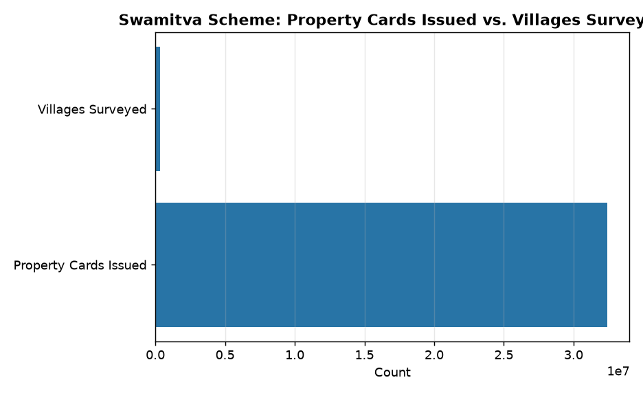
On 21 July 2026, the Ministry of Panchayati Raj, Government of India, informed the Lok Sabha that the SVAMITVA scheme has achieved significant milestones in drone-based land surveys and digitisation of property records across rural India. As of the date, surveys have been completed in 3.30 lakh villages, and 3.24 crore property cards have been issued in 1.97 lakh villages. The scheme utilises geospatial technologies such as Continuously Operating Reference Stations (CORS) to create high-precision maps, thereby reducing land disputes and enhancing transparency in rural land records. A study by IIM Ahmedabad has also highlighted the scheme’s positive impact on access to bank credit and increased revenue for Gram Panchayats through property taxation.
Background
- The SVAMITVA (Survey of Villages and Mapping with Improvised Technology in Village Areas) scheme was launched by the Government of India to provide ‘Record of Rights’ to property owners in rural inhabited areas, thereby reducing property disputes and enhancing financial inclusion.
- The scheme is implemented by the Ministry of Panchayati Raj in collaboration with the Survey of India, State Revenue Departments, and Panchayati Raj Institutions (PRIs).
- Geospatial technologies, including drone surveys and CORS, are employed to create high-accuracy maps of rural inhabited areas, ensuring precise demarcation of property boundaries.
- The scheme aims to integrate land records with digital platforms, enabling transparent and tamper-proof property records accessible to citizens and authorities.
- Rural land disputes are a significant challenge in India, often leading to prolonged legal battles and economic stagnation in rural areas.
- The scheme aligns with broader national objectives such as ‘Digital India’, ‘Atmanirbhar Bharat’, and ‘Sabka Saath, Sabka Vikas’ by leveraging technology for inclusive rural development.
What is the SVAMITVA Scheme?
- SVAMITVA is a Central Sector Scheme to provide legal ownership status to property owners in rural inhabited areas through the issuance of property cards.
- The scheme utilises drone-based surveys and Continuously Operating Reference Stations (CORS) to create high-precision maps of rural inhabited areas, ensuring accurate demarcation of property boundaries.
- Property cards issued under the scheme serve as legal documents, enabling property owners to access bank loans, avail government schemes, and resolve disputes more efficiently.
- The scheme mandates terrestrial verification and resolution of objections or disputes by competent state authorities before the issuance of property cards, ensuring transparency and fairness.
- As of 21 July 2026, surveys have been completed in 3.30 lakh villages, and 3.24 crore property cards have been issued in 1.97 lakh villages across India.
- The scheme has been evaluated by IIM Ahmedabad to assess its impact on access to bank credit and revenue generation for Gram Panchayats, with findings indicating a significant increase in both parameters.
- The scheme is implemented in a phased manner, with priority given to states and Union Territories based on their preparedness and administrative capacity.
- SVAMITVA aims to reduce rural land disputes, enhance financial inclusion, and empower Panchayati Raj Institutions through digitised land records.
Key Features
| Feature | Significance |
|---|---|
| Drone-based land survey | Enables high-precision geospatial mapping of rural inhabited areas using Continuous Operating Reference Station (CORS) technology, reducing human error in boundary demarcation. |
| Property card issuance | Formalises land ownership records in rural areas, providing legal recognition to property holders and facilitating access to financial services. |
| Land dispute resolution mechanism | Mandates terrestrial verification and grievance redressal prior to card issuance, enhancing transparency and fairness in property demarcation. |
| Impact assessment study (IIM Ahmedabad) | Evaluates the scheme’s economic outcomes, including increased bank loan disbursements and higher revenue generation for gram panchayats. |
| Digital property records | Creates a centralised, tamper-proof database of rural land records, enabling efficient governance and reducing litigation. |
Why it Matters
Economic Empowerment
- Facilitates collateral-based lending by banks, as property cards serve as verifiable assets, enhancing rural credit access.
- Increases revenue for gram panchayats through enhanced property tax collection and other local levies, strengthening rural fiscal autonomy.
- Reduces transaction costs in land markets by providing clear, dispute-free ownership records.
Governance & Transparency
- Establishes a single source of truth for land records, minimising fraud and malpractices in rural property transactions.
- Enables real-time monitoring of land use changes, supporting sustainable rural development planning.
- Enhances accountability in local governance by digitising records and reducing discretionary powers in land administration.
Legal & Institutional Framework
- Strengthens the implementation of the Land Records Modernisation Programme (LRMP) by integrating drone surveys with existing cadastral systems.
- Provides a scalable model for integrating geospatial technologies in rural land governance, aligning with the National Geospatial Policy 2022.
- Supports the Digital India Land Records Modernisation Programme (DILRMP) by ensuring end-to-end digitisation of rural land records.
Challenges
1. Technical & Infrastructure Constraints
- High initial capital expenditure for drone deployment, CORS network establishment, and training of survey personnel.
- Dependence on weather conditions for drone operations, which may delay survey completion in monsoon-prone regions.
- Limited interoperability between drone-based surveys and existing land records systems in some states, leading to data silos.
UPSC Link: GS-III: Science & Tech
2. Legal & Institutional Bottlenecks
- Lack of uniform land laws across states, complicating the integration of drone-based records with legal frameworks.
- Slow pace of grievance redressal due to inadequate staffing in local revenue departments.
- Resistance from traditional land record keepers (patwaris) and local elites, who may perceive digitisation as a threat to their influence.
UPSC Link: GS-II: Governance
3. Socio-Economic Barriers
- Low awareness among rural populations about the scheme’s benefits, leading to underutilisation of property cards.
- Digital divide in rural areas, where limited internet access and low digital literacy hinder effective implementation.
- Potential for elite capture, where influential landowners manipulate records to their advantage.
UPSC Link: GS-I: Social Issues
4. Data Security & Privacy Concerns
- Risk of data breaches or unauthorised access to sensitive land records, necessitating robust cybersecurity measures.
- Lack of a national framework for data sharing between states, which may lead to inconsistencies in records.
- Need for strict protocols to prevent misuse of property cards for fraudulent transactions.
UPSC Link: GS-III: Security
Challenges — UPSC Perspective
| Issue | Concern |
|---|---|
| Inter-state data inconsistency | Variations in land laws and record-keeping practices impede seamless integration of drone-based surveys. |
| Grievance redressal delays | Overburdened revenue departments struggle to resolve disputes in a timely manner. |
| Digital literacy gaps | Low awareness among rural populations limits the scheme’s outreach and effectiveness. |
| Cybersecurity vulnerabilities | Centralised digital records are susceptible to hacking or manipulation without adequate safeguards. |
| Elite capture risks | Local power structures may exploit the scheme to alter records in their favour. |
| Weather dependency | Monsoon seasons disrupt drone operations, delaying survey completion in critical regions. |
Way Forward
- Strengthen inter-state coordination to harmonise land laws and ensure seamless integration of drone-based records.
- Expand digital literacy programmes in rural areas to enhance public awareness and utilisation of property cards.
- Accelerate the establishment of CORS networks in underserved regions to improve survey accuracy and reduce delays.
- Develop a national framework for data sharing and cybersecurity to safeguard land records against breaches.
- Streamline grievance redressal mechanisms by increasing staffing in revenue departments and leveraging AI for dispute resolution.
- Conduct periodic impact assessments to identify bottlenecks and refine the scheme’s implementation strategy.
- Promote public-private partnerships to reduce the financial burden of drone deployment and training.
- Integrate drone-based surveys with other rural development schemes (e.g., PM-KISAN, MGNREGA) to maximise socio-economic benefits.
UPSC Value Addition
Keywords for Mains Answer-Writing
Digital India Land Records Modernisation Programme (DILRMP) · SVAMITVA Scheme · Drone-based land survey · Property rights in rural India · Continuously Operating Reference Station (CORS) · Land titling and dispute resolution · Revenue administration reforms · Financial inclusion through land records · Panchayati Raj institutions · Land revenue enhancement · E-governance in land records · Property card and bank credit linkage
Concept Flow
Drone-based land survey using CORS technology → High-precision geospatial mapping → Property card issuance → Legal recognition of ownership → Enhanced access to bank loans and revenue generation → Reduced land disputes → Strengthened rural governance and economic empowerment
Prelims Practice Questions
Q1. Which of the following is NOT a feature of the SVAMITVA Scheme?
- A. It uses CORS technology for high-precision mapping.
- B. It issues property cards to rural landowners.
- C. It mandates compulsory land redistribution among farmers.
- D. It resolves property disputes through local authorities.
Answer: C. It mandates compulsory land redistribution among farmers. — The SVAMITVA Scheme focuses on mapping, issuing property cards, and dispute resolution, but does not mandate land redistribution, which is a policy outside its scope.
Q2. What is the primary objective of the Digital India Land Records Modernisation Programme (DILRMP)?
- A. To digitise all urban land records within five years.
- B. To modernise land records and minimise property disputes in rural India.
- C. To provide financial incentives to urban property owners.
- D. To replace the existing land revenue system with a uniform tax regime.
Answer: B. To modernise land records and minimise property disputes in rural India. — DILRMP aims to modernise land records, enhance transparency, and reduce disputes, particularly in rural areas, through digitisation and technology adoption.
Mains Practice Question
✍ Examine the significance of the SVAMITVA Scheme in transforming rural land governance in India. How has the integration of drone-based surveys and digital property records contributed to financial inclusion and revenue enhancement at the grassroots level? Substantiate your answer with empirical evidence.
Approach: Begin by outlining the objectives and operational framework of the SVAMITVA Scheme, including the use of CORS technology and drone-based surveys. Analyse its impact on reducing property disputes and enhancing transparency in land records. Discuss the empirical findings from the IIM Ahmedabad study, highlighting the increase in bank credit availability and revenue generation for Panchayati Raj institutions. Conclude with the broader implications for rural economic development and governance reforms under Digital India.
Source: PIB (Press Information Bureau)
Generated by AanyaAi for educational purpose.

- UPSC Civil Services (Main) Examination 2026 — Sanskrit Literature Paper II: Question Paper | Plutus IAS - September 21, 2026
- चीनी राष्ट्रपति शी जिनपिंग अमेरिका दौरे पर, ट्रंप से मिलेंगे वार्ता हेतु - September 21, 2026
- Xi Jinping’s US Visit: Key Takeaways for UPSC & State PCS Aspirants - September 21, 2026

No Comments