


07 Aug IMD’s Panchayat-Level Weather Forecasts Boost Farming in Telangana
✎ The IMD’s panchayat-level weather forecasting in Telangana integrates Numerical Weather Prediction (NWP) models and AI-based systems to generate high-resolution rainfall forecasts, disseminated via the Panchayat Mausam Seva…
Subject Relevance — Where This Topic Fits
- GS Paper III — Science and Technology (Applications of AI and Numerical Weather Prediction in Disaster Management) | GS Paper III — Agriculture (Agro-meteorological Advisories and Climate-Resilient Farming)
- Prelims: Quantitative Precipitation Forecasts (QPF), National Seismological Network (NSN), Panchayat Mausam Seva Portal, Krishi Sakhis, Pashu Sakhis, Flood Meteorological Offices, Central Water Commission (CWC)
- Essay: Climate Change and Technological Innovation: Balancing Progress with Sustainability, Agriculture in India: From Traditional Practices to Climate-Smart Solutions
Quick Revision: The IMD’s panchayat-level weather forecasting in Telangana integrates Numerical Weather Prediction (NWP) models and AI-based systems to generate high-resolution rainfall forecasts, disseminated via the Panchayat Mausam Seva Portal and grassroots networks like Krishi Sakhis and Pashu Sakhis, to enhance agricultural resilience and flood preparedness.
Why is this in the news?
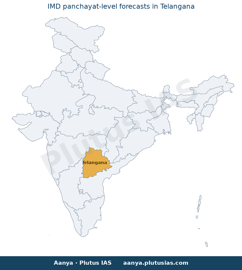
The Union Minister of State (Independent Charge) for Earth Sciences, Jitendra Singh, informed the Rajya Sabha on August 6, 2026, about the India Meteorological Department’s (IMD) initiative to provide panchayat-level weather forecasts to farmers in Telangana. This initiative integrates numerical weather prediction (NWP) models with artificial intelligence (AI) to generate high-resolution rainfall forecasts, which are critical for flood forecasting in the Godavari and Krishna river basins. The announcement underscores the Centre’s commitment to leveraging advanced technologies for disaster preparedness and agricultural advisory services, particularly in vulnerable regions.
Background
- The India Meteorological Department (IMD), under the Ministry of Earth Sciences, is the nodal agency responsible for meteorological observations, weather forecasting, and seismological monitoring in India.
- Flood forecasting in India is a collaborative effort between the Central Water Commission (CWC) and state governments, with the CWC issuing flood forecasts at identified locations based on hydrological and meteorological data.
- Telangana, a state prone to both floods and droughts, has been a focus area for integrating advanced weather forecasting systems to mitigate agricultural and hydrological risks.
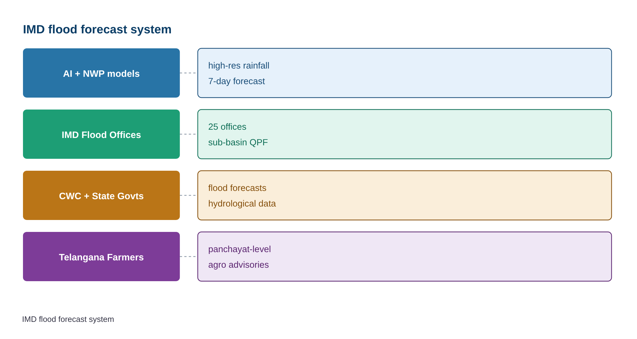
- The IMD operates 25 Flood Meteorological Offices across the country, issuing daily sub-basin-wise Quantitative Precipitation Forecasts (QPFs) valid for up to seven days, covering 220 sub-basins.
- Agro-meteorological advisories are essential tools for farmers to make informed decisions regarding sowing, irrigation, and harvest timing, thereby reducing crop losses due to adverse weather conditions.
What is Panchayat-Level Weather Forecasting?
- Panchayat-level weather forecasting refers to the provision of hyper-local weather predictions at the panchayat (village-level administrative unit) level, enabling farmers to access precise and actionable weather information for agricultural planning.
- The IMD employs a combination of Numerical Weather Prediction (NWP) models and Artificial Intelligence (AI)-based models to generate these forecasts. NWP models use mathematical equations to simulate atmospheric processes, while AI models enhance accuracy by identifying patterns in large datasets.
- Quantitative Precipitation Forecasts (QPFs) are a key output of these models, providing detailed predictions of rainfall amounts over specific sub-basins and timeframes, which are critical for flood forecasting and agricultural advisories.
- The IMD disseminates these forecasts and advisories through digital platforms such as the Panchayat Mausam Seva Portal, WhatsApp groups, and grassroots networks involving Krishi Sakhis (agriculture sisters) and Pashu Sakhis (livestock sisters), ensuring last-mile connectivity.
- The initiative aligns with India’s broader strategy to enhance climate resilience in agriculture, particularly in the context of increasing frequency of extreme weather events due to climate change.
- The Central Water Commission (CWC) plays a complementary role by issuing flood forecasts at identified locations, integrating meteorological data with hydrological models to provide timely warnings.
- Seismic monitoring in Telangana is conducted through the National Seismological Network (NSN), which currently has one operational observatory in Hyderabad. The network is capable of detecting earthquakes of magnitude 3.0 and above in the state.
Key Features
| Feature | Significance |
|---|---|
| Panchayat-level weather forecasts | Enables hyper-localised agro-meteorological advisories, enhancing farm-level decision-making and risk mitigation for smallholder farmers in Telangana. |
| Numerical Weather Prediction (NWP) models | Provides quantitative precipitation forecasts (QPFs) with 7-day validity, improving accuracy in flood-risk assessment and water resource planning. |
| AI-based forecasting models | Augments NWP outputs by incorporating machine learning for pattern recognition in rainfall variability, particularly useful in climatically diverse regions like Telangana. |
| Flood Meteorological Offices (25 nationwide) | Ensures sub-basin-wise monitoring, critical for river basins like Godavari and Krishna where flood events are recurrent and transboundary. |
| Agro-meteorological advisories via digital platforms | Disseminates real-time advisories through Panchayat Mausam Seva Portal, WhatsApp, and grassroots networks (Krishi Sakhis/Pashu Sakhis), bridging the digital divide in rural areas. |
Why it Matters
Economic
- Reduces agricultural losses by enabling precision farming through timely weather and flood forecasts, directly impacting rural incomes and food security in Telangani.
- Enhances efficiency in water resource allocation by providing sub-basin-level precipitation data, crucial for irrigation planning and drought mitigation.
- Supports climate-smart agriculture by integrating long-term climatic trends into advisories, aligning with India’s National Mission for Sustainable Agriculture.
Technological
- Demonstrates India’s advancement in meteorological technology through the integration of NWP, AI, and digital dissemination platforms, positioning IMD as a leader in South Asian weather services.
- Highlights the scalability of AI in environmental monitoring, with potential applications in other disaster-prone regions under the National Disaster Management Authority’s framework.
Institutional
- Strengthens inter-agency coordination between IMD, Central Water Commission (CWC), and state agencies, ensuring a unified approach to flood management and disaster response.
- Expands the reach of government services to the grassroots level via digital and human networks (Krishi Sakhis), reinforcing the Digital India initiative’s last-mile delivery goals.
Environmental
- Facilitates evidence-based climate adaptation strategies by providing granular weather data, supporting India’s commitments under the Paris Agreement and National Action Plan on Climate Change.
- Contributes to sustainable river basin management by improving flood forecasting accuracy, reducing ecological damage from unplanned water releases.
Challenges
1. Data Accuracy and Model Limitations
- AI and NWP models rely on high-quality input data; gaps in ground-based meteorological stations in rural Telangana may reduce forecast precision.
- Short-range forecasts (7 days) may not suffice for long-term agricultural planning, necessitating integration with seasonal climate outlooks.
UPSC Link: GS III: Science & Technology
2. Infrastructure and Digital Divide
- Limited internet connectivity in remote panchayats may hinder access to digital advisories, despite efforts via WhatsApp and grassroots networks.
- Inadequate training for Krishi Sakhis and Pashu Sakhis in interpreting complex agro-meteorological data could lead to miscommunication.
UPSC Link: GS II: Governance
3. Inter-State River Basin Coordination
- Flood forecasting for transboundary rivers (Godavari, Krishna) requires seamless data sharing with neighbouring states, which may face administrative or technical hurdles.
- Discrepancies in flood warning thresholds between states could lead to conflicting advisories, complicating disaster response.
UPSC Link: GS II: Federalism
4. Resource Allocation for Seismic Monitoring
- Telangana currently has only one seismological observatory (Hyderabad), limiting the detection of low-magnitude earthquakes critical for early warning systems.
- Expanding the National Seismological Network (NSN) in seismically active zones of Telangana requires sustained funding and technical upgrades.
UPSC Link: GS III: Disaster Management
Challenges — UPSC Perspective
| Issue | Concern |
|---|---|
| Limited meteorological stations | Reduces data granularity for NWP and AI models, compromising forecast accuracy in rural areas. |
| Digital literacy gaps | Hinders effective utilisation of Panchayat Mausam Seva Portal and WhatsApp advisories among smallholder farmers. |
| Transboundary river data sharing | Delays in flood forecasting coordination with neighbouring states may exacerbate cross-border flood risks. |
| Seismic monitoring infrastructure | Insufficient observatories in Telangana restrict real-time earthquake detection and early warning dissemination. |
| Grassroots capacity building | Need for continuous training of Krishi Sakhis to ensure accurate interpretation and dissemination of advisories. |
Way Forward
- Strengthen the IMD’s observational network in Telangana by establishing additional automatic weather stations and rain gauges in rural panchayats to enhance data inputs for NWP and AI models.
- Develop a multi-lingual, user-friendly mobile application for agro-meteorological advisories, integrating voice-based alerts to overcome digital literacy barriers.
- Establish a formal inter-state data-sharing protocol for flood forecasting in the Godavari and Krishna basins, with real-time dashboards for collaborative monitoring.
- Expand the National Seismological Network (NSN) in Telangana by deploying portable seismometers in seismic hotspots, coupled with community-based early warning systems.
- Institutionalise capacity-building programmes for Krishi Sakhis and Pashu Sakhis through partnerships with agricultural universities and NGOs to improve advisory dissemination.
- Integrate IMD’s forecasts with the Pradhan Mantri Fasal Bima Yojana (PMFBY) to automate crop insurance claims based on weather anomalies, reducing manual verification delays.
- Conduct periodic impact assessments of agro-meteorological advisories to quantify their economic benefits and refine dissemination strategies for marginalised farming communities.
UPSC Value Addition
Keywords for Mains Answer-Writing
Agro-meteorological advisories · Panchayat Mausam Seva Portal · Quantitative Precipitation Forecasts (QPF) · Flood Meteorological Offices · Central Water Commission (CWC) · National Seismological Network (NSN) · Krishi Sakhis · Pashu Sakhis · Numerical Weather Prediction (NWP) · Artificial Intelligence in weather forecasting · Sub-basin-wise flood forecasting · Seismic monitoring in Telangana
Constitutional & Policy Linkages
- Article 21 (Right to Life) – Ensuring access to weather and flood forecasts as part of the state’s duty to protect life and livelihoods from environmental hazards.
Concept Flow
Climate variability and extreme weather events → Increased flood risks in Godavari and Krishna basins → Need for precise flood forecasting → IMD deploys NWP and AI models → Sub-basin and panchayat-level QPFs generated → Digital dissemination via Panchayat Mausam Seva Portal and grassroots networks → Farmers receive agro-meteorological advisories → Informed decision-making on sowing, irrigation, and disaster preparedness → Reduced agricultural losses and enhanced resilience.
Prelims Practice Questions
Q1. Consider the following statements regarding the India Meteorological Department (IMD):
1. The IMD operates 25 Flood Meteorological Offices across India.
2. These offices issue daily sub-basin-wise Quantitative Precipitation Forecasts (QPFs) valid for up to seven days.
3. The IMD uses only numerical weather prediction models for generating forecasts.
4. Block and panchayat-level weather forecasts are provided through the Panchayat Mausam Seva Portal.
How many of the above statements are correct?
- Only one
- Only two
- Only three
- All
Answer: Only three — Statements 1, 2, and 4 are correct. Statement 3 is incorrect as the IMD uses a combination of numerical weather prediction models and AI-based models for generating forecasts.
Q2. Assertion (A): The Central Water Commission (CWC) is mandated to issue flood forecasts to State governments at identified locations.
Reason (R): The India Meteorological Department (IMD) issues Quantitative Precipitation Forecasts (QPFs) for flood forecasting.
Options:
A. Both A and R are true, and R is the correct explanation of A.
B. Both A and R are true, but R is not the correct explanation of A.
C. A is true, but R is false.
D. A is false, but R is true.
Answer: ? — Both A and R are true. While the CWC issues flood forecasts to State governments, the IMD provides Quantitative Precipitation Forecasts (QPFs) which are used as inputs for flood forecasting. However, R does not directly explain A.
Q3. Match the following columns with respect to weather and seismic monitoring in India:
Column I
1. Flood Meteorological Offices
2. National Seismological Network (NSN)
3. Panchayat Mausam Seva Portal
4. Quantitative Precipitation Forecasts (QPF)
Column II
A. Issues seismic activity data
B. Provides block and panchayat-level weather forecasts
C. Operated by the Central Water Commission
D. Issues sub-basin-wise rainfall forecasts
E. Managed by the India Meteorological Department
Select the correct match:
- 1-E, 2-A, 3-B, 4-D
- 1-C, 2-A, 3-B, 4-D
- 1-E, 2-B, 3-A, 4-D
- 1-D, 2-E, 3-A, 4-B
Answer: 1-E, 2-A, 3-B, 4-D — Correct matches are: 1-E (Flood Meteorological Offices are managed by IMD), 2-A (NSN issues seismic activity data), 3-B (Panchayat Mausam Seva Portal provides block and panchayat-level weather forecasts), 4-D (QPFs are issued for sub-basin-wise rainfall forecasts).
Mains Practice Question
✍ Critically examine the role of the India Meteorological Department (IMD) in enhancing climate resilience for farmers in India, with special reference to the panchayat-level weather forecasting initiatives in Telangana. (15 Marks)
Approach: MODEL-ANSWER SKELETON:
1. **Introduction (20 words)**: Define IMD’s mandate and the context of climate resilience for Indian agriculture.
2. **Panchayat-level forecasting (40 words)**: Explain the IMD’s Panchayat Mausam Seva Portal, block/panchayat-level forecasts, and dissemination via WhatsApp/Krishi Sakhis/Pashu Sakhis.
3. **Technological integration (40 words)**: Discuss the use of Numerical Weather Prediction (NWP) models and AI-based models for generating Quantitative Precipitation Forecasts (QPFs) and flood forecasting.
4. **Agro-meteorological advisories (30 words)**: Highlight the role of agro-meteorological advisories in aiding farmers’ decision-making (e.g., sowing, irrigation, pest control).
5. **Challenges and limitations (30 words)**: Address gaps such as last-mile connectivity, digital literacy, and accuracy of AI models in heterogeneous terrains.
6. **Comparative analysis (20 words)**: Contrast IMD’s initiatives with global best practices (e.g., US NOAA’s Weather-Ready Nation, EU’s Copernicus Programme).
7. **Conclusion (20 words)**: Summarise the transformative potential of IMD’s initiatives while acknowledging the need for sustained multi-stakeholder collaboration.
Source: The Hindu
Generated by AanyaAi for educational purpose.

- Jal Arpan: 1850+ Gram Panchayats Join Hands for Rural Water Supply - October 3, 2026
- भारत ने किया 5.56 किमी मुक्त अंतरिक्ष क्वांटम की वितरण लिंक का सफल परीक्षण - October 3, 2026
- Great Indian Bustard Reintroduction: 10-Year Effort Bears Fruit in Rajasthan - October 3, 2026

No Comments