


18 Sep CM Dhami Launches GPS-GIS Mapping of 100 Key Trekking Routes in Uttarakhand
✎ GPS/GIS-based mapping of trekking routes enhances safety, sustainability, and accessibility of adventure tourism by providing precise digital navigation tools and emergency response support.
Subject Relevance — Where This Topic Fits
- GS Paper II — Governance, Transparency and Accountability | GS Paper III — Environment, Conservation and Tourism
- Prelims: Geographical Information System (GIS), Global Positioning System (GPS), Adventure Tourism, Himalayan Ecology, Disaster Risk Reduction, Digital Mapping, Offline Navigation, Sustainable Tourism
- Essay: Role of Technology in Sustainable Development, Balancing Tourism Promotion and Environmental Conservation in the Himalayas
Quick Revision: GPS/GIS-based mapping of trekking routes enhances safety, sustainability, and accessibility of adventure tourism by providing precise digital navigation tools and emergency response support.
Why is this in the news?
On 18 September 2026, the Chief Minister of Uttarakhand flagged off a campaign team to conduct GPS/GIS mapping of 100 major trekking routes in the state. This initiative aims to enhance the safety, accessibility, and sustainability of adventure tourism by leveraging geospatial technology for precise route documentation, emergency response planning, and eco-sensitive tourism management.
Background
- Uttarakhand, a Himalayan state, is a prominent destination for adventure tourism, particularly trekking and hiking, due to its diverse topography and scenic landscapes.
- Rapid growth in adventure tourism has raised concerns about environmental degradation, safety risks, and the need for regulated infrastructure development along trekking corridors.
- Geospatial technologies like GPS (Global Positioning System) and GIS (Geographical Information System) are increasingly used globally for mapping, monitoring, and managing natural and tourism resources.
What is GPS/GIS-based Mapping of Trekking Routes?
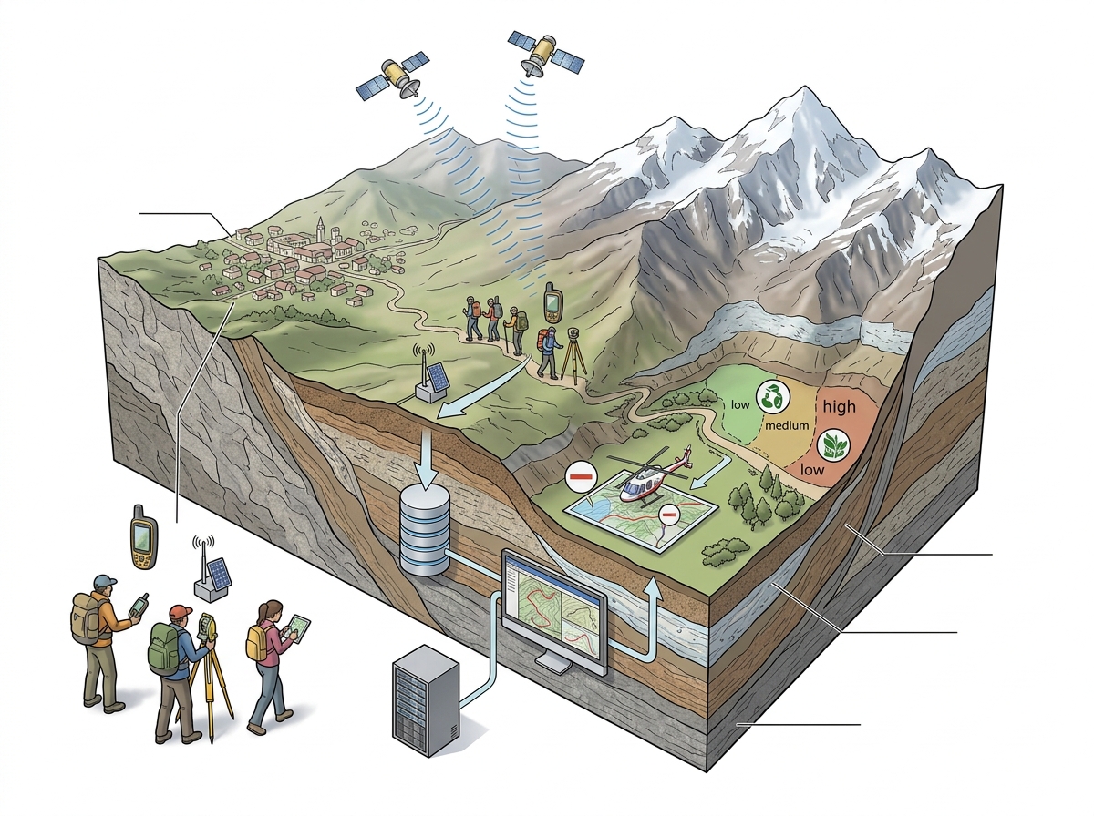
- GPS/GIS mapping involves the use of satellite-based positioning systems (GPS) and geographic information systems (GIS) to create digital representations of trekking routes, including terrain, elevation, landmarks, and critical infrastructure.
- This process includes field surveys using GPS devices to record coordinates, ground-truthing to validate data, and GIS analysis to generate layered maps with attributes such as slope, water sources, and emergency access points.
- The resulting digital maps enable real-time navigation for trekkers, even in areas with poor network connectivity, through offline-enabled mobile applications.
- Emergency response teams can utilize these maps for rapid location identification, resource allocation, and rescue operations during accidents or natural disasters.
- The project also includes identifying suitable locations for campsites, waste disposal units, and sanitation facilities along the routes to promote sustainable tourism practices.
- By integrating environmental data (e.g., fragile ecosystems, wildlife corridors), the mapping supports eco-sensitive tourism planning and minimizes human impact on sensitive Himalayan habitats.
- Uttarakhand’s effort to develop an offline GPS navigation app for trekkers positions it as a pioneer in leveraging geospatial technology for adventure tourism management in India.
Key Features
| Feature | Significance |
|---|---|
| GPS/GIS Mapping of 100 trekking routes | Enables precise digital mapping of trails, enhancing navigational accuracy and safety for trekkers. |
| Offline GPS Navigation App | Provides route information without internet connectivity, critical for remote Himalayan terrains. |
| Identification of Camp Sites & Sanitation Points | Ensures sustainable tourism by locating suitable rest areas and waste management infrastructure along routes. |
| Local Employment Generation | Promotes homestays, guiding services, and tourism-related livelihoods in remote mountain communities. |
| Emergency Response Integration | Facilitates faster rescue operations by providing real-time location data during distress situations. |
Why it Matters
Economic
- Boosts adventure tourism in Uttarakhand, attracting domestic and international trekkers to lesser-known routes.
- Creates employment opportunities in hospitality, guiding, and allied sectors in rural Himalayan regions.
- Enhances revenue generation through extended tourist stays and ancillary services like homestays and local crafts.
Environmental
- Supports sustainable tourism by identifying ecologically sensitive zones and promoting responsible trekking practices.
- Reduces environmental degradation through planned waste disposal and sanitation infrastructure along routes.
Strategic
- Strengthens disaster preparedness by integrating route mapping with emergency response systems in fragile Himalayan ecosystems.
- Enhances border-area tourism, fostering socio-economic development in strategically important regions.
Technological
- Demonstrates the application of geospatial technologies (GPS/GIS) in governance for public safety and tourism management.
- Sets a precedent for other Himalayan states to adopt similar digital mapping initiatives for adventure tourism.
Challenges
1. Geospatial Data Accuracy
- Ensuring high-precision mapping in rugged terrains prone to landslides and rapid landscape changes.
- Mitigating errors in GPS/GIS data that could mislead trekkers and compromise safety.
UPSC Link: Geospatial Policy 2021
2. Connectivity Constraints
- Limited mobile network coverage in remote Himalayan regions necessitates offline-capable navigation solutions.
- Dependence on battery-powered devices in areas with unreliable power supply.
UPSC Link: Digital Divide in Mountain Regions
3. Environmental Vulnerability
- Risk of over-tourism in fragile ecosystems if route mapping inadvertently increases footfall in sensitive zones.
- Need for strict adherence to carrying capacity norms to prevent ecological damage.
UPSC Link: Himalayan Ecosystem Conservation
4. Local Community Integration
- Ensuring equitable participation of local communities in tourism benefits without displacement or exploitation.
- Balancing traditional knowledge with modern technological solutions for sustainable tourism.
UPSC Link: Community-Based Tourism
5. Funding and Maintenance
- Sustaining long-term maintenance of infrastructure (campsites, sanitation) post-implementation.
- Securing budgetary allocations for periodic updates to digital maps and navigation apps.
UPSC Link: Tourism Infrastructure Financing
Challenges — UPSC Perspective
| Issue | Concern |
|---|---|
| Data Precision | Accuracy of GPS/GIS mapping in dynamic Himalayan terrains. |
| Network Dependency | Offline functionality challenges in remote areas with poor connectivity. |
| Ecological Impact | Risk of environmental degradation due to increased tourist footfall. |
| Community Benefits | Ensuring equitable distribution of tourism revenue among local stakeholders. |
| Regulatory Compliance | Adherence to national geospatial policies and environmental laws. |
Way Forward
- Develop a phased implementation plan for GPS/GIS mapping, prioritizing high-risk and high-traffic routes first.
- Collaborate with ISRO and Survey of India for high-accuracy geospatial data and validation.
- Establish a dedicated emergency response unit integrated with the navigation app for real-time distress alerts.
- Conduct capacity-building workshops for local guides and homestay owners on digital tools and sustainable practices.
- Formulate a monitoring framework to assess ecological impact and adjust tourism policies accordingly.
- Partner with telecom providers to enhance network coverage along key trekking corridors.
- Launch public awareness campaigns to educate trekkers on responsible tourism and emergency protocols.
UPSC Value Addition
Keywords for Mains Answer-Writing
GPS-GIS mapping · adventure tourism · Uttarakhand tourism policy · Himalayan ecology conservation · tourism infrastructure · emergency response systems · digital public infrastructure · sustainable tourism · trekking route safety · geospatial technology in governance
Concept Flow
State Government identifies tourism potential in remote Himalayan regions → → Initiation of GPS/GIS mapping project for 100 trekking routes → → Field surveys and data collection by specialized teams → → Development of offline GPS navigation app with emergency features → → Deployment of app and infrastructure (campsites, sanitation) → → Enhanced tourist safety, economic benefits, and environmental sustainability → → Periodic updates and policy refinements based on feedback and ecological assessments
Prelims Practice Questions
Q1. Consider the following statements regarding GPS-GIS mapping in Uttarakhand:
1. The initiative aims to map 100 major trekking routes using GPS-GIS technology.
2. The project will develop an offline and online GPS navigation app for trekkers.
3. The mapping will include identification of suitable locations for camp sites, dustbins, and toilets along trekking routes.
4. The project is being implemented by the Ministry of Tourism, Government of India, in collaboration with Uttarakhand.
How many of the above statements are correct?
- Only one
- Only two
- Only three
- All four
Answer: Only three — Statements 1, 2, and 3 are correct as per the report. Statement 4 is incorrect because the project is being implemented by the Uttarakhand Tourism Development Council, not the Ministry of Tourism, Government of India.
Q2. Assertion (A): GPS-GIS mapping enhances the safety and accessibility of trekking routes in Uttarakhand.
Reason (R): The mapping provides real-time navigation assistance and supports emergency response operations.
In the context of the above statements, which of the following is correct?
- Both A and R are true, and R is the correct explanation of A.
- Both A and R are true, but R is not the correct explanation of A.
- A is true, but R is false.
- A is false, but R is true.
Answer: Both A and R are true, and R is the correct explanation of A. — Both Assertion (A) and Reason (R) are true. GPS-GIS mapping indeed enhances safety and accessibility by providing real-time navigation and supporting emergency response operations. The Reason (R) correctly explains the Assertion (A).
Q3. Match the following initiatives with their respective objectives:
Column I (Initiative) | Column II (Objective)
———————————————–|——————————————-
A. GPS-GIS mapping of trekking routes | 1. To promote adventure tourism
B. Offline GPS navigation app | 2. To ensure real-time navigation support
C. Identification of camp sites along routes | 3. To enhance tourist safety and comfort
D. Promotion of home-stays for local youth | 4. To create employment opportunities
Select the correct match:
- A-1, B-2, C-3, D-4
- A-2, B-3, C-4, D-1
- A-3, B-1, C-4, D-2
- A-4, B-2, C-1, D-3
Answer: A-1, B-2, C-3, D-4 — A. GPS-GIS mapping of trekking routes is primarily aimed at promoting adventure tourism (1). B. Offline GPS navigation app ensures real-time navigation support (2). C. Identification of camp sites along routes enhances tourist safety and comfort (3). D. Promotion of home-stays for local youth creates employment opportunities (4).
Mains Practice Question
✍ Discuss the significance of GPS-GIS mapping in enhancing adventure tourism and ensuring ecological sustainability in the Himalayan region. Also, examine the potential challenges in implementing such initiatives in ecologically fragile terrains. (15 Marks)
Approach: MODEL-ANSWER SKELETON:
1. **Introduction (2 marks)**: Define GPS-GIS mapping and its relevance in adventure tourism. Briefly mention Uttarakhand’s initiative as a case study.
2. **Significance in Adventure Tourism (5 marks)**:
– **Safety and Accessibility**: Real-time navigation, route clarity, and emergency response integration.
– **Tourist Experience**: Offline app support in remote areas with poor network connectivity.
– **Economic Benefits**: Creation of local employment (guides, home-stays, hospitality services) and promotion of sustainable tourism.
– **Data-Driven Planning**: Identification of high-traffic routes, crowd management, and infrastructure development.
3. **Ecological Sustainability (4 marks)**:
– **Minimising Environmental Impact**: Designation of camp sites, waste management (dustbins), and sanitation facilities to reduce pollution.
– **Biodiversity Conservation**: Mapping of sensitive ecological zones to avoid disturbances.
– **Climate Resilience**: Data on weather patterns and terrain stability for disaster risk reduction.
4. **Challenges in Implementation (4 marks)**:
– **Technological Barriers**: Limited internet connectivity in remote Himalayan terrains.
– **Ecological Fragility**: Risk of over-tourism and habitat degradation despite mapping.
– **Community Participation**: Ensuring local stakeholder involvement without exploitation.
– **Regulatory and Ethical Concerns**: Balancing tourism promotion with environmental protection laws (e.g., Wildlife Protection Act, 1972; Forest Rights Act, 2006).
5. **Conclusion (2 marks)**: Summarise the dual role of GPS-GIS mapping in balancing tourism growth and ecological preservation. Highlight the need for integrated policy frameworks and multi-stakeholder collaboration.
Source: amarujala.com
Uttarakhand PCS (UKPSC) — State PCS Practice
Prelims: Which of the following is the primary objective of the GPS-GIS mapping initiative launched for the 100 major trekking routes in Uttarakhand, as announced by Chief Minister Pushkar Singh Dhami?
- A. To promote adventure tourism and attract international trekkers
- B. To ensure safety, monitor environmental impact, and facilitate sustainable trekking infrastructure
- C. To replace traditional trekking guides with digital navigation systems
- D. To restrict trekking activities to designated routes only
Answer: B. To ensure safety, monitor environmental impact, and facilitate sustainable trekking infrastructure — The initiative aims to enhance safety, track environmental impact, and develop sustainable trekking infrastructure in Uttarakhand.
Mains: Discuss the significance of the GPS-GIS mapping initiative for Uttarakhand’s 100 major trekking routes in the context of sustainable tourism and environmental conservation. Highlight the role of technology in achieving these objectives.
Generated by AanyaAi for educational purpose.
Related guides on our sites
- Anthropology VS PSIR
- Best PSIR optional coaching
- Best PSIR optional coaching online
- Best geography optional coaching

- उत्तराखंड में 100 प्रमुख ट्रेकिंग रूट की जीपीएस-जीआईएस मैपिंग: सीएम धामी ने किया शुभारंभ - September 18, 2026
- CM Dhami Launches GPS-GIS Mapping of 100 Key Trekking Routes in Uttarakhand - September 18, 2026
- यूएन रिपोर्ट: ईरान में अमेरिका के युद्ध अपराधों के प्रमाण मिले, जानें पूरा मामला - September 18, 2026

No Comments