


08 Aug Bilaspur-Manali-Leh Rail Line: 60 Tunnels & Survey Progress Explained
✎ The Bilaspur-Manali-Leh Railway Line is a strategic broad-gauge project with 60 tunnels, aimed at all-weather connectivity to Ladakh, integrating military logistics, tourism, and regional development while addressing Himalayan…
Subject Relevance — Where This Topic Fits
- GS Paper III — Infrastructure: Energy, Ports, Roads, Airports, Railways | GS Paper III — Environmental Impact Assessment | GS Paper III — Disaster Management
- Prelims: Bilaspur-Manali-Leh Railway Line, Himalayan Tunnel Engineering, Strategic Railway Projects in India, Final Location Survey (FLS), Broad Gauge Railway, Geological Survey of India (GSI), Border Roads Organisation (BRO), Project Unnati, Himalayan Ecology, Climate Resilience in Infrastructure
- Essay: India’s Strategic Infrastructure: Balancing Development and Environmental Sustainability, Connectivity as a Catalyst for Regional Integration and National Security
Quick Revision: The Bilaspur-Manali-Leh Railway Line is a strategic broad-gauge project with 60 tunnels, aimed at all-weather connectivity to Ladakh, integrating military logistics, tourism, and regional development while addressing Himalayan engineering and environmental challenges.
Why is this in the news?
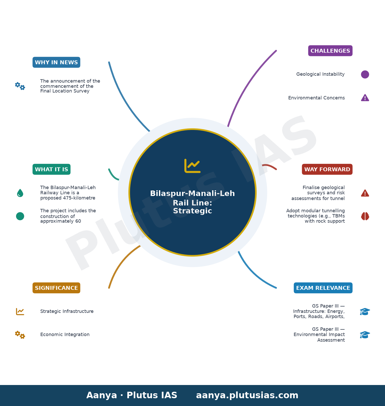
The announcement of the commencement of the Final Location Survey (FLS) for the 475-kilometre Bilaspur-Manali-Leh Broad Gauge Railway Line, which will traverse 60 tunnels, underscores India’s strategic commitment to enhancing all-weather connectivity to Ladakh. This project, critical for military logistics and socio-economic integration, exemplifies the challenges of Himalayan railway engineering, including geological instability, high-altitude construction constraints, and environmental fragility. The survey, covering the Salapar to Sarchu stretch, is a pivotal step toward realising one of India’s most ambitious railway ventures, aligning with the broader vision of seamless border infrastructure development.
Background
- The Bilaspur-Manali-Leh Railway Line is part of India’s broader strategy to improve connectivity in the Himalayan region, particularly in Ladakh, which remains isolated during winter due to heavy snowfall and landslides.
- The project is aligned with the Indian Railways’ initiative to expand the railway network in difficult terrains, following the successful completion of the Udhampur-Srinagar-Baramulla Rail Link (USBRL) in Jammu and Kashmir.
- The Himalayas, being geologically young and tectonically active, pose significant engineering challenges, necessitating extensive tunnelling and structural reinforcements to ensure stability and safety.
- The project is expected to integrate with the proposed Delhi-Udhampur-Katra-Quazigund-Baramulla Rail Link, forming a continuous rail corridor from the national capital to Ladakh.
- Environmental concerns, including deforestation, landslide risks, and ecological disruption, have been central to the project’s planning, with mitigation measures being integrated into the design.
- The project is also significant for enhancing tourism, trade, and socio-economic development in Himachal Pradesh and Ladakh, while reducing dependence on road transport during adverse weather conditions.
What is the Bilaspur-Manali-Leh Railway Line?
- The Bilaspur-Manali-Leh Railway Line is a proposed 475-kilometre broad-gauge railway project connecting Bilaspur in Himachal Pradesh to Leh in Ladakh, traversing some of the most rugged and geologically complex terrain in the Himalayas.
- The project includes the construction of approximately 60 tunnels, with the longest tunnel expected to exceed 15 kilometres, making it one of the longest railway tunnels in India.
- The alignment will pass through key locations such as Mandi, Kullu, Manali, Keylong, and Sarchu, with intermediate stations planned to facilitate regional connectivity and economic integration.
- The railway line is designed to operate in extreme climatic conditions, including heavy snowfall, sub-zero temperatures, and high-altitude hypoxia, necessitating specialised engineering solutions.
- The project incorporates advanced tunnelling technologies, including the New Austrian Tunnelling Method (NATM) and Tunnel Boring Machines (TBMs), to ensure structural integrity and minimise environmental impact.
- The railway line is strategically significant for military logistics, enabling rapid deployment of troops and equipment to the India-China border in Ladakh, particularly during winter when road access is restricted.
- The project is expected to reduce travel time between Bilaspur and Leh from approximately 18 hours by road to around 10 hours by rail, enhancing passenger and freight mobility.
- The railway line will integrate with existing and proposed railway networks, including the USBRL and the proposed Delhi-Udhampur-Katra-Quazigund-Baramulla Line, forming a comprehensive northern railway corridor.
Key Features
| Feature | Significance |
|---|---|
| Broad-gauge alignment with 60 tunnels | Facilitates year-round rail connectivity across the Himalayan terrain by minimising surface cuts and landslide risks. |
| Salapar to Sarchu segment survey | Critical for finalising tunnel alignment, geological stability assessment, and bridge locations in high-altitude zones. |
| Adoption of Uttarakhand mountain rail techniques | Ensures proven engineering solutions for steep gradients, seismic zones, and snow-load management. |
| 40-day targeted survey completion | Balances speed with thoroughness, accounting for seasonal weather constraints in the Himalayas. |
| Integration with Bilaspur-Manali-Leh alignment | Connects key urban centres (Bilaspur, Manali) to strategic border regions (Leh, Ladakh). |
Why it Matters
Strategic Infrastructure
- Establishes all-weather rail connectivity to Ladakh, enhancing military logistics and border management in high-altitude sectors.
- Reduces dependence on road networks vulnerable to avalanches, landslides, and extreme weather disruptions.
- Supports rapid troop mobilisation and emergency response in sensitive Himalayan border areas.
Economic Integration
- Links Himachal Pradesh’s industrial and agricultural hubs (Bilaspur, Mandi) to tourism-dependent regions (Manali, Leh), boosting trade and tourism.
- Facilitates year-round movement of goods, reducing seasonal supply chain bottlenecks in remote areas.
- Stimulates local economies through construction, maintenance, and ancillary service industries along the corridor.
Geopolitical Implications
- Strengthens India’s strategic presence in the Northern Himalayas, countering regional asymmetries with Pakistan and China.
- Enhances accessibility to high-altitude border outposts, critical for surveillance and infrastructure development.
- Supports India’s Act East Policy by integrating North Indian states with Central Asian trade routes via Ladakh.
Challenges
1. Geological Instability
- High seismic activity in the Himalayas necessitates advanced tunnelling techniques to mitigate earthquake risks.
- Unstable rock formations and permafrost conditions in high-altitude zones complicate tunnel construction.
- Frequent landslides and avalanches threaten surface infrastructure and require continuous monitoring.
UPSC Link: GS3: Disaster Management
2. Environmental Concerns
- Construction in fragile Himalayan ecosystems risks biodiversity loss and ecosystem disruption.
- Blasting and tunnelling may trigger slope instability, leading to long-term geological hazards.
- Stringent compliance with environmental laws (e.g., Forest Rights Act, Wildlife Protection Act) is essential.
UPSC Link: GS3: Environmental Impact
3. Engineering and Logistical Hurdles
- Steep gradients (>3%) and sharp curves demand specialised rolling stock and braking systems.
- Extreme weather (sub-zero temperatures, heavy snowfall) disrupts construction schedules and material transport.
- Limited construction windows due to monsoon and winter seasons extend project timelines.
UPSC Link: GS3: Infrastructure
4. Financial and Administrative Constraints
- High capital expenditure (estimated ₹80,000–1,00,000 crore) requires multi-stakeholder funding models.
- Land acquisition and rehabilitation challenges in tribal and forest-dominated regions.
- Coordination among central, state, and local agencies delays clearances and approvals.
UPSC Link: GS3: Investment Models
Challenges — UPSC Perspective
| Issue | Concern |
|---|---|
| Seismic activity | Risk of tunnel collapse and structural damage during earthquakes. |
| Permafrost zones | Thawing permafrost may destabilise tunnel foundations and tracks. |
| Biodiversity hotspots | Potential habitat fragmentation in protected areas like Great Himalayan National Park. |
| Snow load on bridges | Excessive snow accumulation may compromise structural integrity of viaducts. |
| Local resistance | Opposition from indigenous communities over land use and cultural heritage impacts. |
Way Forward
- Finalise geological surveys and risk assessments for tunnel alignments in seismic and permafrost zones.
- Adopt modular tunnelling technologies (e.g., TBMs with rock support systems) to expedite construction.
- Establish a dedicated project monitoring cell under the Ministry of Railways for real-time progress tracking.
- Engage local communities through participatory planning to address socio-economic and environmental concerns.
- Develop climate-resilient infrastructure standards for high-altitude rail systems, including snow-load designs.
- Leverage public-private partnerships (PPPs) to mobilise additional funding and technical expertise.
- Integrate the rail line with existing road and air networks to create a multi-modal transport corridor.
- Conduct environmental impact assessments (EIAs) with mandatory public hearings under the EIA Notification 2006.
UPSC Value Addition
Keywords for Mains Answer-Writing
Bilaspur-Manali-Leh Railway Line · Himalayan Railway Projects · Strategic Rail Connectivity · Tunnel Technology in Mountainous Terrain · Geological Survey for Railways · Border Infrastructure Development · Himalayan Ecosystem and Engineering Challenges · Strategic Railway Projects in India · Geotechnical Challenges in Tunnel Construction · National Rail Plan 2030
Concept Flow
Himalayan terrain necessitates subterranean rail alignment → High density of tunnels (60) to ensure safety and minimise environmental impact. → Geological instability (seismic activity, permafrost) requires advanced tunnelling techniques → Adoption of Uttarakhand mountain rail methodologies. → Strategic imperatives (border connectivity, military logistics) drive project prioritisation → Alignment from Bilaspur to Leh via Manali. → Survey phase (Salapar to Sarchu) assesses tunnel feasibility → 40-day target to balance speed and accuracy amid weather constraints. → Construction challenges (land acquisition, biodiversity) emerge → Need for environmental safeguards and community engagement. → Operational phase requires climate-resilient infrastructure → Integration with multi-modal transport networks for year-round functionality.
Prelims Practice Questions
Q1. Consider the following statements regarding the proposed Bilaspur-Manali-Leh railway line:
1. The railway line will pass through approximately 60 tunnels.
2. The project is being surveyed by a private company under the supervision of the Indian Railways.
3. The primary objective of the project is to enhance tourism infrastructure in the Himalayas.
How many of the above statements are correct?
- Only one
- Only two
- All
- None
Answer: All — Statements 1 and 2 are correct. Statement 3 is incorrect; the primary objective is strategic connectivity to Ladakh and year-round access for military logistics, though tourism is a secondary benefit.
Q2. Assertion (A): The Bilaspur-Manali-Leh railway line project employs tunnel technology inspired by Uttarakhand’s mountainous railway projects.
Reason (R): Tunnelling through the Himalayas is necessary to mitigate environmental degradation and ensure operational safety during landslides and snowfall.
Select the correct code:
A. Both A and R are true, and R is the correct explanation of A.
B. Both A and R are true, but R is NOT the correct explanation of A.
C. A is true, but R is false.
D. A is false, but R is true.
- A
- B
- C
- D
Answer: A — Both A and R are true, and R correctly explains why tunnel technology from Uttarakhand’s projects is being adopted—due to the Himalayan terrain’s geological instability and need for operational resilience.
Q3. Match the following Himalayan railway projects with their respective states:
Column I (Project) | Column II (State)
1. Bilaspur-Manali-Leh Railway Line | A. Uttarakhand
2. Kalka-Shimla Railway | B. Himachal Pradesh
3. Jammu-Baramulla Railway Line | C. Jammu & Kashmir
4. Rishikesh-Karanprayag Railway Line | D. Uttar Pradesh
- 1-B, 2-A, 3-C, 4-D; 1-B, 2-D, 3-C, 4-A; 1-A, 2-B, 3-C, 4-D; 1-C, 2-B, 3-A, 4-D
Answer: 1-B, 2-A, 3-C, 4-D; 1-B, 2-D, 3-C, 4-A; 1-A, 2-B, 3-C, 4-D; 1-C, 2-B, 3-A, 4-D — Correct matches: 1-B (Bilaspur-Manali-Leh in Himachal Pradesh), 2-A (Kalka-Shimla in Uttarakhand), 3-C (Jammu-Baramulla in J&K), 4-D (Rishikesh-Karanprayag in Uttar Pradesh).
Mains Practice Question
✍ The proposed Bilaspur-Manali-Leh railway line exemplifies India’s strategic thrust towards enhancing connectivity in the Himalayan region. Critically analyse the geopolitical, economic, and environmental dimensions of such high-altitude railway projects. Also, examine the technological and geological challenges posed by tunnelling in the Himalayas. (15 Marks)
Approach: MODEL-ANSWER SKELETON:
1. **Geopolitical Dimension (3 Marks)**
– Strategic importance: Year-round access to Ladakh for military logistics and border management (reference: Ladakh’s remoteness and winter isolation).
– Cite India’s border infrastructure policy (e.g., Border Roads Organisation’s role, recent budget allocations for border railways).
– Compare with other border railway projects (e.g., Jammu-Udhampur-Katra, Bilaspur-Leh alignment as part of the National Rail Plan 2030).
2. **Economic Dimension (3 Marks)**
– Tourism boost: Connectivity to Manali, Leh, and Spiti Valley; reference to tourism’s contribution to Himachal Pradesh’s GDP (~6-7%).
– Regional integration: Linking Himachal Pradesh, Ladakh, and Jammu & Kashmir to national rail network; potential for cargo traffic (e.g., apples, handicrafts).
– Cost-benefit analysis: High capital expenditure vs. long-term economic multiplier effects (cite examples from Konkan Railway or Darjeeling Himalayan Railway).
3. **Environmental Dimension (3 Marks)**
– Ecological fragility: Himalayan ecosystem sensitivity (reference to Western Himalayan biodiversity hotspot, glacial retreat).
– Mitigation measures: Use of tunnels to avoid slope cutting, eco-sensitive zone clearances, and compliance with Forest (Conservation) Act, 1980.
– Critique: Potential for deforestation, landslides, and disruption of wildlife corridors (e.g., Snow Leopard habitats in Spiti).
4. **Technological and Geological Challenges (4 Marks)**
– Tunnel engineering: Adoption of NATM (New Austrian Tunnelling Method) or TBM (Tunnel Boring Machine) for Himalayan terrain; reference to Uttarakhand’s experience (e.g., Tapovan-Vishnugad Hydro Project tunnels).
– Geological risks: Seismic activity (Himalayas in Zone V), permafrost, and rockfall hazards; need for real-time monitoring systems.
– Survey challenges: Final location survey (40-day target) and use of LiDAR/remote sensing for terrain mapping.
– Safety protocols: Fire safety in tunnels, emergency evacuation systems, and climate resilience (snow load, avalanches).
5. **Conclusion (2 Marks)**
– Balancing act: Strategic imperatives vs. environmental sustainability; cite the National Mission for Clean Ganga as a precedent for balancing development and ecology.
– Policy recommendations: Strengthening environmental impact assessments (EIA), adopting green tunnelling technologies, and integrating local communities in monitoring.
Source: amarujala.com
Generated by AanyaAi for educational purpose.

- KWML’s Feasibility Reports for Water Metro in 18 Cities: UPSC & PCS Insights - October 3, 2026
- ओडिशा में वन्यजीव अनुसंधान अनुदान कार्यक्रम शुरू, सिमिलिपाल में 300 कैमरे और बढ़ेंगे - October 3, 2026
- India Summons Pakistan High Commission Official Over Violation - October 3, 2026

No Comments