


09 Aug Karnataka Launches AI-Powered Digital Crop Survey for Accurate Data
✎ The Composite Digital Crop Survey (CDCS) in Karnataka integrates AI, ML, high-resolution satellite imagery, SAR, drone surveys, and GIS to enhance the precision and reliability of agricultural data collection, building upon the…
Subject Relevance — Where This Topic Fits
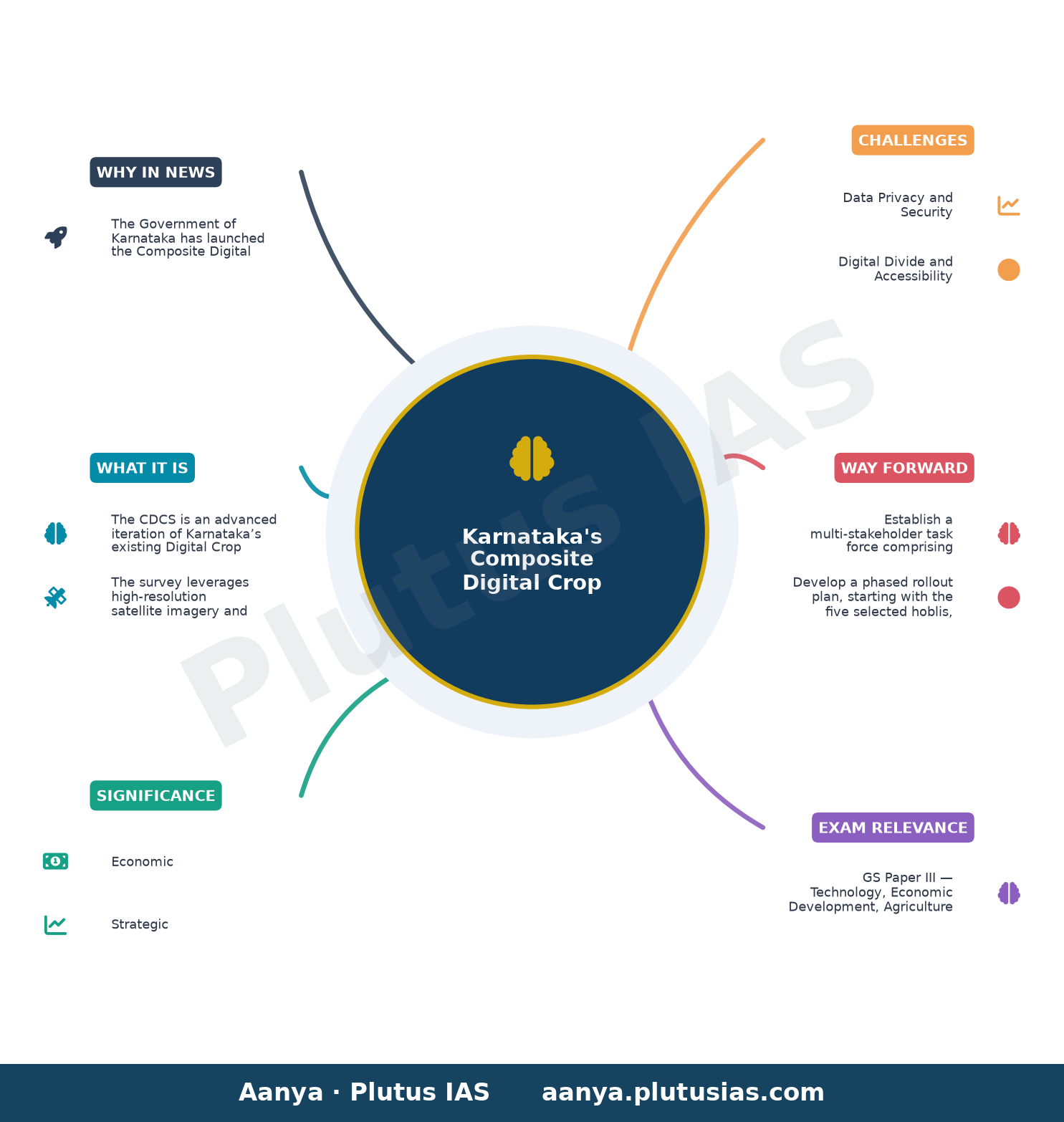
- GS Paper III — Technology, Economic Development, Agriculture
- Prelims: Digital Public Infrastructure, Geospatial Technology, Artificial Intelligence in Governance, Agricultural Data Analytics, Synthetic Aperture Radar (SAR), GIS-based Mobile Applications, Precision Agriculture
- Essay: The Role of Technology in Transforming Governance: A Case Study of Karnataka’s Agricultural Reforms, Data-Driven Policymaking: Balancing Innovation with Inclusivity
Quick Revision: The Composite Digital Crop Survey (CDCS) in Karnataka integrates AI, ML, high-resolution satellite imagery, SAR, drone surveys, and GIS to enhance the precision and reliability of agricultural data collection, building upon the existing Digital Crop Survey (DCS) introduced in 2018.
Why is this in the news?
The Government of Karnataka has launched the Composite Digital Crop Survey (CDCS), a pilot initiative integrating advanced technologies such as Artificial Intelligence (AI), Machine Learning (ML), high-resolution satellite imagery, Synthetic Aperture Radar (SAR), drone surveys, and GIS data to enhance the accuracy and reliability of agricultural data collection. This initiative builds upon the existing Digital Crop Survey (DCS), introduced in 2018, and aims to strengthen evidence-based governance and policymaking in the agricultural sector.
Background
- The Digital Crop Survey (DCS) was introduced by Karnataka in 2018 as a GIS-based mobile application to collect authenticated plot-level crop data, replacing traditional manual surveys.
- Agricultural data collection in India has historically relied on manual methods, which are prone to errors, delays, and inconsistencies due to human intervention.
- The integration of geospatial technologies and AI in governance has gained momentum globally, particularly in sectors like agriculture, urban planning, and disaster management.
- Karnataka has been a frontrunner in adopting digital governance solutions, exemplified by initiatives such as the Bhoomi project for land records digitisation.
- The pilot phase of the CDCS will be implemented in five selected hoblis, representing diverse geographical divisions of the state, to ensure comprehensive validation.
- The initiative aligns with the broader national agenda of leveraging technology for sustainable agricultural development and climate-resilient farming practices.
What is the Composite Digital Crop Survey (CDCS)?
- The CDCS is an advanced iteration of Karnataka’s existing Digital Crop Survey (DCS), designed to enhance the accuracy, reliability, and scientific validation of agricultural data through the integration of cutting-edge technologies.
- The survey leverages high-resolution satellite imagery and Synthetic Aperture Radar (SAR) to capture detailed land-use and crop patterns, overcoming limitations posed by cloud cover or terrain.
- Drone surveys are employed to supplement satellite data, particularly in small and fragmented agricultural plots, ensuring granular and precise data collection.
- Geographic Information System (GIS) data forms the backbone of the survey, enabling spatial analysis and mapping of crop distribution across the state.
- Artificial Intelligence (AI) and Machine Learning (ML) algorithms are utilised to process vast datasets, identify crop types, detect anomalies, and predict agricultural trends with high accuracy.
- The pilot phase will be conducted in five hoblis, selected to represent Karnataka’s diverse agro-climatic zones, ensuring the model’s adaptability and scalability.
- The initiative aims to reduce manual errors, streamline data collection, and provide real-time, authenticated crop data to support evidence-based policymaking.
- By integrating these technologies, the CDCS seeks to enhance food security, optimise resource allocation, and improve the resilience of Karnataka’s agricultural sector.
Key Features
| Feature | Significance |
|---|---|
| High-resolution satellite imagery | Enables precise identification of crop types, acreage, and health across large agricultural landscapes with minimal ground intervention. |
| Synthetic Aperture Radar (SAR) | Provides all-weather, day-night imaging capability to penetrate cloud cover and assess moisture content in soil and crops. |
| Drone surveys | Facilitates hyper-local, real-time data collection in inaccessible or smallholder-dominated terrains for granular crop monitoring. |
| GIS integration | Spatial mapping of agricultural plots with cadastral data ensures accurate geo-referencing and boundary delineation for policy targeting. |
| Artificial Intelligence (AI) and Machine Learning (ML) | Automates image classification, anomaly detection, and predictive analytics to enhance data reliability and reduce human error. |
| Composite Digital Crop Survey (CDCS) model | Unifies multi-source data streams into a unified framework, replacing the earlier GIS-based DCS (2018) for improved scalability and robustness. |
Why it Matters
Economic
- Enhances agricultural productivity estimates by reducing data gaps and inaccuracies in crop statistics, directly influencing GDP contribution assessments from the sector.
- Supports precision agriculture, enabling farmers to optimise resource use (water, fertilisers) and reduce input costs through data-driven decision-making.
- Facilitates better credit access for farmers by providing verifiable, real-time land and crop data to financial institutions for loan disbursal.
Strategic
- Strengthens India’s food security architecture by improving early warning systems for droughts, floods, or pest infestations through AI-driven crop health monitoring.
- Positions Karnataka as a pioneer in leveraging emerging technologies for governance, potentially serving as a model for other states in India’s agricultural digital transformation.
Technological
- Demonstrates the integration of space-based remote sensing (ISRO’s satellites), drone technology, and AI/ML in a single governance framework, showcasing India’s indigenous technological capabilities.
- Reduces dependency on manual surveys, which are prone to errors, delays, and inconsistencies, thereby improving the credibility of agricultural data.
Policy and Governance
- Enables evidence-based policymaking by providing granular, real-time data on crop patterns, land use changes, and agricultural trends for targeted interventions.
- Supports the implementation of schemes like PM-KISAN, PM-FME, and state-level agricultural subsidies by ensuring accurate beneficiary identification and exclusion of ineligible claims.
Social
- Empowers small and marginal farmers by providing them with digital land records and crop data, reducing information asymmetry in agricultural markets.
- Enhances transparency in agricultural subsidies and insurance claims, reducing disputes and improving trust in government schemes.
Challenges
1. Data Privacy and Security
- Risk of unauthorised access or misuse of sensitive farm-level data, including land records and crop yields, necessitating robust cybersecurity measures.
- Compliance with the Digital Personal Data Protection Act, 2023, to ensure ethical handling of farmer data collected through AI and drones.
UPSC Link: GS Paper 3: Science & Tech, GS Paper 2: Governance
2. Digital Divide and Accessibility
- Limited internet connectivity and digital literacy in rural Karnataka may hinder the effective utilisation of AI-powered surveys, particularly among smallholder farmers.
- Need for capacity-building initiatives to train farmers and local officials in interpreting and utilising AI-generated agricultural data.
UPSC Link: GS Paper 1: Social Issues, GS Paper 3: Rural Development
3. High Implementation Costs
- Initial capital expenditure for procuring satellite imagery, drones, and AI/ML tools, as well as recurring costs for data processing and maintenance.
- Potential fiscal strain on state exchequers, requiring efficient public-private partnerships or central government funding for scalability.
UPSC Link: GS Paper 3: Budgeting, GS Paper 2: Centre-State Relations
4. Interoperability and Standardisation
- Challenges in integrating data from diverse sources (satellites, drones, ground surveys) into a unified platform due to varying formats and resolutions.
- Need for standardised protocols to ensure compatibility with national databases like the National Land Records Modernisation Programme (NLRMP).
UPSC Link: GS Paper 3: IT & Governance
5. Ethical and Bias Concerns in AI
- Risk of algorithmic bias in AI models if trained on unrepresentative data, leading to inaccuracies in crop classification or yield predictions.
- Requirement for transparency in AI decision-making to avoid farmer distrust and ensure accountability in policy outcomes.
UPSC Link: GS Paper 4: Ethics, GS Paper 3: Science & Tech
6. Regulatory and Legal Hurdles
- Ambiguities in land ownership records and disputes over plot boundaries may complicate the integration of GIS data with AI surveys.
- Need for clear legal frameworks governing drone operations, data ownership, and liability in case of errors or omissions.
UPSC Link: GS Paper 2: Governance, GS Paper 3: Agriculture
Challenges — UPSC Perspective
| Issue | Concern |
|---|---|
| Data Privacy | Unauthorised access or misuse of farmer data collected via AI and drones. |
| Digital Divide | Limited rural internet connectivity and digital literacy impeding survey effectiveness. |
| Cost | High initial and recurring expenditures for technology deployment and maintenance. |
| Interoperability | Difficulty in integrating heterogeneous data sources into a unified platform. |
| AI Bias | Potential inaccuracies in crop classification due to unrepresentative training data. |
| Regulatory Gaps | Ambiguities in land records and drone operations complicating legal compliance. |
Way Forward
- Establish a multi-stakeholder task force comprising agricultural scientists, technologists, and policymakers to oversee the pilot phase and address implementation bottlenecks.
- Develop a phased rollout plan, starting with the five selected hoblis, followed by gradual expansion based on lessons learned and resource availability.
- Invest in rural digital infrastructure, including high-speed internet connectivity and digital literacy programs, to ensure equitable access to AI-powered surveys.
- Collaborate with ISRO, private space agencies, and drone manufacturers to secure cost-effective, high-resolution satellite and aerial data for sustained survey operations.
- Implement robust data governance frameworks, including encryption, anonymisation, and strict access controls, to safeguard farmer privacy and comply with the Digital Personal Data Protection Act.
- Standardise data formats and protocols to ensure interoperability with national databases like NLRMP and state-level agricultural registries.
- Pilot AI bias mitigation techniques, such as diverse training datasets and explainable AI tools, to enhance the reliability of crop classification models.
- Conduct periodic impact assessments to evaluate the economic, social, and environmental outcomes of the CDCS model, feeding insights into future policy revisions.
UPSC Value Addition
Keywords for Mains Answer-Writing
Digital Public Infrastructure for Agriculture · AI and Machine Learning in governance · Composite Digital Crop Survey (CDCS) · GIS and remote sensing in agriculture · Drone technology in crop survey · Synthetic Aperture Radar (SAR) for agriculture · Evidence-based policymaking in agriculture · Agricultural data governance and transparency · Precision agriculture and digital transformation · Karnataka’s agricultural innovation model · Crop insurance and digital land records · National Mission on Sustainable Agriculture (NMSA)
Concept Flow
Karnataka’s agricultural sector faces challenges in accurate crop data collection due to manual surveys and data gaps. → The Digital Crop Survey (DCS, 2018) introduced GIS-based mobile apps to improve data authenticity but lacked scientific validation. → Emerging technologies (AI, ML, SAR, drones) are integrated into the Composite Digital Crop Survey (CDCS) to enhance accuracy and scalability. → High-resolution satellite imagery and AI-driven analytics enable real-time, all-weather crop monitoring and predictive insights. → Granular, geo-referenced data supports evidence-based policymaking, precision agriculture, and targeted subsidies. → Implementation challenges (data privacy, digital divide, costs) necessitate robust governance frameworks and capacity-building measures. → Successful pilot in five hoblis could serve as a model for national adoption, aligning with India’s digital governance and agricultural transformation goals.
Prelims Practice Questions
Q1. Consider the following statements regarding the Composite Digital Crop Survey (CDCS) launched by Karnataka:
1. The CDCS integrates Artificial Intelligence and Machine Learning with GIS data for crop surveys.
2. Synthetic Aperture Radar (SAR) is used for high-resolution satellite imagery in the survey.
3. The survey is implemented on a pilot basis in all districts of Karnataka.
4. Drone surveys are excluded from the CDCS framework to maintain data integrity.
How many of the above statements are correct?
- Only one
- Only two
- Only three
- All four
Answer: Only three — Statements 1 and 2 are correct as the CDCS integrates AI, ML, GIS, SAR, and drone surveys. Statement 3 is incorrect as the survey is implemented on a pilot basis in five selected hoblis, not all districts. Statement 4 is incorrect as drone surveys are included in the CDCS framework.
Q2. Assertion (A): The Composite Digital Crop Survey (CDCS) in Karnataka aims to enhance the accuracy and reliability of agricultural data.
Reason (R): The CDCS integrates emerging digital technologies such as AI, ML, GIS, SAR, and drone surveys to strengthen the crop survey process.
Options:
A. Both A and R are true, and R is the correct explanation of A.
B. Both A and R are true, but R is not the correct explanation of A.
C. A is true, but R is false.
D. A is false, but R is true.
Answer: ? — Both the Assertion (A) and Reason (R) are true. The CDCS indeed aims to enhance the accuracy and reliability of agricultural data, and the integration of digital technologies (AI, ML, GIS, SAR, drones) is the method to achieve this goal. Thus, R correctly explains A.
Q3. Which of the following technologies is NOT explicitly mentioned as part of the Composite Digital Crop Survey (CDCS) framework launched by Karnataka?
- Artificial Intelligence
- Blockchain
- Synthetic Aperture Radar
- Drone surveys
Answer: Blockchain — The CDCS framework explicitly mentions the integration of Artificial Intelligence, Synthetic Aperture Radar (SAR), drone surveys, GIS data, and Machine Learning. Blockchain is not mentioned in the provided information.
Mains Practice Question
✍ Critically examine the role of digital public infrastructure in transforming agricultural governance in India. How does Karnataka’s Composite Digital Crop Survey (CDCS) exemplify this transformation? Substantiate your answer with reference to the integration of emerging technologies and their implications for evidence-based policymaking. (15 Marks)
Approach: [‘Define Digital Public Infrastructure (DPI) in the context of agriculture: technology-enabled systems that enhance service delivery, transparency, and governance.’, ‘Contextualise Karnataka’s CDCS as a flagship initiative under DPI, building on the existing Digital Crop Survey (DCS) since 2018.’] [{‘Technology Integration’: [‘List and explain the technologies integrated in CDCS: High-resolution satellite imagery, Synthetic Aperture Radar (SAR), drone surveys, GIS data, Artificial Intelligence (AI), and Machine Learning (ML).’, ‘Highlight how these technologies address limitations of traditional crop surveys (e.g., manual errors, temporal gaps, and spatial inaccuracies).’]}, {‘Enhancing Governance’: [‘Discuss the role of DPI in improving agricultural governance: real-time data collection, reduced bureaucratic delays, and evidence-based policymaking.’, ‘Link to Karnataka’s objectives: strengthening crop survey accuracy, supporting agricultural insurance schemes, and enabling targeted subsidies.’]}, {‘Challenges and Criticisms’: [‘Examine potential challenges: data privacy concerns, digital divide in rural areas, high initial infrastructure costs, and the need for skilled human resources.’, ‘Critically assess the long-term sustainability of such initiatives in a federal polity where agricultural governance is a state subject (Article 246 read with State List, Seventh Schedule).’]}, {‘Comparative Perspective’: [‘Compare Karnataka’s CDCS with similar initiatives in other states or countries (e.g., Andhra Pradesh’s e-Pragati, Tamil Nadu’s e-Governance projects, or global examples like Kenya’s M-Agriculture).’, ‘Discuss the replicability of the model across diverse agro-climatic zones in India.’]}] [‘Summarise the transformative potential of DPI in agriculture while acknowledging the need for inclusive, equitable, and scalable implementation.’, ‘Conclude with a forward-looking statement on the role of such initiatives in achieving Sustainable Development Goals (SDGs) 1 (No Poverty), 2 (Zero Hunger), and 13 (Climate Action).’]
Source: The Hindu
Generated by AanyaAi for educational purpose.

- बिहार सरकार का बड़ा कदम: 25 हजार परिवारों को सौर ऊर्जा सहायता, 534 प्रखंडों में सोलर मार्ट खोले जाएंगे - September 23, 2026
- Bihar Launches Mega Solar Scheme: 25,000 Families to Benefit, 534 Solar Marts - September 23, 2026
- सुपर एल नीनो से भारत में 15,800 अतिरिक्त गर्मी से मौतें: जानिए पूरा मामला - September 23, 2026

No Comments