


06 Aug Karnataka Launches AI-Powered Digital Crop Survey for UPSC 2026
✎ The Composite Digital Crop Survey (CDCS) in Karnataka integrates AI, GIS, SAR, and drone surveys to enhance the accuracy of agricultural data, enabling evidence-based policymaking and efficient implementation of agricultural…
Subject Relevance — Where This Topic Fits
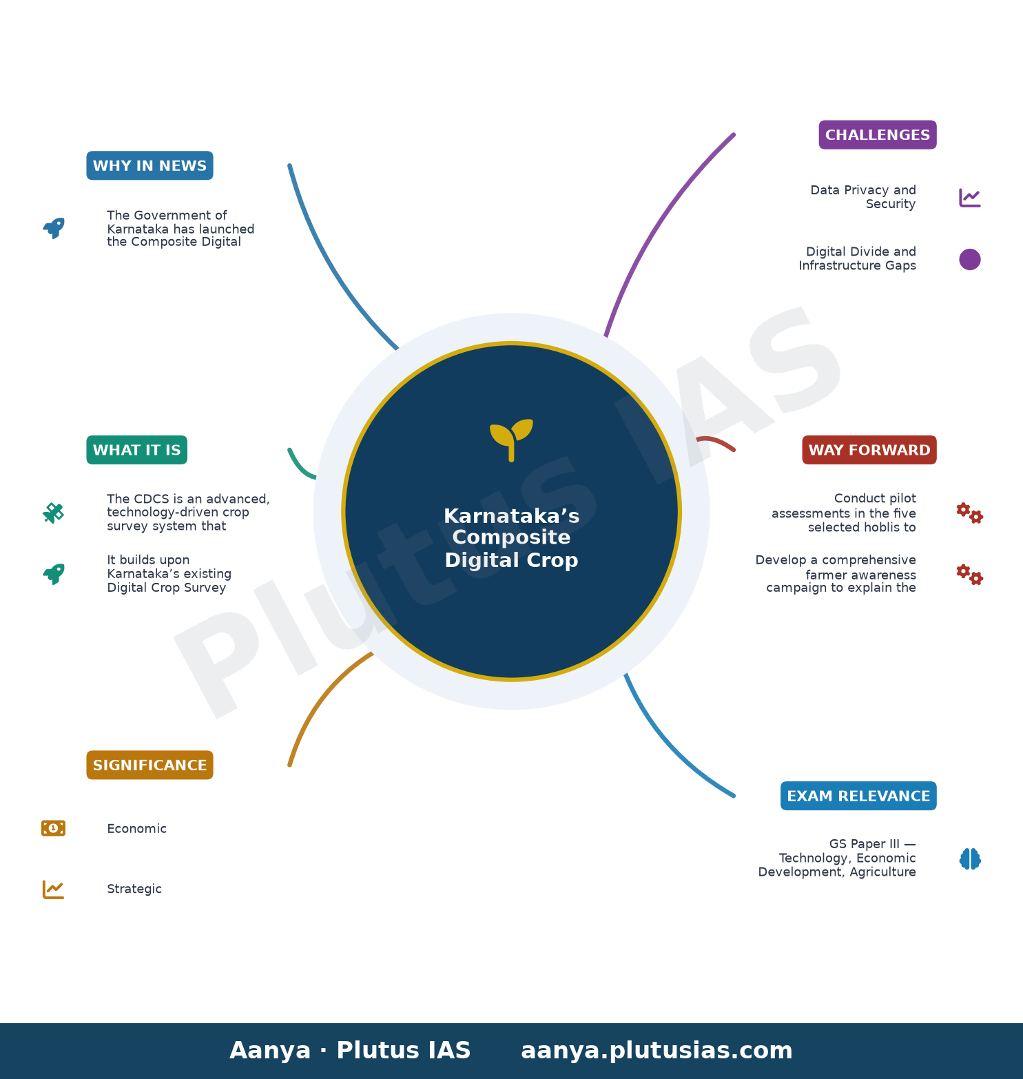
- GS Paper III — Technology, Economic Development, Agriculture
- Prelims: Digital Public Infrastructure (DPI), Remote Sensing, GIS (Geographic Information System), Synthetic Aperture Radar (SAR), Machine Learning (ML), Artificial Intelligence (AI), Crop Insurance, Agricultural Subsidies, PM-KISAN, National Mission on Sustainable Agriculture (NMSA)
- Essay: Agricultural Revolution 2.0: Merging Technology with Traditional Farming for Sustainable Development, Data-Driven Governance: The Role of AI and GIS in Transforming Public Policy
Quick Revision: The Composite Digital Crop Survey (CDCS) in Karnataka integrates AI, GIS, SAR, and drone surveys to enhance the accuracy of agricultural data, enabling evidence-based policymaking and efficient implementation of agricultural schemes.
Why is this in the news?
The Government of Karnataka has launched the Composite Digital Crop Survey (CDCS), a technologically advanced initiative that integrates high-resolution satellite imagery, Synthetic Aperture Radar (SAR), drone surveys, GIS data, Artificial Intelligence (AI), and Machine Learning (ML) to enhance the accuracy and reliability of crop data collection. This initiative, piloted in five hoblis representing Karnataka’s diverse geographical regions, builds upon the existing Digital Crop Survey (DCS) framework implemented since 2018. The CDCS aims to strengthen evidence-based policymaking, improve agricultural governance, and support schemes such as crop insurance and subsidies by providing precise, authenticated plot-level data.
Background
- Launched in 2018, Karnataka’s Digital Crop Survey (DCS) utilised a GIS-based mobile application to collect authenticated plot-level crop data, marking a significant shift from traditional manual surveys to digital data collection.
- Agricultural data collection in India has historically relied on manual methods, which are prone to errors, delays, and inconsistencies, leading to inefficiencies in policy implementation and subsidy disbursement.
- The integration of remote sensing technologies, such as high-resolution satellite imagery and SAR, enables all-weather monitoring of agricultural lands, overcoming limitations posed by cloud cover and terrain variability.
- AI and ML algorithms can process vast datasets to identify crop patterns, detect anomalies, and predict yields, thereby enhancing the precision of agricultural statistics.
- Karnataka’s initiative is part of a global trend where governments are adopting geospatial technologies to improve agricultural monitoring, reduce food insecurity, and enhance climate resilience in farming systems.
What is the Composite Digital Crop Survey (CDCS)?
- The CDCS is an advanced, technology-driven crop survey system that integrates multiple geospatial and digital tools, including high-resolution satellite imagery, SAR, drone surveys, GIS data, AI, and ML, to collect, validate, and analyse crop data at the plot level.
- It builds upon Karnataka’s existing Digital Crop Survey (DCS), which was launched in 2018 and utilised a GIS-based mobile application for data collection, but enhances it with cutting-edge technologies to improve accuracy and reliability.
- The survey is being piloted in five hoblis across Karnataka, selected to represent the state’s diverse geographical regions, including coastal, hilly, and plateau areas, ensuring comprehensive coverage and representativeness.
- High-resolution satellite imagery provides detailed visual data on land use and crop types, while SAR enables all-weather monitoring by penetrating cloud cover and detecting soil moisture and crop health.
- Drone surveys offer high-resolution, real-time data for small and fragmented landholdings, complementing satellite and SAR data to ensure no plot is left unmonitored.
- GIS integrates spatial data with administrative boundaries, enabling precise mapping and monitoring of agricultural lands, while AI and ML algorithms analyse the collected data to identify trends, detect anomalies, and predict crop yields.
- The CDCS aims to generate authenticated, plot-level crop data that can be used for evidence-based policymaking, efficient implementation of agricultural schemes, and accurate assessment of crop insurance claims and subsidy disbursements.
- By reducing manual errors and delays, the CDCS enhances the transparency and accountability of agricultural governance, ensuring that benefits reach the intended beneficiaries without leakages.
Key Features
| Feature | Significance |
|---|---|
| High-resolution satellite imagery | Enables precise identification and delineation of crop types and land parcels at a granular level, reducing manual errors in survey data. |
| Synthetic Aperture Radar (SAR) | Provides all-weather, day-night imaging capability, crucial for cloud-prone regions and accurate land-use classification. |
| Drone surveys | Facilitates high-resolution, on-demand data collection in inaccessible or small landholdings, enhancing spatial accuracy. |
| GIS integration | Allows spatial analysis, mapping, and overlay of crop data with administrative boundaries, soil types, and climatic zones. |
| Artificial Intelligence (AI) and Machine Learning (ML) | Automates crop identification, anomaly detection, and trend analysis, improving data reliability and scalability. |
Why it Matters
Economic
- Enhances agricultural productivity estimates by reducing data inaccuracies, aiding in evidence-based policy formulation for crop insurance, subsidies, and market interventions.
- Facilitates precise targeting of agricultural schemes such as the Pradhan Mantri Fasal Bima Yojana (PMFBY) and Minimum Support Price (MSP) disbursements, reducing leakages and improving fiscal efficiency.
- Supports agri-tech startups and precision farming by providing granular, real-time data on crop health, soil moisture, and yield predictions.
Strategic
- Strengthens India’s food security architecture by improving the reliability of agricultural statistics, a critical input for the National Food Security Act (NFSA) and buffer stock management.
- Enhances disaster management through early detection of crop stress (e.g., drought, pest attacks) using SAR and AI, enabling timely interventions.
- Positions Karnataka as a pioneer in digital agriculture, potentially influencing national policies on agricultural data governance and technology adoption.
Technological
- Demonstrates the integration of frontier technologies (AI, ML, GIS, drones, SAR) in governance, setting a precedent for other states and sectors.
- Reduces dependence on manual surveys, which are time-consuming, error-prone, and often biased, thereby improving data integrity.
- Enables predictive analytics for crop yield forecasting, climate-smart agriculture, and resource optimization, aligning with the Digital India vision.
Governance
- Promotes transparency and accountability in agricultural data collection, reducing corruption and rent-seeking in subsidy disbursements.
- Supports decentralised planning by providing district-level and sub-district-level data, enabling localised agricultural interventions.
- Facilitates real-time monitoring of agricultural programs, improving the efficiency of welfare schemes and reducing delays in implementation.
Environmental
- Reduces carbon footprint by minimising field visits and manual data collection, aligning with India’s climate commitments under the Paris Agreement.
- Enables precision agriculture, which optimises water, fertiliser, and pesticide use, thereby reducing environmental degradation and promoting sustainable farming.
Challenges
1. Data Privacy and Security
- Risk of unauthorised access to sensitive agricultural and landholding data, necessitating robust cybersecurity measures and compliance with data protection laws.
- Potential misuse of high-resolution imagery for land grabbing or encroachment, requiring strict regulatory safeguards.
UPSC Link: GS Paper 3: Science & Tech
2. Digital Divide and Infrastructure Gaps
- Limited digital literacy among farmers, particularly in remote and tribal regions, may hinder effective adoption of the survey system.
- Inadequate internet connectivity and power supply in rural areas could disrupt real-time data transmission and processing.
UPSC Link: GS Paper 2: Governance
3. High Initial Costs and Maintenance
- Substantial investment required for procuring satellite imagery, drones, AI/ML tools, and training personnel, posing fiscal challenges.
- Ongoing costs for software updates, data storage, and system maintenance may strain state budgets, especially for smaller districts.
UPSC Link: GS Paper 3: Economics
4. Interoperability and Standardisation
- Lack of standardised protocols for data sharing between state agencies, central ministries, and private entities may lead to fragmentation.
- Inconsistent data formats across regions could complicate national-level aggregation and analysis.
UPSC Link: GS Paper 3: Science & Tech
5. Farmer Participation and Trust
- Skepticism among farmers regarding the accuracy and fairness of AI-driven surveys may lead to resistance or non-cooperation.
- Need for extensive awareness campaigns to explain the benefits and safeguards of the system to ensure voluntary participation.
UPSC Link: GS Paper 2: Governance
6. Ethical and Bias Concerns in AI
- Risk of algorithmic bias in crop identification or yield prediction, particularly in regions with diverse cropping patterns or marginalised communities.
- Lack of transparency in AI decision-making may erode trust among stakeholders, necessitating explainable AI (XAI) frameworks.
UPSC Link: GS Paper 4: Ethics
Challenges — UPSC Perspective
| Issue | Concern |
|---|---|
| Data Privacy | Risk of unauthorised access or misuse of sensitive agricultural data. |
| Digital Divide | Limited internet and digital literacy in rural areas hindering adoption. |
| Cost and Maintenance | High initial investment and recurring expenses for technology and training. |
| Interoperability | Fragmented data systems and lack of standardised protocols. |
| Farmer Trust | Skepticism and resistance from farmers due to perceived inaccuracies or biases. |
| AI Bias | Potential algorithmic discrimination in crop identification or yield prediction. |
Government Initiatives — Must-Memorise for Prelims
- Digital Crop Survey (DCS) – Karnataka (2018)
Way Forward
- Conduct pilot assessments in the five selected hoblis to evaluate the system’s accuracy, scalability, and farmer acceptance before statewide rollout.
- Develop a comprehensive farmer awareness campaign to explain the benefits, safeguards, and participation process for the CDCS.
- Establish a multi-stakeholder governance framework involving state agencies, agricultural universities, and farmer cooperatives to oversee implementation and address grievances.
- Invest in digital infrastructure, including rural broadband expansion and last-mile connectivity, to ensure seamless data transmission.
- Formulate standardised data protocols and APIs to enable interoperability with national agricultural databases (e.g., AgriStack, Crop Insurance Portal).
- Implement robust cybersecurity measures, including encryption, access controls, and regular audits, to protect sensitive agricultural data.
- Integrate explainable AI (XAI) models to enhance transparency and reduce bias in crop identification and yield prediction algorithms.
- Explore public-private partnerships (PPPs) to leverage private sector expertise in AI/ML, drone technology, and satellite imagery while ensuring regulatory compliance.
UPSC Value Addition
Keywords for Mains Answer-Writing
Digital Public Infrastructure · Agricultural Data Governance · Artificial Intelligence in Governance · Synthetic Aperture Radar (SAR) · Geographic Information Systems (GIS) · Drone-based Surveys · Evidence-based Policymaking · Composite Digital Crop Survey (CDCS) · Precision Agriculture · Data-Driven Governance · Machine Learning in Administration · Karnataka Agricultural Policy · High-Resolution Satellite Imagery · Sustainable Agriculture
Concept Flow
Agricultural Data Inaccuracy → Manual Surveys → High Error Rates → Policy Inefficiencies → Need for Technological Intervention → Manual Surveys → Time-Consuming and Costly → Limited Coverage → Incomplete Data → Poor Targeting of Welfare Schemes → Emergence of Digital Agriculture → Government of Karnataka → Development of Digital Crop Survey (DCS) in 2018 → Integration of AI, ML, GIS, SAR, and Drones → AI/ML Integration → Automated Crop Identification → High-Resolution Satellite and Drone Imagery → Real-Time Data Collection → Enhanced Accuracy → Accurate Crop Data → Evidence-Based Policymaking → Targeted Subsidies and Insurance (e.g., PMFBY) → Improved Agricultural Productivity → Digital Infrastructure → Farmer Awareness and Participation → Trust in System → Sustainable Adoption → Scalability Across States → Policy Feedback Loop → Continuous Improvement → National-Level Integration → Strengthening of India’s Agricultural Data Ecosystem
Prelims Practice Questions
Q1. Consider the following statements regarding the Composite Digital Crop Survey (CDCS) launched by Karnataka:
1. It integrates Artificial Intelligence and Machine Learning for crop data validation.
2. The survey utilises Synthetic Aperture Radar (SAR) and drone surveys for data collection.
3. The CDCS is implemented across all districts of Karnataka without any pilot phase.
How many of the above statements are correct?
- Only one
- Only two
- All three
- None
Answer: Only two — Statements 1 and 2 are correct as the CDCS integrates AI/ML and uses SAR and drone surveys. Statement 3 is incorrect because the survey is implemented on a pilot basis in five selected hoblis.
Q2. Assertion (A): The Composite Digital Crop Survey (CDCS) aims to increase the accuracy of agricultural data through high-resolution satellite imagery and GIS.
Reason (R): The CDCS replaces the existing Digital Crop Survey (DCS) entirely, discontinuing its GIS-based mobile app.
In the context of the above statements, which of the following is correct?
- Both A and R are true, and R is the correct explanation of A.
- Both A and R are true, but R is not the correct explanation of A.
- A is true, but R is false.
- A is false, but R is true.
Answer: A is true, but R is false. — Assertion (A) is true as the CDCS enhances accuracy using satellite imagery and GIS. Reason (R) is false because the CDCS builds upon the existing DCS rather than replacing it entirely.
Q3. Which of the following technologies is NOT being integrated into Karnataka’s Composite Digital Crop Survey (CDCS)?
- Blockchain for data security
- Artificial Intelligence for data analysis
- Synthetic Aperture Radar (SAR) for crop monitoring
- Drone surveys for high-resolution data collection
Answer: Blockchain for data security — Blockchain is not mentioned in the CDCS framework. The survey integrates AI, SAR, and drone surveys for data collection and analysis.
Mains Practice Question
✍ Critically examine the role of Digital Public Infrastructure (DPI) in transforming agricultural governance in India. How does Karnataka’s Composite Digital Crop Survey (CDCS) exemplify this transformation? (15 Marks)
Approach: MODEL-ANSWER SKELETON:
1. **Conceptual Framework of DPI in Agriculture** (40 words):
– Define DPI: digital systems enabling efficient, inclusive, and secure delivery of public services (e.g., Aadhaar, UPI, DigiLocker).
– Link to agriculture: precision farming, data-driven policies, and farmer welfare.
2. **Karnataka’s CDCS: Technological Integration** (50 words):
– Highlight core technologies: AI/ML, SAR, drone surveys, GIS, and satellite imagery.
– Explain how these enhance accuracy, reduce manual errors, and enable real-time monitoring.
– Contrast with the earlier GIS-based Digital Crop Survey (DCS) since 2018.
3. **Evidence-Based Policymaking** (30 words):
– Discuss how CDCS supports targeted interventions (e.g., subsidies, insurance, crop diversification).
– Cite the role of Principal Secretary Pankaj Kumar Pandey in emphasizing evidence-based governance.
4. **Challenges and Limitations** (30 words):
– Data privacy concerns, digital divide, and infrastructure gaps in rural areas.
– Highlight the pilot phase in five hoblis to address scalability issues.
5. **Broader Implications for India** (40 words):
– Potential for replication across states (e.g., Odisha’s Bhu-Naksha, Maharashtra’s MahaAgriTech).
– Role in achieving Sustainable Development Goals (SDG 2: Zero Hunger) and climate-resilient agriculture.
6. **Conclusion** (20 words):
– Summarize CDCS as a model for DPI in agriculture, balancing innovation with inclusivity.
Source: The Hindu
Generated by AanyaAi for educational purpose.

- कर्नाटक हाईकोर्ट ने KPSC घोटाले की जांच के लिए डीजीपी अलोक कुमार की अध्यक्षता में SIT गठित की - September 21, 2026
- Karnataka HC forms SIT to probe KPSC recruitment scam: Key facts for UPSC - September 21, 2026
- यूपीएससी के लिए सीएसआईआर साइक्विज: जानिए कैसे करें भागीदारी और लाभ उठाएं - September 21, 2026

No Comments