


06 Aug Karnataka Launches AI-Powered Digital Crop Survey for UPSC 2026
✎ The Composite Digital Crop Survey (CDCS) in Karnataka integrates high-resolution satellite imagery, SAR, drones, GIS, AI, and ML to enhance the accuracy and reliability of agricultural data, building upon the existing Digital…
Subject Relevance — Where This Topic Fits
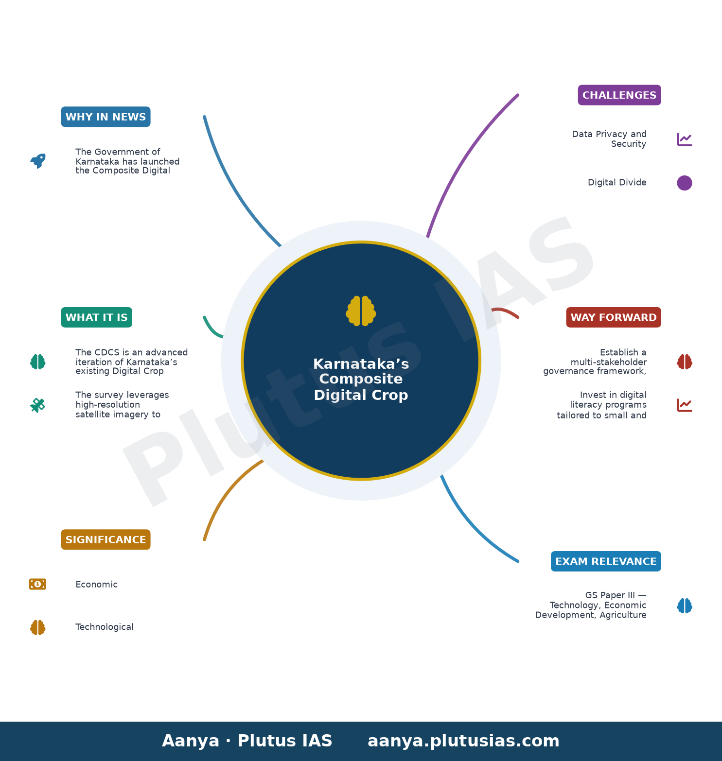
- GS Paper III — Technology, Economic Development, Agriculture
- Prelims: Digital Public Infrastructure (DPI), Geospatial technologies, Remote Sensing, Machine Learning, Synthetic Aperture Radar (SAR), GIS-based mobile applications, Agricultural census, Precision agriculture
- Essay: The convergence of technology and governance in sustainable agricultural development
Quick Revision: The Composite Digital Crop Survey (CDCS) in Karnataka integrates high-resolution satellite imagery, SAR, drones, GIS, AI, and ML to enhance the accuracy and reliability of agricultural data, building upon the existing Digital Crop Survey (DCS) framework introduced in 2018.
Why is this in the news?
The Government of Karnataka has launched the Composite Digital Crop Survey (CDCS), a pilot initiative integrating high-resolution satellite imagery, Synthetic Aperture Radar (SAR), drone surveys, GIS data, and Artificial Intelligence (AI) with Machine Learning (ML) to enhance the accuracy, reliability, and scientific validation of crop data. This initiative builds upon the existing Digital Crop Survey (DCS) framework, which has been operational since 2018, and marks a significant technological advancement in agricultural data governance and evidence-based policymaking.
Background
- The Digital Crop Survey (DCS) was introduced in Karnataka in 2018 as a GIS-based mobile application to collect authenticated plot-level crop data, replacing traditional paper-based surveys.
- The DCS aimed to address challenges such as data inaccuracies, delays in data collection, and lack of real-time information in agricultural statistics.
- Karnataka’s agricultural sector contributes significantly to the state’s economy, with a diverse range of crops cultivated across varied agro-climatic zones.
- The integration of emerging technologies in agricultural data collection aligns with the broader national agenda of leveraging digital public infrastructure (DPI) for governance and development.
- The pilot phase of the CDCS will be implemented in five selected hoblis to ensure geographical representation across the state.
- The initiative is part of Karnataka’s broader strategy to enhance agricultural productivity, sustainability, and resilience through data-driven governance.
What is the Composite Digital Crop Survey (CDCS)?
- The CDCS is an advanced iteration of Karnataka’s existing Digital Crop Survey (DCS), designed to enhance the accuracy, reliability, and scientific validation of crop data through the integration of cutting-edge technologies.
- The survey leverages high-resolution satellite imagery to capture detailed land-use patterns and crop types with precision.
- Synthetic Aperture Radar (SAR) technology is employed to penetrate cloud cover and provide consistent data, particularly useful during monsoon seasons.
- Drone surveys complement satellite data by offering high-resolution, localized imagery for smallholder plots and heterogeneous landscapes.
- Geographic Information Systems (GIS) serve as the backbone for spatial data analysis, enabling the mapping and monitoring of agricultural activities across the state.
- Artificial Intelligence (AI) and Machine Learning (ML) algorithms are applied to process vast datasets, identify crop patterns, detect anomalies, and predict agricultural trends.
- The pilot phase will be conducted in five hoblis, selected to represent Karnataka’s diverse geographical divisions, ensuring comprehensive coverage and validation of the model.
- The CDCS aims to support evidence-based policymaking by providing real-time, accurate, and granular agricultural data to stakeholders, including farmers, researchers, and government agencies.
Key Features
| Feature | Significance |
|---|---|
| High-resolution satellite imagery | Enables precise, large-scale monitoring of crop health, land use, and vegetation indices, reducing manual errors in crop classification. |
| Synthetic Aperture Radar (SAR) | Provides all-weather, day-night imaging capability, crucial for cloud-prone regions, and detects soil moisture and crop density with high accuracy. |
| Drone surveys | Facilitates hyper-local, real-time data collection in inaccessible or smallholder-dominated agricultural landscapes, enhancing granularity of survey data. |
| Geographic Information System (GIS) integration | Spatial mapping of agricultural plots with administrative boundaries, enabling evidence-based spatial planning and resource allocation. |
| Artificial Intelligence (AI) and Machine Learning (ML) | Automates crop identification, yield estimation, and anomaly detection, while continuously improving accuracy through iterative learning from historical and real-time data. |
Why it Matters
Economic
- Enhances agricultural productivity estimates by reducing data inaccuracies, thereby improving crop insurance payouts, loan disbursals, and market linkages for farmers.
- Supports evidence-based agricultural policies, including input subsidies, price stabilization, and export promotion, by providing reliable, granular crop data.
- Reduces transaction costs in agricultural supply chains by streamlining data verification processes for traders, processors, and agri-tech firms.
Technological
- Demonstrates Karnataka’s leadership in leveraging Fourth Industrial Revolution technologies (AI, ML, IoT) for governance, setting a precedent for other states.
- Creates a scalable model for integrating multi-source geospatial data (satellite, drone, SAR) with AI/ML for real-time agricultural monitoring.
- Facilitates the development of a digital twin of Karnataka’s agricultural landscape, enabling predictive analytics for climate-resilient farming.
Governance
- Strengthens the credibility of agricultural statistics by reducing human bias and manual errors in crop surveys, aligning with global best practices.
- Enhances transparency in subsidy disbursement and welfare schemes by providing verifiable, tamper-proof data on land use and crop patterns.
- Supports decentralized planning by empowering local governments (panchayats, hoblis) with high-resolution, actionable agricultural data.
Environmental
- Enables precise monitoring of land degradation, water stress, and deforestation linked to agricultural expansion, aiding sustainable land-use planning.
- Supports climate-smart agriculture by providing data on crop resilience, soil health, and water usage, critical for adaptation strategies.
Challenges
1. Data Privacy and Security
- Risk of misuse of high-resolution farm-level data by private entities or unauthorized actors, necessitating robust data governance frameworks.
- Potential for surveillance concerns if agricultural data is linked with farmer identities without explicit consent mechanisms.
UPSC Link: GS-II: Data Governance
2. Digital Divide
- Limited digital literacy among small and marginal farmers may hinder effective adoption of AI-driven survey tools and data interpretation.
- Unequal access to smartphones, internet connectivity, and technical support in remote or tribal agricultural regions.
UPSC Link: GS-II: Digital Divide
3. Technological Dependence
- Vulnerability to system failures, cyberattacks, or algorithmic biases in AI/ML models, which could distort crop estimates and policy decisions.
- High initial investment and maintenance costs for advanced technologies like SAR, drones, and AI infrastructure.
UPSC Link: GS-III: Technology and Development
4. Interoperability and Standardization
- Challenges in integrating diverse data sources (satellite, drone, SAR) with existing agricultural databases due to lack of standardized protocols.
- Need for harmonized metadata standards to ensure consistency across multi-temporal and multi-scalar datasets.
UPSC Link: GS-II: E-Governance
5. Farmer Participation and Trust
- Risk of farmer skepticism toward AI-driven surveys, particularly if historical data inaccuracies persist or if benefits are not clearly communicated.
- Resistance to adoption due to perceived complexity or lack of visible short-term incentives for participation.
UPSC Link: GS-I: Farmer Welfare
Challenges — UPSC Perspective
| Issue | Concern |
|---|---|
| Data Privacy | Risk of unauthorized access or commercial exploitation of sensitive farm-level data. |
| Digital Literacy | Low adoption rates among smallholders due to lack of technical skills and infrastructure. |
| Cost and Scalability | High capital expenditure and recurring maintenance costs for AI/SAR/drone infrastructure. |
| Algorithmic Bias | Potential inaccuracies in AI/ML models due to unrepresentative training datasets or regional variations. |
| Interoperability Gaps | Difficulty in integrating heterogeneous data sources (e.g., satellite vs. drone imagery) into a unified system. |
| Farmer Trust Deficit | Skepticism toward AI-driven surveys if past inaccuracies or lack of transparency persist. |
Way Forward
- Establish a multi-stakeholder governance framework, including farmers, technologists, and policymakers, to co-design data privacy protocols and consent mechanisms.
- Invest in digital literacy programs tailored to small and marginal farmers, focusing on mobile app usage, data interpretation, and cybersecurity awareness.
- Develop a phased rollout strategy with pilot evaluations in diverse agro-climatic zones to assess technological feasibility and cost-effectiveness.
- Create a centralized data repository with open APIs for researchers, agri-tech firms, and government agencies, ensuring interoperability and standardized metadata.
- Implement real-time monitoring and feedback loops for AI/ML models to continuously improve accuracy and address regional biases in crop classification.
- Strengthen cybersecurity infrastructure to protect farm-level data from breaches, while ensuring compliance with the Digital Personal Data Protection Act, 2023.
- Integrate the CDCS with existing agricultural schemes (e.g., PM-KISAN, PMFBY) to enhance targeting efficiency and reduce leakages in subsidy disbursements.
- Conduct periodic farmer awareness campaigns to build trust, demonstrate tangible benefits (e.g., faster insurance claims, better loan access), and solicit feedback for iterative improvements.
UPSC Value Addition
Keywords for Mains Answer-Writing
Digital Crop Survey (DCS) · Composite Digital Crop Survey (CDCS) · Artificial Intelligence in agriculture · Machine Learning for crop data · GIS-based agricultural survey · High-resolution satellite imagery in agriculture · Synthetic Aperture Radar (SAR) in crop monitoring · Drone surveys for agricultural data · Evidence-based agricultural policymaking · Precision agriculture technologies · Karnataka agricultural reforms · Agricultural data accuracy and reliability · Digital governance in rural India
Concept Flow
Agricultural Data Inaccuracy → Karnataka’s Digital Crop Survey (DCS) since 2018 → Limitations in GIS-based manual data collection → Need for higher accuracy → Development of Composite Digital Crop Survey (CDCS) → CDCS integrates AI, ML, SAR, drones, and satellite imagery → Enhances precision in crop identification and yield estimation → Provides granular, real-time data → Granular data enables evidence-based policymaking → Supports subsidy targeting, insurance payouts, and climate-resilient agriculture → Strengthens agricultural governance → High-resolution data raises concerns over privacy and digital divide → Requires robust data governance and digital literacy initiatives → Ensures equitable and secure adoption → Successful implementation in Karnataka → Potential replication across states → Contributes to India’s digital agriculture ecosystem and global agricultural data standards
Prelims Practice Questions
Q1. Consider the following statements regarding the Digital Crop Survey (DCS) in Karnataka:
1. The DCS was launched in 2018 using a GIS-based mobile app.
2. The Composite Digital Crop Survey (CDCS) integrates Artificial Intelligence and Machine Learning.
3. The CDCS uses Synthetic Aperture Radar (SAR) and drone surveys for data collection.
4. The CDCS is implemented across all hoblis in Karnataka without any pilot basis.
How many of the above statements are correct?
- Only one
- Only two
- Only three
- All
Answer: Only three — Statements 1, 2, and 3 are correct. Statement 4 is incorrect as the CDCS is being implemented on a pilot basis in five selected hoblis.
Q2. Assertion (A): The Composite Digital Crop Survey (CDCS) in Karnataka aims to enhance the accuracy and reliability of agricultural data.
Reason (R): The CDCS integrates high-resolution satellite imagery, Synthetic Aperture Radar (SAR), drone surveys, GIS data, Artificial Intelligence, and Machine Learning.
Options:
A. Both A and R are true, and R is the correct explanation of A.
B. Both A and R are true, but R is not the correct explanation of A.
C. A is true, but R is false.
D. A is false, but R is true.
- A
- B
- C
- D
Answer: A — Both A and R are true, and R correctly explains A, as the integration of advanced technologies directly aims to improve data accuracy and reliability.
Q3. Match the following technologies with their applications in the Composite Digital Crop Survey (CDCS):
Technologies:
1. High-resolution satellite imagery
2. Synthetic Aperture Radar (SAR)
3. Drone surveys
4. GIS data
Applications:
a. Provides real-time, high-precision visual data of crop fields
b. Captures data in all weather conditions, including cloud cover
c. Enables spatial analysis and mapping of agricultural plots
d. Facilitates ground-level verification and small-scale data collection
Options:
A. 1-a, 2-b, 3-d, 4-c
B. 1-b, 2-a, 3-c, 4-d
C. 1-c, 2-d, 3-a, 4-b
D. 1-d, 2-c, 3-b, 4-a
- A
- B
- C
- D
Answer: A — The correct matches are: 1-a (High-resolution satellite imagery provides real-time visual data), 2-b (SAR captures data in all weather conditions), 3-d (Drones facilitate ground-level verification), and 4-c (GIS enables spatial analysis).
Mains Practice Question
✍ Critically analyse the role of the Composite Digital Crop Survey (CDCS) in transforming agricultural governance in Karnataka. How does the integration of AI, ML, GIS, and drone technologies address the challenges of data accuracy and evidence-based policymaking? Also, discuss the potential limitations and ethical concerns associated with such digital interventions in agriculture. (15 Marks)
Approach: MODEL-ANSWER SKELETON:
1. **Introduction (2 Marks)**
– Briefly define the Digital Crop Survey (DCS) and its evolution into the Composite Digital Crop Survey (CDCS).
– Highlight the significance of accurate agricultural data for evidence-based policymaking and agricultural reforms.
2. **Technological Integration and Its Benefits (5 Marks)**
– **AI and ML**: Explain how AI and ML algorithms enhance data processing, pattern recognition, and predictive analytics for crop yield estimation and pest detection.
– **GIS**: Discuss the role of GIS in spatial mapping, land-use planning, and resource allocation.
– **High-resolution satellite imagery and SAR**: Describe their utility in monitoring large agricultural areas, detecting crop health, and overcoming weather-related data collection challenges.
– **Drone surveys**: Explain their role in ground-level verification, small-scale data collection, and real-time monitoring.
– **Evidence-based policymaking**: Discuss how these technologies enable data-driven decisions for agricultural subsidies, crop insurance, and resource allocation.
3. **Challenges and Limitations (5 Marks)**
– **Data accuracy and reliability**: Discuss potential errors in satellite imagery, SAR, and drone data, including issues of resolution, calibration, and interpretation.
– **Digital divide**: Highlight the disparity in access to technology between large and small farmers, and rural-urban divides.
– **Privacy and ethical concerns**: Address issues of data ownership, consent, and potential misuse of agricultural data by private entities or government agencies.
– **Cost and scalability**: Discuss the financial and logistical challenges of implementing such technologies across diverse geographical regions.
4. **Conclusion and Way Forward (3 Marks)**
– Summarise the transformative potential of CDCS in agricultural governance.
– Suggest measures to address limitations, such as capacity building, public-private partnerships, and regulatory frameworks for data governance.
– Emphasise the need for inclusive and ethical deployment of digital technologies in agriculture.
Source: The Hindu
Generated by AanyaAi for educational purpose.

- यूपी नीट यूजी काउंसलिंग राउंड-2: मेरिट लिस्ट हुई जारी, 22 सितंबर से रिपोर्टिंग शुरू - September 21, 2026
- UP NEET UG Counselling 2026 Round 2: Merit List Out, Key Dates & Reporting Process - September 21, 2026
- UPSC Civil Services (Main) Examination 2026 — Geology Optional Paper I: Question Paper | Plutus IAS - September 21, 2026

No Comments