


09 Aug Karnataka’s AI-Powered Digital Crop Survey: Boosting Agricultural Governance for UPSC
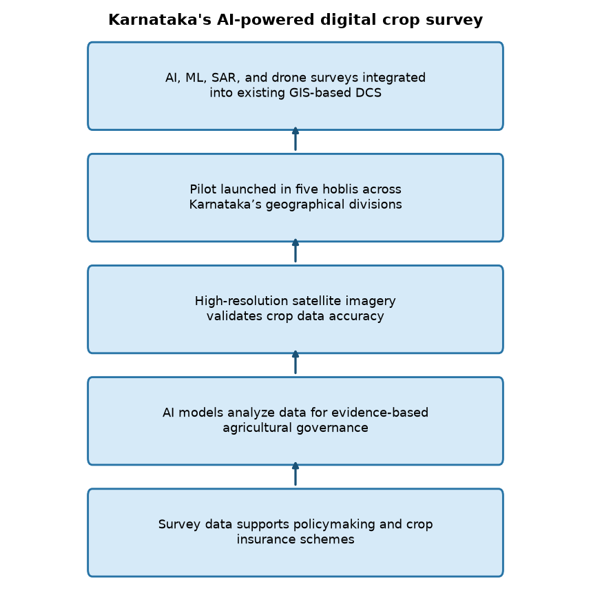
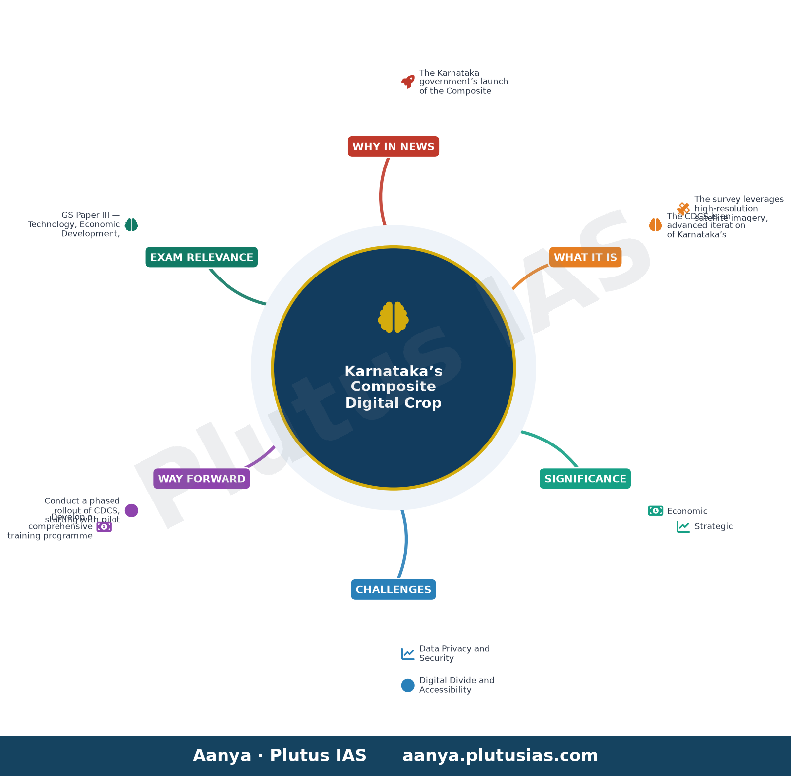
✎ Karnataka’s Composite Digital Crop Survey integrates AI, ML, SAR, and drone surveys with GIS to enhance the accuracy of plot-level agricultural data, building on the Digital Crop Survey (DCS) framework introduced in 2018.
Subject Relevance — Where This Topic Fits
- GS Paper III — Technology, Economic Development, Agriculture
- Prelims: Digital Public Infrastructure, Precision Agriculture, Geospatial Data, AI in Governance, Crop Insurance Schemes, Pradhan Mantri Fasal Bima Yojana, National Mission on Sustainable Agriculture, Remote Sensing
- Essay: The Role of Technology in Transforming India’s Agricultural Sector, Data-Driven Governance: Balancing Innovation and Inclusion
Quick Revision: Karnataka’s Composite Digital Crop Survey integrates AI, ML, SAR, and drone surveys with GIS to enhance the accuracy of plot-level agricultural data, building on the Digital Crop Survey (DCS) framework introduced in 2018.
Why is this in the news?
The Karnataka government’s launch of the Composite Digital Crop Survey (CDCS) marks a significant evolution in India’s agricultural data collection systems, integrating advanced technologies such as Artificial Intelligence (AI), Machine Learning (ML), Synthetic Aperture Radar (SAR), and drone surveys to enhance the accuracy and reliability of crop data. This initiative is particularly noteworthy as it builds upon the existing Digital Crop Survey (DCS) framework, which has been operational since 2018, and aims to address longstanding challenges in agricultural governance, including data authenticity, policy formulation, and evidence-based decision-making.
Background
- The Digital Crop Survey (DCS) was introduced by Karnataka in 2018 as a GIS-based mobile application to collect authenticated plot-level crop data, replacing traditional manual surveys that were prone to errors and delays.
- Agricultural data collection in India has historically relied on manual methods, which are susceptible to inaccuracies due to human error, incomplete coverage, and delayed reporting, leading to inefficiencies in policy implementation and subsidy distribution.
- The integration of geospatial technologies, including satellite imagery and GIS, has been progressively adopted in India’s agricultural sector to improve data precision, with initiatives such as the National Remote Sensing Centre (NRSC) providing satellite-based crop monitoring.
- Karnataka’s CDCS aligns with the broader national agenda of leveraging technology for agricultural transformation, as outlined in schemes like the Pradhan Mantri Fasal Bima Yojana (PMFBY) and the National Mission on Sustainable Agriculture (NMSA), which emphasize data-driven decision-making.
- The use of AI and ML in agriculture is gaining traction globally, with applications ranging from crop yield prediction to pest detection, and Karnataka’s initiative represents a localized adaptation of these technologies for governance purposes.
- The pilot phase of the CDCS will be implemented in five selected hoblis across Karnataka, ensuring geographical representation and allowing for iterative refinement before statewide adoption.
What is Karnataka’s Composite Digital Crop Survey (CDCS)?
- The CDCS is an advanced iteration of Karnataka’s existing Digital Crop Survey (DCS), designed to enhance the accuracy, reliability, and scientific validation of crop data through the integration of cutting-edge technologies.
- The survey leverages high-resolution satellite imagery, Synthetic Aperture Radar (SAR), drone surveys, and GIS data to capture real-time, plot-level agricultural information with minimal human intervention.
- Artificial Intelligence (AI) and Machine Learning (ML) algorithms are employed to process and analyze the vast datasets generated from these technologies, enabling predictive analytics and automated data validation.
- The CDCS aims to address critical gaps in traditional agricultural data collection, such as underreporting, overestimation, and delays in reporting, which have historically hindered effective policymaking and subsidy distribution.
- By providing authenticated and granular crop data, the CDCS will support evidence-based governance, improve the targeting of agricultural subsidies and insurance schemes, and enhance the efficiency of resource allocation.
- The pilot phase, covering five hoblis, will serve as a testbed for the technology’s scalability and effectiveness, with lessons learned informing a potential statewide rollout.
- The initiative is aligned with Karnataka’s broader digital governance strategy, which emphasizes the use of technology to improve public service delivery and administrative efficiency.
- The CDCS also has implications for climate-resilient agriculture, as accurate crop data can inform adaptation strategies in the face of changing weather patterns and extreme events.
Key Features
| Feature | Significance |
|---|---|
| High-resolution satellite imagery | Enables precise, real-time monitoring of agricultural land use and crop health across vast areas, reducing manual survey errors. |
| Synthetic Aperture Radar (SAR) | Provides cloud-penetrating imaging, critical for consistent data collection during monsoon seasons and night-time operations. |
| Drone surveys | Facilitates hyper-localised, high-accuracy data collection in inaccessible or small-plot terrains, complementing satellite data. |
| GIS integration | Allows spatial analysis and mapping of crop patterns, soil types, and agro-climatic zones for targeted agricultural interventions. |
| Artificial Intelligence (AI) and Machine Learning (ML) | Automates data validation, anomaly detection, and predictive modelling to enhance the reliability of crop estimates and policy inputs. |
Why it Matters
Economic
- Enhances the accuracy of agricultural statistics, reducing information asymmetry in commodity markets and improving price discovery mechanisms.
- Supports evidence-based policy formulation for crop insurance schemes (e.g., PMFBY), fertiliser subsidies, and Minimum Support Price (MSP) decisions.
- Facilitates precision agriculture, enabling farmers to optimise input use (seeds, fertilisers, water) and reduce cost of cultivation.
Strategic
- Strengthens India’s food security by improving the reliability of crop production estimates, aiding stockpile management and buffer stock policies.
- Enhances India’s position in global agricultural trade negotiations by providing verifiable, high-frequency crop data to trading partners.
- Reduces dependence on manual surveys, which are prone to delays, human errors, and political interference.
Technological
- Demonstrates the integration of frontier technologies (AI, ML, SAR, drones) in governance, setting a precedent for other states and sectors.
- Promotes interoperability between geospatial data systems, fostering innovation in agri-tech startups and research institutions.
- Provides a scalable model for digital public infrastructure in rural India, bridging the urban-rural digital divide.
Administrative
- Improves the efficiency of land records management by linking crop data with existing revenue records (e.g., Bhulekh in Karnataka).
- Enables real-time monitoring of crop health, allowing early detection of pest attacks or drought conditions for timely interventions.
- Reduces bureaucratic delays in disbursing agricultural benefits by automating data verification and eligibility checks.
Environmental
- Supports sustainable agriculture by enabling data-driven decisions on crop rotation, water conservation, and climate-resilient practices.
- Reduces the carbon footprint of traditional survey methods (e.g., paper-based records, vehicle-based field visits).
- Facilitates monitoring of agricultural practices contributing to soil degradation or water stress, aiding in targeted remediation.
Challenges
1. Data Privacy and Security
- Risk of unauthorised access or misuse of high-resolution geospatial and personal farm data, necessitating robust cybersecurity frameworks.
- Compliance with the Digital Personal Data Protection Act, 2023, for handling farmer-specific data collected during surveys.
UPSC Link: GS3: Cyber Security
2. Digital Divide and Accessibility
- Unequal access to digital tools among farmers, particularly smallholders and marginalised communities, may lead to exclusion or misrepresentation.
- Dependence on smartphones and internet connectivity in remote rural areas poses operational challenges.
UPSC Link: GS1: Rural Development
3. Technological Adoption and Capacity Building
- Resistance from field staff accustomed to traditional survey methods, requiring extensive training and change management.
- High initial costs of procuring drones, SAR equipment, and AI/ML models may strain state budgets.
UPSC Link: GS2: Governance
4. Accuracy and Validation of AI/ML Models
- Risk of algorithmic bias or errors in AI/ML models, particularly in diverse agro-climatic zones of Karnataka.
- Need for continuous validation against ground-truth data to ensure reliability of automated crop classification.
UPSC Link: GS3: Science & Technology
5. Interoperability with Existing Systems
- Challenges in integrating CDCS with existing digital platforms (e.g., PM-KISAN, Soil Health Card) due to incompatible data formats.
- Ensuring seamless data flow between central and state agencies for national-level agricultural planning.
UPSC Link: GS2: Federalism
Challenges — UPSC Perspective
| Issue | Concern |
|---|---|
| High-resolution data storage | Exponential storage requirements for satellite imagery, drone footage, and AI-generated outputs. |
| Farmer consent and awareness | Lack of understanding among farmers about data usage, leading to resistance or misinformation. |
| Regulatory compliance | Navigating multiple data protection laws (e.g., DPDP Act, 2023) and agricultural data policies. |
| Scalability constraints | Limited availability of skilled personnel and infrastructure to scale CDCS across all districts. |
| Ethical considerations | Potential misuse of crop data for speculative trading or monopolistic practices in agri-input industries. |
Way Forward
- Conduct a phased rollout of CDCS, starting with pilot districts, and expand based on lessons learned from the pilot phase.
- Develop a comprehensive training programme for field staff, revenue officials, and farmers to ensure smooth adoption of digital tools.
- Establish a multi-stakeholder governance framework, including farmers’ representatives, to oversee data privacy, security, and ethical use.
- Invest in public-private partnerships to leverage expertise in AI/ML, geospatial analytics, and drone technology for cost-effective implementation.
- Integrate CDCS with national agricultural databases (e.g., AgriStack, Soil Health Card) to ensure interoperability and avoid duplication.
- Promote open-data policies for non-sensitive agricultural data to foster innovation in agri-tech startups and research institutions.
- Strengthen cybersecurity infrastructure to protect against data breaches and unauthorised access to sensitive farm data.
- Monitor and evaluate the impact of CDCS on agricultural productivity, farmer incomes, and policy outcomes through regular audits.
UPSC Value Addition
Keywords for Mains Answer-Writing
Digital Public Infrastructure in Agriculture · Composite Digital Crop Survey (CDCS) · Artificial Intelligence in agriculture · Synthetic Aperture Radar (SAR) · Drone-based crop survey · GIS-enabled agricultural data · Evidence-based policymaking in agriculture · Precision agriculture technologies · Karnataka’s agricultural modernisation · Data-driven governance in rural India
Concept Flow
Agricultural data gaps in traditional surveys lead to inaccuracies in crop estimates and policy decisions. → Government of Karnataka initiates Digital Crop Survey (DCS) in 2018 to digitise plot-level crop data using GIS-based mobile apps. → Limited accuracy and scalability of DCS necessitate integration of advanced technologies (AI, ML, SAR, drones). → Composite Digital Crop Survey (CDCS) is launched, combining high-resolution satellite imagery, SAR, drone surveys, and AI/ML. → CDCS enables real-time, hyper-localised, and automated crop monitoring, improving data reliability and policy relevance. → Accurate agricultural data supports evidence-based governance, food security, and sustainable agricultural practices. → Scalable model demonstrates the potential for national adoption, aligning with India’s digital public infrastructure goals.
Prelims Practice Questions
Q1. Consider the following statements regarding Karnataka’s Composite Digital Crop Survey (CDCS):
1. It integrates high-resolution satellite imagery, Synthetic Aperture Radar (SAR), and drone surveys.
2. The survey is being piloted in five selected hoblis representing all geographical divisions of Karnataka.
3. The CDCS replaces the Digital Crop Survey (DCS) launched in 2018.
4. Artificial Intelligence and Machine Learning are used to enhance the accuracy of agricultural data.
How many of the above statements are correct?
- Only one
- Only two
- Only three
- All
Answer: Only three — Statements 1, 2, and 4 are correct. Statement 3 is incorrect as the CDCS enhances the existing DCS framework rather than replacing it.
Q2. Assertion (A): The Composite Digital Crop Survey (CDCS) in Karnataka utilises Synthetic Aperture Radar (SAR) to improve the accuracy of crop data.
Reason (R): SAR can penetrate cloud cover and provide high-resolution data, making it ideal for agricultural surveys in monsoon-dependent regions.
In the context of the above statements, which of the following is correct?
- Both A and R are true, and R is the correct explanation of A.
- Both A and R are true, but R is NOT the correct explanation of A.
- A is true, but R is false.
- A is false, but R is true.
Answer: Both A and R are true, and R is the correct explanation of A. — Both the assertion and reason are true, and the reason correctly explains the assertion. SAR’s ability to penetrate cloud cover and provide high-resolution data makes it particularly useful for agricultural surveys in regions like Karnataka.
Q3. Which of the following technologies is NOT directly integrated into Karnataka’s Composite Digital Crop Survey (CDCS)?
- A. High-resolution satellite imagery
- B. Blockchain for land records
- C. Synthetic Aperture Radar (SAR)
- D. Drone surveys
Answer: B. Blockchain for land records — Blockchain for land records is not mentioned as part of the CDCS. The survey integrates high-resolution satellite imagery, SAR, drone surveys, GIS data, AI, and ML.
Mains Practice Question
✍ The Composite Digital Crop Survey (CDCS) in Karnataka represents a paradigm shift in agricultural data collection through the integration of advanced technologies. Critically examine the potential of CDCS to enhance evidence-based policymaking in agriculture. Also, discuss the challenges in scaling such digital public infrastructure in rural India. (15 Marks)
Approach: MODEL-ANSWER SKELETON:
1. **Introduction**: Define CDCS and its technological components (high-resolution satellite imagery, SAR, drones, GIS, AI/ML). Contextualise its launch in Karnataka as a pilot in five hoblis.
2. **Potential for Evidence-Based Policymaking**:
– **Accuracy and Reliability**: AI/ML and SAR improve data precision, reducing human errors in traditional surveys.
– **Real-Time Monitoring**: Satellite and drone data enable dynamic crop monitoring, aiding in drought/flood response and crop insurance schemes.
– **Policy Formulation**: GIS-enabled data supports targeted subsidies, soil health mapping, and climate-resilient agriculture.
– **Transparency**: Digital records reduce corruption in subsidy distribution and land records.
3. **Challenges in Scaling Digital Public Infrastructure**:
– **Digital Divide**: Rural India faces connectivity gaps, lack of smartphones, and digital literacy issues.
– **Data Privacy**: Concerns over ownership and misuse of agricultural data (e.g., corporate exploitation).
– **Cost and Maintenance**: High initial investment in technology and training for state agencies.
– **Interoperability**: Integration with existing land records (e.g., Bhulekh) and other databases (e.g., PM-KISAN).
– **Ethical Considerations**: Bias in AI models if trained on non-representative data.
4. **Comparative Perspective**: Reference India’s broader digital public infrastructure (e.g., PM-KISAN, Soil Health Cards) and global examples (e.g., Brazil’s agricultural data systems).
5. **Conclusion**: Balance the transformative potential of CDCS with the need for inclusive, equitable, and sustainable scaling.
Source: The Hindu
Generated by AanyaAi for educational purpose.

- बिहार सरकार का बड़ा कदम: 25 हजार परिवारों को सौर ऊर्जा सहायता, 534 प्रखंडों में सोलर मार्ट खोले जाएंगे - September 23, 2026
- Bihar Launches Mega Solar Scheme: 25,000 Families to Benefit, 534 Solar Marts - September 23, 2026
- सुपर एल नीनो से भारत में 15,800 अतिरिक्त गर्मी से मौतें: जानिए पूरा मामला - September 23, 2026

No Comments