
26 Oct Sitrang cyclone
Sitrang Cyclone
Prelims: Indian and World Geography-Physical, Social, and Economic Geography of India and the World, Sitrang Cyclone
Mains: GS I: Important Geophysical phenomena, geographical features, and their location-changes in critical geographical features and in flora and fauna and the effects of such changes.
Context
- Sitrang Cyclone slammed into the densely populated region, it s a low-lying area of the nation, and 24 people were killed.
- It is the 1st tropical of the post-monsoon of 2022, it was developed in the Bay of Bengal and is called Sitarang.
- It was named after Thailand.
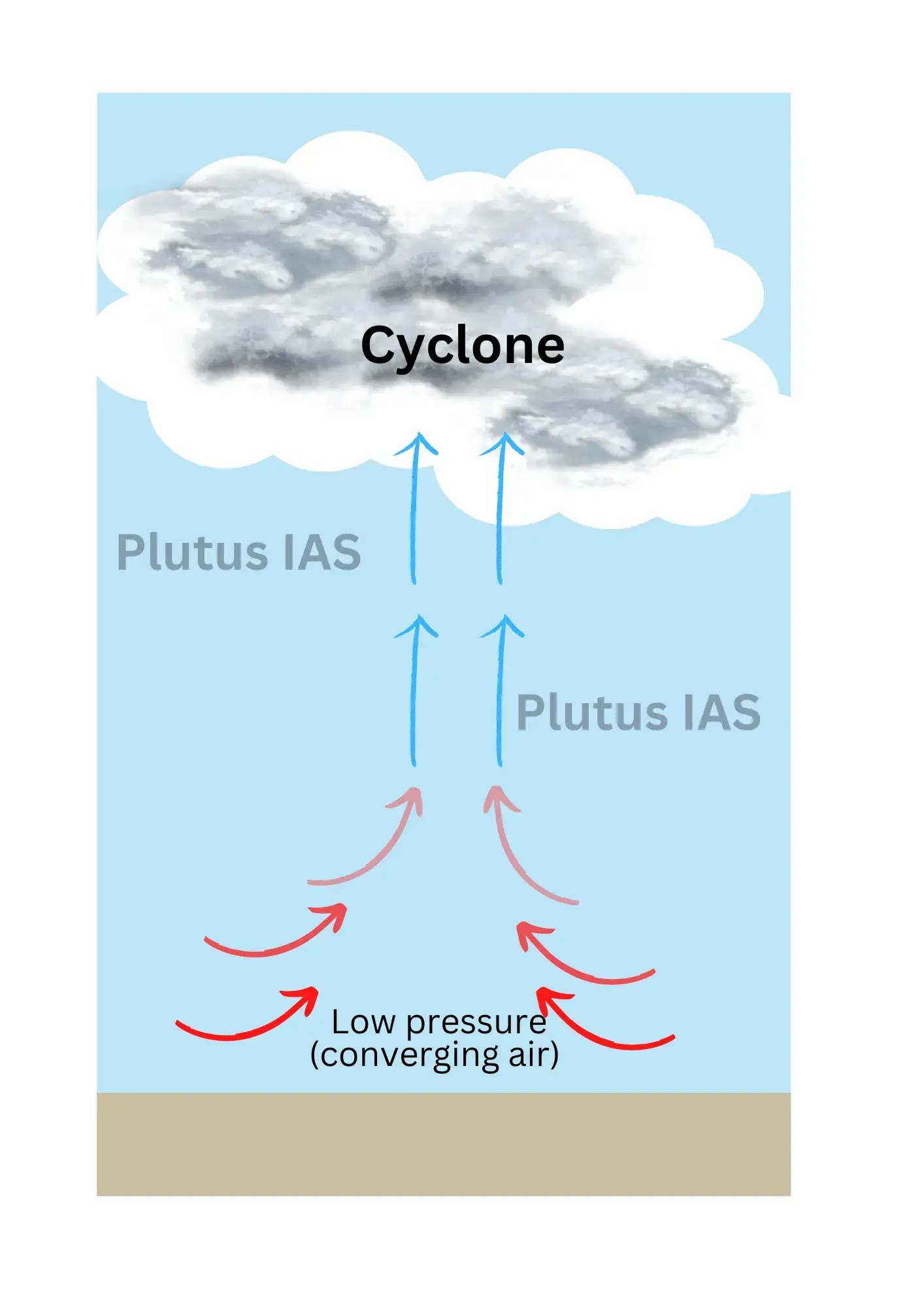
Cyclones
- These are a type of low-pressure environment with fast inward air circulation.
- The air flows counterclockwise in the Northern Hemisphere, on the other hand in the Southern Hemisphere, it flows clockwise.
- The cyclone is usually accompanied by violent storms and bad weather.
- Storms and poor weather are often associated with cyclones.
- The cyclone word comes from the Greek word Cyclos, which means snake coils.
- The term was invented by Henry Paddington because tropical storms in the Bay of Bengal and the Arabian Sea resemble coiled sea serpents.
Formation of Cyclone
- Cyclogenesis is an important element in the creation and strengthening of cyclones.
- Tropical cyclones happen near the equator over warm ocean water.
- Warm, moist air at the ocean’s surface rises upward.
- Which makes a low-pressure zone close to the surface.
- As a result, cooler air from the surrounding areas flows into the low-pressure area.
- Even this cold air is now warm and moist, and it rises.
- This cycle continues likewise.
- The water in the air cools as warm wet air rises, resulting in the development of clouds.
- This cycle repeats itself, resulting in a cyclone.
- A tropical storm happens when winds exceed 63 miles/ hour, and a tropical cyclone or hurricane happens when winds reach 119 miles /hour.
Common names of Cyclone
cyclones are referred to by different names, in different areas.
- Hurricanes – In the Atlantic and Eastern Pacific.
- Typhoons – In Southeast Asia
- Cyclone – In the Indian Ocean and Western Pacific around Australia.
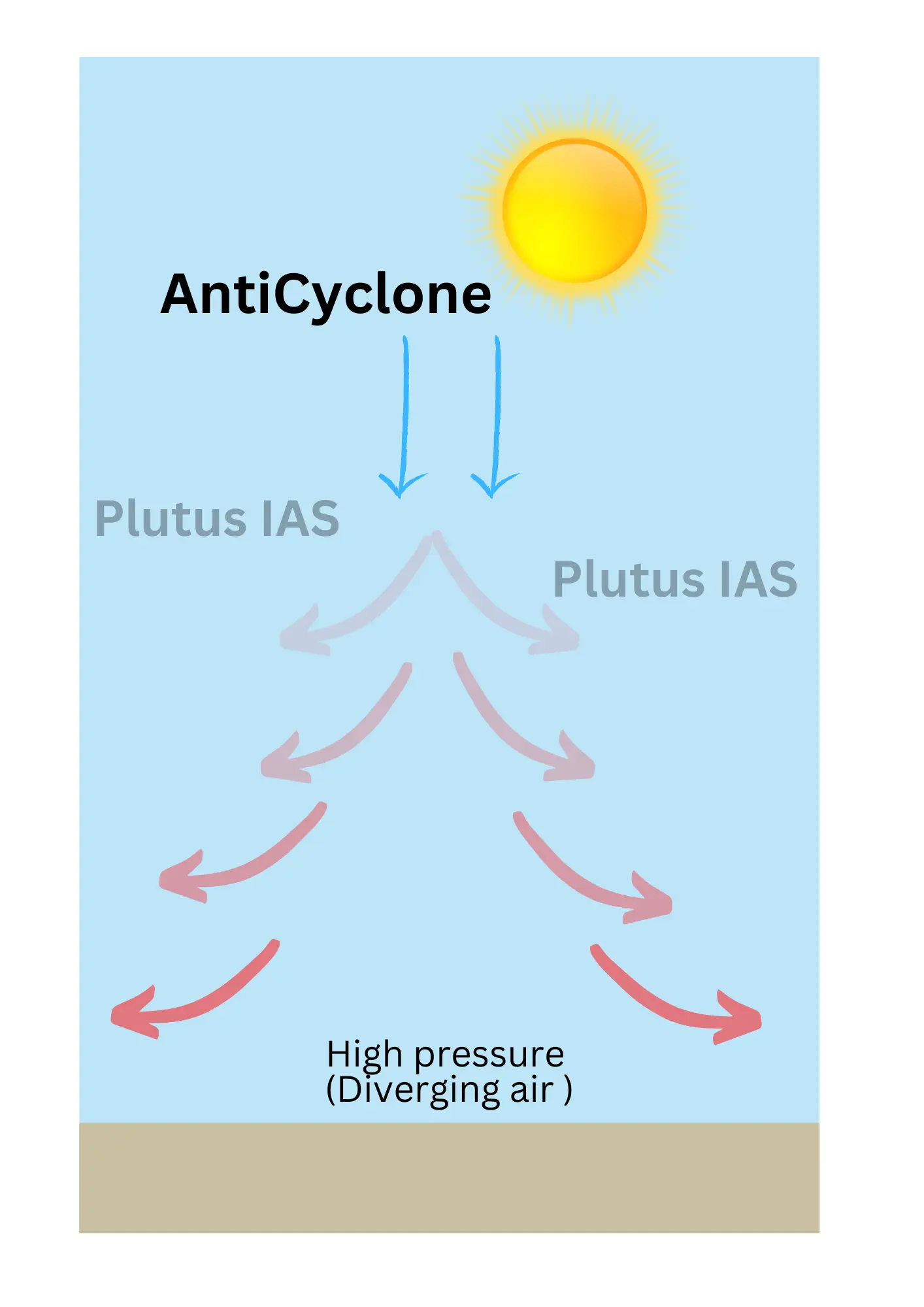
Anticyclones
- An anticyclone is the reverse situation of a cyclone i.e. it has an outward-spiraling air circulation
- nearby a high-pressure center.
- An anticyclone’s winds rotate clockwise in the Northern Hemisphere around a center of high
- pressure.
- In this situation, air comes in from above and sinks to the ground. High-pressure centers usually
- have fair weather.
Pic: Sitrang Cyclone
Pic: AntiCyclone
How the cyclones are named?
- An international committee of the World Meteorological Organisation maintains and updates cyclone lists and names (WMO).
- In the original list, only women’s names were there.
- In 1979, Men’s names were included in the list.
- Men’s and women’s names are alternately used.
- Six different lists are used in a rotating fashion.
- Hence, the 2020 list will be used again in 2026.
- .For genuine reasons, if the storms have imposed damage on a country, the name will not be mentioned again.
- Such names are
- Katrina in the United States (2005),
- Sandy in the United States (2012),
- Haiyan in the Philippines (2013),
- Irma, and Maria in the Caribbean (2017).
Types of Cyclones
On the basis of the prevailing low-pressure system, cyclones are categorized into two types:
- Extra-tropical cyclones.
- Tropical cyclones.
Extratropical Cyclone
- Extratropical cyclones are described the mid-latitude depressions, temperate cyclones, frontal
- Depressions and wave cyclones.
- These cyclones are functions above the mid-latitudinal region between 35° and 65° latitude in
- both the hemispheres.
- In the winter seasons, the direction of movement is from west to east and is more pronounced.
- Fronts are formed in the latitudinal zone where the polar and tropical air masses meet.
- Formation
- The polar front theory explains the origin and development of this.
- As per the theory, the warm-humid air mass from the tropics encounters the dry-cold air masses from the poles and hence a polar front occurs.
- As the cold air mass is denser and heavier, the warm air mass is moved up.
- This interchange of cold and warm air masses creates instability and low pressure is happened at
- the junction, particularly in the center of interactions.
- Hence, due to low pressure, a void is created. The air around rushed in to occupy
- this void and coupled with the earth’s rotation a cyclone is formed.
- These cyclones present a contrast to the more violent cyclones or hurricanes of the tropics, which occurs in regions of relatively uniform temperatures.
Air Mass
- This is a very large body of air whose properties of temperature and humidity at any fixed altitude, are fairly similar.
- It can envelope many hundreds of square miles of area.
- It can have a small amount of horizontal variation in temperature and moisture throughout the air
- mass.
- When an air mass remains over a homogenous area for a considerable long time, it obtains the
- characteristics of the area. The homogenous regions can be the extensive ocean surface or extensive plains.
Fronts
- When two air masses having distinctly different properties meet, the frontier zone between them is known as a front.
- The 4 types of fronts
Stationary front:
When the front remains stationary
Cold front:
The contact zone is termed as the cold front, when the cold air moves towards the warm air mass, the,
Warm front:
When the warm air mass shifts towards the cold air mass, the contact zone is a warm front.
Occluded front:
When an air mass is fully lifted above the land surface, then it is known as an occluded front.
The fronts take place in middle latitudes and are characterized by steep gradients in temperature and
pressure.
They bring sudden changes in temperature and cause the air to rise to form clouds and cause precipitation.
Tropical Cyclone
- They are violent storms that develop over oceans in tropical areas and shift over to coastal areas.
- It causes huge destruction by violent winds, very heavy rainfall, and storm surges.
- The winds move counterclockwise in the Northern Hemisphere and clockwise in the Southern Hemisphere.
Favorable condition
- Huge sea surface holding a temperature of 27° C +;
- Presence of the Coriolis force;
- A small change in the vertical wind speed;
- pre-existing weak low-pressure area or low-level-cyclonic circulation;
- Upper divergence above the sea level system.Characteristics
 Eye of the Cyclone
- The “eye” of a cyclone is generally referred to as the circular area of comparatively light winds and fair weather found at the center of a severe tropical cyclone.
- There is very less precipitation and often blue sky or stars can be seen.
- Particularly, the eye of a cyclone refers to the region, in which it has the lowest surface pressure and warmest temperatures aloft (in the upper levels) –the temperature in the eye can be 10°C warmer or more at an altitude of 12 km than the surrounding environment, however only 0-2°C warmer at the surface in the tropical cyclone.
- Eyes can vary in size from 8 km to over 200 km across, but usually, they are around 30-60 km in diameter.
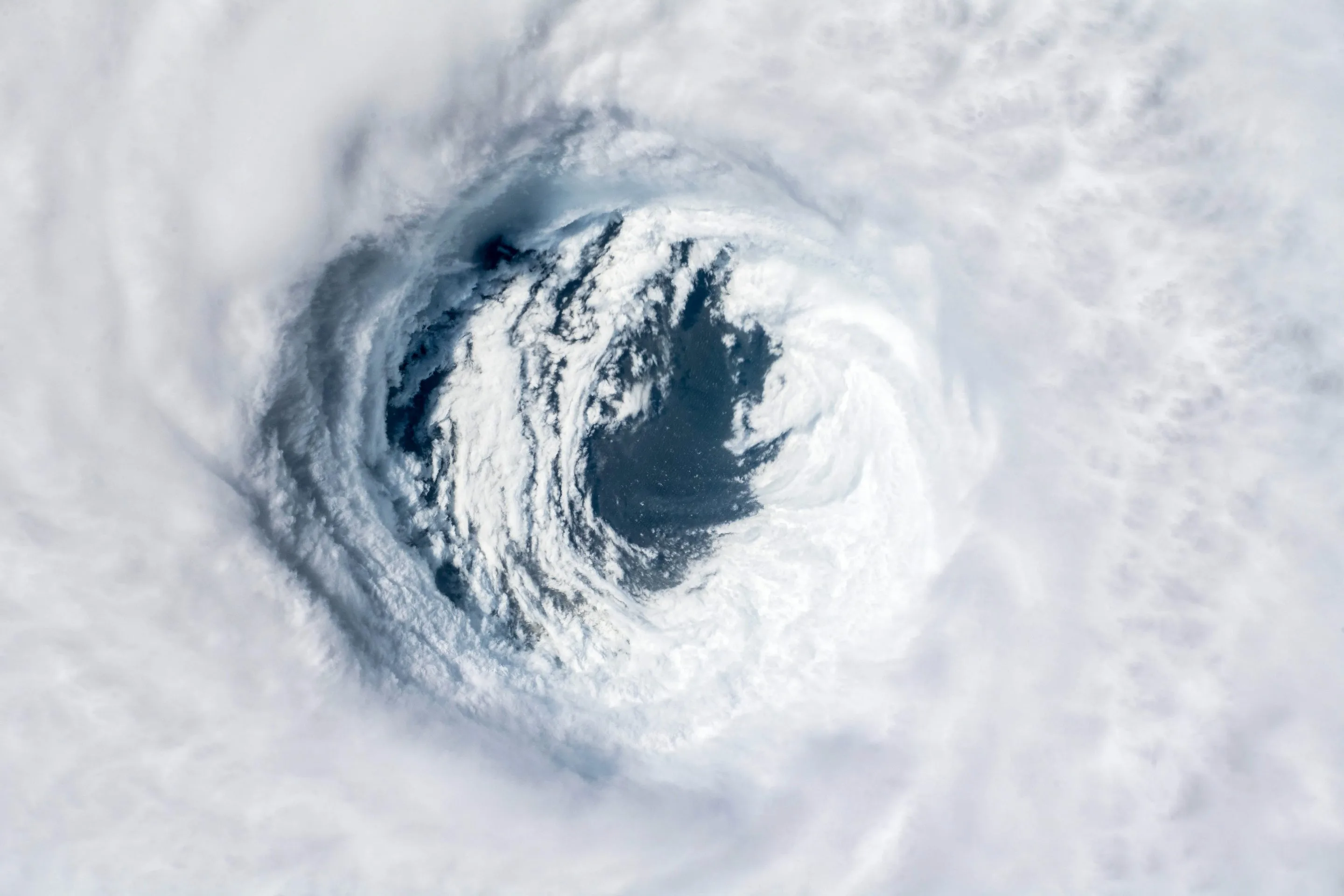
Pic: Eye of the Cyclone
Eyewall
- The eye is enveloped by the “eye wall”, close to a circular ring of deep convection, it is the area of highest surface winds in the tropical cyclone.
- This region also experiences the highest sustained winds, which means it has the fastest winds in a cyclone that happens along the eyewall region.
- The eye is made of air that is slowly sinking and the eye wall has a net upward flow as a result of many moderate – occasionally strong – updrafts and downdrafts [Explained in ‘Thunderstorms’].
- The eye has temperatures because of the compression warming (adiabatic) of the subsiding air.
Indian tropical cyclones :
- Tropical cyclones that hit India usually originate in the eastern side of India.
- The Bay of Bengal is more vulnerable e to cyclones than the Arabian Sea, because, the Bay of Bengal receives high sea surface temperature, and low vertical shear winds and has enough moisture in the middle layers of its atmosphere.
- The frequency of cyclones in the region of the Bay of Bengal is bi-modal, as a result, the Cyclones occur in the months of May–June and October–November.
Indian cyclonic management
India is extremely vulnerable to cyclones. 8% of the total area in India is prone to cyclones.
India has a 7,516 km long coastline, and 5,700 km of the coastline is prone to cyclones of various degrees.
Loss due to cyclones:
- Loss of lives, livelihood opportunities, damage to public and private property and severe damage to infrastructure is the resultant consequences, these losses can disturb the process of development
- Indian Meteorological Department (IMD) is the nodal agency which provides early warning of cyclones and floods.
- Natural Disaster Management Authority is directed to deal with disaster management in India. It has prepared National Guidelines on the Management of Cyclones.
- The Home Ministry has established the National Cyclone Risk Mitigation Project (NCRMP to upgrade the forecasting, tracking and warning regarding cyclones in states.
- National Disaster Response Force (NDRF) has done a commendable performance in rescuing and managing relief work.
Sources
Download PDF:
Download Plutus IAS Current Affairs 26th Oct 2022
Best Current Affairs for UPSC
Nowadays Current affairs are very important for any competitive examination. Without reading current affairs, you will not pass any Job examination. Reading current affairs is part and parcel of passing UPSC examination. Plutus IAS is providing Best Current Affairs for UPSC examination free of cost. The topic described above is related to the subject of Geography, Bio-diversity, and Climate Change. So get such kind of updated news from Plutus IAS daily current affairs page.
- Gurdwara Panja Sahib - November 7, 2022
- UNICEF report - October 31, 2022
- PoK reunites with India: - October 29, 2022

No Comments