


21 Jul UP’s Swamitva Scheme: 1.01 Crore Property Cards Issued in Rural Areas
Subject Relevance — Where This Topic Fits
- GS Paper II — Governance, Transparency and Administrative Reforms | GS Paper III — Land Reforms and Rural Development
- Prelims: SVAMITVA Scheme, Drone-based property mapping, Continuously Operating Reference Station (CORS), Property Card issuance, Panchayati Raj Institutions (PRIs), Land Titling, Digital Land Records
- Essay: Role of technology in rural governance: A case study of SVAMITVA Scheme in Uttar Pradesh, Land reforms and economic empowerment of rural India
Quick Revision: SVAMITVA Scheme leverages drone-based surveys, CORS technology, and ground-level verification to provide legal property rights to rural landowners, reducing disputes and empowering Panchayati Raj Institutions.
Why is this in the news?
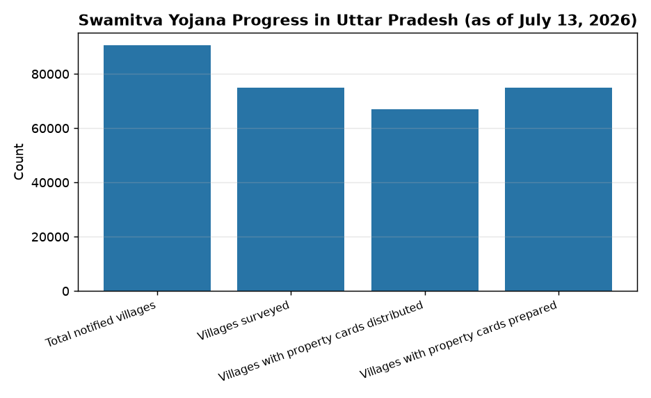
The SVAMITVA (Survey of Villages and Mapping with Improvised Technology in Village Areas) Scheme has achieved a significant milestone in Uttar Pradesh, with drone-based surveys completed in all 90,573 notified villages. The scheme, now extended until September 2026, aims to provide legal property rights to rural landowners, enhance transparency in land records, and empower Panchayati Raj Institutions (PRIs) for better rural governance. This development underscores the Union Government’s commitment to leveraging technology for inclusive rural development and land reform.
Background
- The SVAMITVA Scheme was launched by the Government of India on April 24, 2020, as a Central Sector Scheme under the Ministry of Panchayati Raj, with the objective of providing ‘Record of Rights’ to village household owners in rural inhabited areas.
- The scheme employs advanced technologies such as drone-based aerial surveys, Global Navigation Satellite System (GNSS), and Continuously Operating Reference Station (CORS) for high-precision land mapping and boundary demarcation.
- SVAMITVA is a collaborative effort between the Union Government, state governments, Survey of India, and state revenue departments.
- The scheme aligns with the Digital India Land Records Modernisation Programme (DILRMP) and aims to reduce land disputes, facilitate access to bank loans for rural property owners, and strengthen the revenue administration system.
- Uttar Pradesh, being the most populous state, presents a critical case for the implementation of SVAMITVA, given its vast rural landscape and the need for systematic land titling.
- The scheme is implemented in phases, with priority given to states where drone surveys and property card issuance have seen significant progress, such as Maharashtra, Karnataka, and Madhya Pradesh.
What is the SVAMITVA Scheme?
- The SVAMITVA Scheme is a flagship initiative of the Government of India to provide an integrated property validation solution for rural India using modern technology, thereby reducing land disputes and enhancing rural economic prosperity.
- The scheme is implemented through a multi-stakeholder approach, involving the Union Ministry of Panchayati Raj, state governments, Survey of India, and other technical partners, ensuring accuracy and transparency in land records.
- Key technological components include drone-based aerial surveys, GNSS for high-precision mapping, and CORS for real-time correction of satellite signals, ensuring sub-centimetre accuracy in land boundary delineation.
- The process involves ground-level verification by state revenue officials to resolve objections and disputes before the issuance of property cards, ensuring that the records reflect the actual ground situation and are legally tenable.
- Property cards issued under SVAMITVA serve as legal documents, enabling rural landowners to use their property as collateral for bank loans, access government welfare schemes, and participate in the formal economy.
- The scheme empowers Panchayati Raj Institutions (PRIs) by providing them with accurate land records, which can be utilised for better local governance, planning, and revenue generation.
- SVAMITVA also facilitates the creation of a comprehensive digital land records database, which can be integrated with other government schemes such as PM-KISAN, PM-AWAS, and MGNREGA for improved service delivery.
- The scheme is designed to be inclusive, covering all rural inhabited areas, including those with complex land tenure systems, and ensuring that marginalised sections of society, such as Scheduled Castes and Scheduled Tribes, benefit from the digitisation of land records.
Key Features
| Feature | Significance |
|---|---|
| Drone-based survey and mapping | Enables precise delineation of rural property boundaries, reducing disputes and ensuring accurate land records. |
| Continuously Operating Reference Station (CORS) technology | Provides high-accuracy geospatial data for mapping, enhancing the reliability of property records. |
| Ground-level verification and dispute resolution | Ensures transparency by addressing objections and resolving conflicts before issuing property cards. |
| Issuance of property cards | Formalises land ownership rights, facilitating access to credit, government schemes, and legal security for rural landowners. |
| Extension of the scheme until September 2026 | Allows completion of remaining surveys and issuance of property cards in uncovered villages. |
Why it Matters
Economic
- Facilitates rural credit access by providing verifiable land records, enabling landowners to avail loans against property as collateral.
- Enhances agricultural productivity by reducing land disputes and enabling efficient land use planning.
- Supports rural infrastructure development by providing accurate land records for land acquisition and compensation.
Legal and Administrative
- Strengthens the legal framework for rural property rights, reducing litigation and ensuring clarity in ownership.
- Improves governance by creating a transparent and updatable land record system.
Social
- Empowers rural landowners, particularly marginalised communities, by formalising their property rights.
- Reduces social conflicts arising from land disputes, fostering rural harmony.
Challenges
1. Technological and Infrastructure Gaps
- Limited availability of CORS stations in remote rural areas may affect the accuracy of drone-based surveys.
- Dependence on digital infrastructure for data processing and record-keeping may pose challenges in areas with poor connectivity.
UPSC Link: GS Paper 3: Science & Technology
2. Land Dispute Resolution
- High incidence of pre-existing land disputes may delay the issuance of property cards.
- Inadequate capacity of local authorities to resolve disputes efficiently could undermine the scheme’s objectives.
UPSC Link: GS Paper 2: Governance
3. Awareness and Participation
- Low awareness among rural populations about the scheme’s benefits and processes may lead to underutilisation.
- Lack of participation from marginalised groups could exacerbate existing inequalities in land ownership.
UPSC Link: GS Paper 1: Social Issues
4. Data Privacy and Security
- Risk of data breaches or misuse of geospatial data, particularly if not adequately protected.
- Need for robust cybersecurity measures to safeguard property records and personal data.
UPSC Link: GS Paper 3: Security
Challenges — UPSC Perspective
| Issue | Concern |
|---|---|
| Limited CORS infrastructure | May compromise survey accuracy in remote areas. |
| High pre-existing disputes | Could delay property card issuance and reduce scheme efficacy. |
| Low awareness among rural populations | May hinder participation and limit the scheme’s reach. |
| Cybersecurity risks | Potential for data breaches or misuse of geospatial data. |
| Capacity constraints in local authorities | May impede efficient dispute resolution and implementation. |
Government Initiatives — Must-Memorise for Prelims
- Swamitva Scheme (Survey of Villages and Mapping with Improvised Technology in Village Areas)
- Digital India Land Records Modernisation Programme (DILRMP)
Way Forward
- Strengthen CORS infrastructure in remote rural areas to ensure high-accuracy surveys.
- Enhance capacity-building for local authorities to expedite dispute resolution and verification processes.
- Launch targeted awareness campaigns in rural areas to educate landowners about the scheme’s benefits and processes.
- Integrate the scheme with other rural development initiatives to maximise its socio-economic impact.
- Develop robust cybersecurity protocols to safeguard property records and geospatial data.
- Establish grievance redressal mechanisms for timely resolution of disputes and objections.
- Promote the use of property cards for accessing credit and government schemes to incentivise participation.
- Monitor and evaluate the scheme’s progress to identify bottlenecks and implement corrective measures.
UPSC Value Addition
Keywords for Mains Answer-Writing
SVAMITVA Scheme · Drone-based property survey · Continuously Operating Reference Station (CORS) · Property rights in rural India · Land records digitisation · Panchayati Raj Institutions · Property card issuance · Rural land disputes resolution · Geospatial technology in governance · Digital India Land Records Modernisation Programme (DILRMP) · Land titling and ownership security · Gramm Panchayat development
Concept Flow
Rural land disputes and lack of formal ownership records → Government launches Swamitva Scheme → Drone-based surveys and CORS technology used for mapping → Ground-level verification and dispute resolution → Issuance of property cards → Formalisation of land ownership rights → Enhanced access to credit and government schemes → Socio-economic empowerment of rural landowners
Prelims Practice Questions
Q1. Consider the following statements regarding the SVAMITVA Scheme: 1. It is a centrally sponsored scheme for mapping rural properties using drone technology. 2. The scheme utilises CORS technology for accurate land boundary demarcation. 3. Property cards are issued directly without any ground-level verification. 4. The scheme aims to provide a record of rights to property owners in rural areas. Which of the statements given above are correct?
- 1, 2 and 3 only
- 1, 2 and 4 only
- 2, 3 and 4 only
- 1, 2, 3 and 4
Answer: 1, 2 and 4 only — Statements 1, 2, and 4 are correct as per the scheme’s objectives and methodology. Statement 3 is incorrect because the scheme mandates ground-level verification and dispute resolution before issuing property cards.
Q2. Which of the following is NOT a component of the SVAMITVA Scheme?
- Drone-based aerial survey of rural properties
- Issuance of property cards to landowners
- Use of CORS technology for geospatial accuracy
- Mandatory registration of all rural properties under the Registration Act, 1908
Answer: Mandatory registration of all rural properties under the Registration Act, 1908 — The SVAMITVA Scheme does not mandate registration under the Registration Act, 1908. It focuses on surveying, mapping, and issuing property cards to establish ownership records in rural areas.
Mains Practice Question
✍ The SVAMITVA Scheme represents a transformative approach to land governance in rural India. Elaborate on the scheme’s objectives, technological interventions, and its potential socio-economic impact. Also discuss the challenges in its implementation and suggest measures to enhance its effectiveness.
Approach: Begin by defining the SVAMITVA Scheme and its core objectives, such as digitising land records and securing property rights in rural areas. Explain the technological framework, including drone-based surveys and CORS technology, and highlight the role of ground-level verification. Analyse the scheme’s impact on rural development, dispute resolution, and financial inclusion. Discuss challenges like data accuracy, stakeholder coordination, and digital divide. Conclude with recommendations such as strengthening institutional capacity, leveraging public-private partnerships, and integrating the scheme with other land governance initiatives like DILRMP.
Source: PIB (Press Information Bureau)
Generated by AanyaAi for educational purpose.

- यूपी नीट यूजी काउंसलिंग राउंड-2: मेरिट लिस्ट हुई जारी, 22 सितंबर से रिपोर्टिंग शुरू - September 21, 2026
- UP NEET UG Counselling 2026 Round 2: Merit List Out, Key Dates & Reporting Process - September 21, 2026
- UPSC Civil Services (Main) Examination 2026 — Geology Optional Paper I: Question Paper | Plutus IAS - September 21, 2026

No Comments