


21 Jul UP’s Swamitva Scheme: 83% Villages Covered, 1.2 Cr Property Cards Issued
Subject Relevance — Where This Topic Fits
- GS Paper II — Governance, Transparency and Accountability | GS Paper III — Land Reforms, Rural Development and Digital Infrastructure
- Prelims: SVAMITVA Scheme, Property rights in rural areas, Drone-based land mapping, Continuously Operating Reference Station (CORS), Property cards under SVAMITVA
- Essay: Land reforms and rural empowerment: The role of technology in governance, Balancing transparency and equity in property rights distribution
Quick Revision: The SVAMITVA Scheme in Uttar Pradesh has utilised drone-based surveys and CORS technology to issue property cards, enhancing rural land governance and reducing disputes through transparent and technology-driven processes.
Why is this in the news?
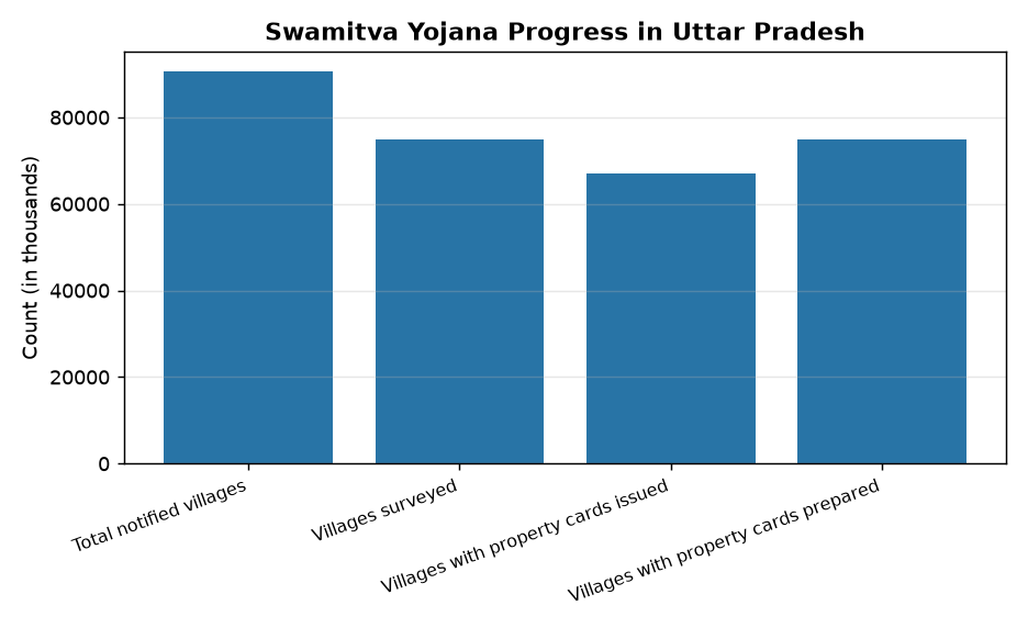
The Union Minister of State for Panchayati Raj, Shri Rajiv Ranjan Singh alias Lalan Singh, informed the Lok Sabha on 21 July 2026 that the SVAMITVA Scheme in Uttar Pradesh has achieved significant milestones, with drone surveys completed in all 90,573 notified villages and property cards distributed to approximately 67,000 villages. The scheme has been extended until September 2026 to further expand its coverage and resolve disputes, highlighting its role in enhancing rural land governance through technology-driven transparency.
Background
- The SVAMITVA (Survey of Villages and Mapping with Improvised Technology in Village Areas) Scheme was launched by the Government of India to provide property rights to rural landowners through a drone-based survey and mapping system.
- The scheme is implemented by the Ministry of Panchayati Raj in collaboration with State Revenue Departments, Survey of India, and National Informatics Centre (NIC).
- The primary objective is to create a clear and unambiguous record of land ownership in rural areas, thereby reducing property disputes and enabling better access to credit and welfare schemes.
- Uttar Pradesh, with its vast rural landscape, is a critical state for the scheme’s implementation, given its large number of notified villages and high population density.
- The scheme utilises advanced technologies such as Drone-based surveys and Continuously Operating Reference Station (CORS) for precise land mapping and boundary delineation.
- The scheme also includes a grievance redressal mechanism to resolve disputes and objections before issuing property cards, ensuring transparency and accuracy.
What is the SVAMITVA Scheme?
- The SVAMITVA Scheme is a Central Sector Scheme aimed at providing property rights to rural landowners through a technology-driven approach, primarily using drone-based surveys and CORS technology.
- The scheme seeks to create a comprehensive and up-to-date record of land ownership in rural areas, which is essential for reducing disputes and facilitating economic activities such as land transactions and access to credit.
- Under the scheme, property cards are issued to rural landowners, which serve as legal documents establishing their ownership rights over the land.
- The scheme employs advanced technologies like drones for aerial surveys and CORS for high-precision geospatial data, ensuring accurate mapping and boundary delineation.
- A key feature of the scheme is the integration of a grievance redressal mechanism, where local authorities conduct ground-level verification and resolve objections or disputes before issuing property cards.
- The scheme is implemented in a phased manner across states, with Uttar Pradesh being one of the leading states in terms of coverage and progress.
- The property cards issued under the scheme also enable landowners to utilise their land as collateral for loans, thereby enhancing financial inclusion in rural areas.
- The scheme aligns with the broader objectives of the Digital India Land Records Modernisation Programme (DILRMP), which aims to digitise land records and improve land governance.
Key Features
| Feature | Significance |
|---|---|
| Drone-based Survey | Enables high-precision mapping of rural land parcels, reducing human error and ensuring accurate boundary delineation. |
| CORS Technology | Provides real-time geospatial corrections for drone surveys, enhancing the reliability of property records. |
| Property Card Distribution | Issues legal documents to rural landowners, establishing clear ownership rights and reducing disputes. |
| Gram Sabha Verification | Involves local governance bodies in validating survey data, ensuring community participation and transparency. |
| Dispute Resolution Mechanism | Systematic process for addressing objections before card issuance, fostering trust in land records. |
Why it Matters
Economic
- Facilitates access to formal credit by providing verifiable land ownership records, enabling rural land monetisation.
- Reduces transaction costs in land markets by eliminating ambiguity in property boundaries.
- Enhances agricultural productivity through secure land tenure, encouraging long-term land investments.
Legal-Administrative
- Strengthens the land revenue administration system by creating a digital repository of property records.
- Supports implementation of welfare schemes requiring land ownership verification (e.g., PM-KISAN, PM-AWAS).
- Provides a foundation for land titling reforms, aligning with the National Land Records Modernisation Programme (NLRMP).
Social
- Empowers marginalised landowners, particularly women and Scheduled Castes/Tribes, by formalising their property rights.
- Mitigates land disputes, which often lead to social tensions and litigation in rural areas.
- Promotes financial inclusion by enabling landowners to use property as collateral for loans.
Challenges
1. Technological Limitations
- Dependence on high-precision drone surveys requires robust technical infrastructure and trained personnel.
- CORS network coverage may be uneven in remote or hilly terrains, affecting survey accuracy.
UPSC Link: GS-III: Science & Tech
2. Administrative Bottlenecks
- Coordinating between multiple agencies (e.g., Survey of India, state revenue departments) can delay implementation.
- Ensuring Gram Sabha participation and resolving objections require sustained administrative effort.
UPSC Link: GS-II: Governance
3. Legal and Socio-Cultural Barriers
- Traditional landholding systems (e.g., community ownership) may resist formalisation due to perceived loss of customary rights.
- Lack of awareness among rural populations about the benefits of property cards can hinder adoption.
UPSC Link: GS-II: Social Justice
4. Data Privacy and Security
- Digitisation of land records raises concerns about data breaches and unauthorised access to sensitive information.
- Ensuring cybersecurity for the digital repository of property records is critical.
UPSC Link: GS-III: Internal Security
Challenges — UPSC Perspective
| Issue | Concern |
|---|---|
| Infrastructure Gaps | Inadequate CORS network in remote areas may compromise survey accuracy. |
| Inter-Agency Coordination | Delays in land record digitisation due to lack of synergy between central and state agencies. |
| Community Resistance | Traditional land tenure systems may hinder acceptance of formal property rights. |
| Awareness Deficit | Limited outreach to rural populations about the benefits of SWAMITVA cards. |
| Cybersecurity Risks | Vulnerability of digital land records to hacking or data leaks. |
Way Forward
- Expand CORS network coverage to ensure uniform geospatial accuracy across all rural regions.
- Strengthen Gram Sabha engagement through awareness campaigns and capacity-building workshops.
- Integrate SWAMITVA data with other land-related schemes (e.g., PM-KISAN, Digital Land Records) for seamless service delivery.
- Establish a grievance redressal mechanism for unresolved property disputes to enhance trust in the system.
- Develop a state-level monitoring dashboard to track progress and address bottlenecks in real time.
- Collaborate with academic institutions to train local surveyors in drone-based mapping technologies.
- Ensure data privacy by implementing encryption protocols and strict access controls for digital land records.
UPSC Value Addition
Keywords for Mains Answer-Writing
SVAMITVA Scheme · Drone-based property survey · Property rights in rural India · Continuously Operating Reference Station (CORS) · Land records modernisation · Panchayati Raj Institutions · Digital mapping of rural land · Property card issuance · Land disputes resolution · Rural land governance · Ministry of Panchayati Raj · E-governance in land records
Constitutional & Policy Linkages
- Article 39(b): Directive Principle promoting equitable distribution of resources through secure land tenure.
- Article 46: Directive Principle for protecting weaker sections from economic exploitation via land rights.
Concept Flow
Rural land disputes and lack of formal ownership records → Launch of SWAMITVA Scheme (2020) → Drone-based survey using CORS technology → Gram Sabha verification and dispute resolution → Issuance of property cards → Formalisation of land rights → Enhanced access to credit and welfare schemes.
Prelims Practice Questions
Q1. Consider the following statements regarding the SVAMITVA Scheme: 1. It aims to provide property rights to rural landowners through drone-based surveys. 2. The scheme utilises Continuously Operating Reference Station (CORS) technology for accurate mapping. 3. Property cards are issued without any ground-level verification to expedite the process. 4. The scheme is implemented under the aegis of the Ministry of Panchayati Raj. Which of the statements given above are correct?
- 1 and 2 only
- 1, 2, and 4 only
- 2, 3, and 4 only
- 1, 3, and 4 only
Answer: 1, 2, and 4 only — Statements 1, 2, and 4 are correct as per the scheme’s objectives and administrative framework. Statement 3 is incorrect because the scheme mandates ground-level verification and dispute resolution before issuing property cards.
Q2. Which of the following is NOT a feature of the SVAMITVA Scheme?
- Use of drone technology for cadastral surveys
- Issuance of property cards to rural landowners
- Resolution of land disputes through state authorities
- Mandatory digitisation of urban property records
Answer: Mandatory digitisation of urban property records — The SVAMITVA Scheme focuses exclusively on rural property records. The digitisation of urban property records is not a part of this scheme.
Mains Practice Question
✍ Examine the significance of the SVAMITVA Scheme in the context of rural land governance and dispute resolution. How does the integration of drone-based surveys and CORS technology enhance the efficacy of land records management in India? Substantiate your answer with relevant examples.
Approach: Begin by outlining the objectives and administrative structure of the SVAMITVA Scheme, highlighting its role in providing property rights to rural landowners. Discuss the challenges in rural land governance, such as disputes and lack of clear records, and explain how drone-based surveys and CORS technology address these issues by ensuring accurate mapping and transparency. Conclude by assessing the broader implications for rural development, financial inclusion, and governance reforms, citing the scheme’s expansion and its impact on Panchayati Raj Institutions.
Source: PIB (Press Information Bureau)
Generated by AanyaAi for educational purpose.

- यूपी नीट यूजी काउंसलिंग राउंड-2: मेरिट लिस्ट हुई जारी, 22 सितंबर से रिपोर्टिंग शुरू - September 21, 2026
- UP NEET UG Counselling 2026 Round 2: Merit List Out, Key Dates & Reporting Process - September 21, 2026
- UPSC Civil Services (Main) Examination 2026 — Geology Optional Paper I: Question Paper | Plutus IAS - September 21, 2026

No Comments