


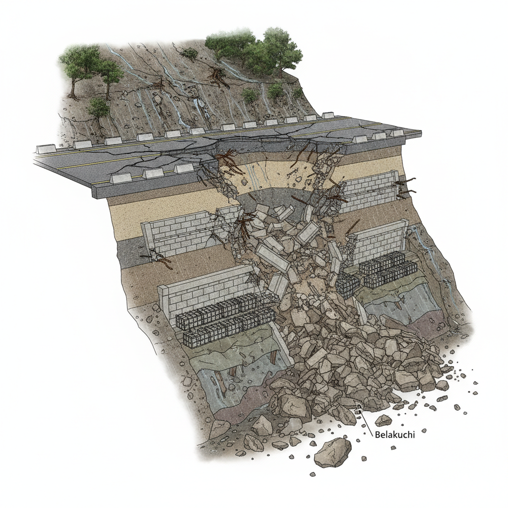
08 Aug Badrinath Highway Collapse: All-Weather Road Project Fails Monsoon Test
✎ Geotechnical stability in Himalayan road projects must prioritize site-specific hazard mapping, rigorous EIA compliance, and post-construction monitoring to prevent structural failures in landslide-prone zones.
Subject Relevance — Where This Topic Fits
- GS Paper III — Infrastructure: Energy, Ports, Roads, Airports, Railways; Environmental Impact Assessment | GS Paper III — Disaster Management
- Prelims: Landslide-prone zones, All-weather road projects, Geotechnical engineering, National Highways Authority of India (NHAI), Border Roads Organisation (BRO), Environmental Impact Assessment (EIA) 2006, Himalayan ecology, Disaster risk reduction
- Essay: Infrastructure development vs. environmental sustainability in fragile ecosystems, Balancing development imperatives with ecological conservation in the Himalayas
Quick Revision: Geotechnical stability in Himalayan road projects must prioritize site-specific hazard mapping, rigorous EIA compliance, and post-construction monitoring to prevent structural failures in landslide-prone zones.
Why is this in the news?
The Badrinath Highway segment of the All-Weather Road Project has failed structurally within months of completion, with significant portions of retaining walls collapsing in landslide-prone zones such as Kamera and Belakuchi during the first monsoon season. This incident underscores systemic deficiencies in geotechnical assessments, construction quality control, and long-term resilience planning for critical Himalayan infrastructure, prompting urgent technical reviews and corrective measures by the National Highways and Infrastructure Development Corporation Limited (NHIDCL).
Background
- The Badrinath Highway (National Highway 7) is a strategically vital all-weather road connecting the Char Dham pilgrimage circuit, including the Badrinath shrine, to the national highway network.
- The All-Weather Road Project, executed under the NHIDCL (a nodal agency under the Ministry of Road Transport and Highways), aims to provide year-round connectivity to high-altitude Himalayan regions, reducing dependence on seasonal closures due to landslides and snow.
- The Himalayas are inherently prone to landslides due to geological instability, steep slopes, high rainfall intensity, and anthropogenic pressures such as deforestation and unplanned construction.
- The Environmental Impact Assessment (EIA) Notification 2006 mandates rigorous assessment of infrastructure projects in ecologically sensitive zones, including the Himalayas, to mitigate risks of environmental degradation and structural failure.
- Past incidents, such as the 2013 Uttarakhand floods and the 2021 Chamoli disaster, have highlighted the vulnerability of Himalayan infrastructure to extreme weather events and geological hazards.
- The project’s failure reflects broader challenges in balancing developmental imperatives with environmental sustainability in fragile mountain ecosystems.
What is the Badrinath All-Weather Road Project?
- The Badrinath All-Weather Road Project is a flagship infrastructure initiative under the NHIDCL, aimed at providing year-round, climate-resilient connectivity to the Badrinath Dham and surrounding high-altitude regions.
- The project involves widening, strengthening, and realigning existing highways, constructing retaining walls, drainage systems, and slope stabilization measures to mitigate landslide risks.
- The project is part of the broader Char Dham All-Weather Road initiative, which seeks to enhance connectivity to four major Hindu pilgrimage sites: Badrinath, Kedarnath, Gangotri, and Yamunotri.
- The project spans approximately 889 km across Uttarakhand, with significant sections traversing landslide-prone zones in the Garhwal and Kumaon Himalayas.
- The project is executed in phases, with critical segments prioritized for completion to ensure early connectivity benefits, particularly for pilgrimage and defense logistics.
- The project’s design incorporates modern geotechnical engineering techniques, including rock bolting, soil nailing, and reinforced earth structures, to enhance slope stability.
- The project’s execution is overseen by NHIDCL in collaboration with state agencies, private contractors, and technical consultants, with funding from the Ministry of Road Transport and Highways.
Key Features
| Feature | Significance |
|---|---|
| All-Weather Road Project | Ensures year-round connectivity to the Badrinath Dham, a critical pilgrimage site in Uttarakhand. |
| Safety Retaining Walls | Designed to prevent landslides and soil erosion along the highway corridor. |
| Geotechnical Engineering Interventions | Includes anchoring and soil nailing techniques to stabilize slopes. |
| NHIDCL Implementation | National Highways and Infrastructure Development Corporation Limited undertakes construction and maintenance. |
| Pilgrimage Infrastructure | Supports the socio-economic and religious significance of the Char Dham Yatra. |
Why it Matters
Strategic Connectivity
- The Badrinath Highway is a vital link for pilgrims and military logistics, connecting the Indo-Tibetan Border Police (ITBP) and Army bases in Uttarakhand.
- Year-round accessibility reduces seasonal disruptions, enhancing socio-economic integration of the region.
- Supports the Char Dham Yatra, a major religious tourism circuit contributing to Uttarakhand’s economy.
Economic Impact
- Facilitates faster movement of goods and services, reducing transportation costs for local businesses.
- Boosts tourism revenue by ensuring reliable access to Badrinath Dham and surrounding areas.
- Creates employment opportunities in construction, maintenance, and allied sectors.
Environmental Considerations
- The project traverses ecologically sensitive zones, requiring adherence to environmental safeguards.
- Landslide-prone areas demand rigorous geotechnical assessments to mitigate ecological damage.
- Balances developmental imperatives with conservation of the Himalayan ecosystem.
Challenges
1. Geological Instability
- Himalayan terrain is inherently prone to landslides due to tectonic activity, steep slopes, and heavy rainfall.
- Recent monsoon spells have exposed structural vulnerabilities in the retaining walls.
- Reactivation of dormant landslide zones (e.g., Kedar and Belakuchi) threatens project durability.
UPSC Link: GS-III: Disaster Management
2. Construction Quality and Durability
- Premature failure of safety walls raises concerns about adherence to engineering standards.
- Inadequate soil testing and anchoring techniques may have contributed to structural collapse.
- Need for post-construction monitoring and maintenance protocols.
UPSC Link: GS-III: Infrastructure Development
3. Climate Change and Extreme Weather
- Increased frequency of intense rainfall events exacerbates landslide risks.
- Climate-induced glacial melt and permafrost thaw destabilize mountain slopes.
- Requires adaptive engineering solutions to withstand changing environmental conditions.
UPSC Link: GS-III: Climate Change
4. Project Implementation Delays
- Geological surprises and unforeseen challenges prolong construction timelines.
- Disruptions to pilgrimage activities during monsoon seasons impact local economies.
- Coordination gaps between NHIDCL, state agencies, and local stakeholders.
UPSC Link: GS-II: Government Policies
5. Environmental Compliance
- Ensuring compliance with the Forest (Conservation) Act, 1980, and environmental impact assessments.
- Balancing developmental needs with the protection of biodiversity-rich Himalayan ecosystems.
- Community resistance due to perceived ecological degradation.
UPSC Link: GS-III: Environmental Conservation
Challenges — UPSC Perspective
| Issue | Concern |
|---|---|
| Landslide Reactivation | Reactivation of dormant landslide zones threatens structural integrity and safety. |
| Retaining Wall Failure | Premature collapse of safety walls exposes gaps in construction quality. |
| Climate Vulnerability | Increased rainfall and glacial melt intensify geological instability. |
| Regulatory Compliance | Delays due to environmental clearances and forest conservation norms. |
| Stakeholder Coordination | Lack of synergy between NHIDCL, state agencies, and local communities. |
| Economic Disruptions | Monsoon-induced delays impact pilgrimage-driven local economies. |
Government Initiatives — Must-Memorise for Prelims
- Char Dham Mahamarg Vikas Pariyojana
Way Forward
- Conduct comprehensive geotechnical audits of all retaining walls and slope stabilization measures.
- Implement real-time monitoring systems (e.g., IoT-based sensors) to detect early signs of structural distress.
- Adopt climate-resilient engineering designs, including flexible retaining structures and drainage improvements.
- Strengthen inter-agency coordination between NHIDCL, Uttarakhand State Disaster Management Authority (USDMA), and local bodies.
- Enhance community engagement to address ecological concerns and ensure project acceptance.
- Prioritize post-construction maintenance schedules to prevent premature failures.
- Integrate lessons from this project into future Himalayan road infrastructure planning.
UPSC Value Addition
Keywords for Mains Answer-Writing
All-Weather Road Project · Badrinath Highway · Geological fragility · National Highways Authority of India (NHAI) · National Highways and Infrastructure Development Corporation Limited (NHIDCL) · Landslide-prone zones · Geotechnical investigations · Slope stability measures · Environmental Impact Assessment (EIA) · Himalayan ecosystem · Road safety · Project sustainability
Concept Flow
Himalayan geological instability (tectonic activity + steep slopes) → Heavy monsoon rainfall → Inadequate geotechnical interventions → Premature failure of retaining walls → Reactivation of landslide zones → Disruption of pilgrimage and strategic connectivity → Economic and ecological repercussions.
Prelims Practice Questions
Q1. Consider the following statements regarding the Badrinath All-Weather Road Project:
1. The project is being executed by the National Highways Authority of India (NHAI).
2. The project aims to provide year-round connectivity to the Badrinath Dham.
3. The project has faced challenges due to landslides in geologically fragile zones.
How many of the above statements are correct?
- Only one
- Only two
- All
- None
Answer: All — Statements 2 and 3 are correct. The project is executed by the National Highways and Infrastructure Development Corporation Limited (NHIDCL), not NHAI. Statement 1 is incorrect.
Q2. Assertion (A): The Himalayan region is highly susceptible to landslides due to its geological fragility.
Reason (R): The Himalayas are young fold mountains with steep slopes and high seismic activity.
In the context of the above assertions, which of the following is correct?
- Both A and R are true, and R is the correct explanation of A.
- Both A and R are true, but R is not the correct explanation of A.
- A is true, but R is false.
- A is false, but R is true.
Answer: Both A and R are true, and R is the correct explanation of A. — Both assertions are true. The Himalayas are geologically young and fragile, making them highly susceptible to landslides. The reason correctly explains the assertion.
Q3. Match the following pairs related to road infrastructure in India:
Column I (Project) | Column II (Executing Agency)
—————————————-|———————————-
A. Badrinath All-Weather Road Project | 1. Border Roads Organisation (BRO)
B. Char Dham Highway Project | 2. National Highways Authority of India (NHAI)
C. Golden Quadrilateral | 3. National Highways and Infrastructure Development Corporation Limited (NHIDCL)
D. Pradhan Mantri Gram Sadak Yojana | 4. State Public Works Departments (PWD)
Select the correct match:
- A-3, B-1, C-2, D-4
- A-2, B-3, C-1, D-4
- A-3, B-2, C-1, D-4
- A-1, B-3, C-2, D-4
Answer: A-3, B-1, C-2, D-4 — A matches with 3 (NHIDCL), B matches with 1 (BRO), C matches with 2 (NHAI), and D matches with 4 (State PWD).
Mains Practice Question
✍ The failure of engineering interventions in geologically fragile zones such as the Badrinath Highway underscores systemic lacunae in infrastructure project execution in the Himalayas. Critically examine the challenges in ensuring the sustainability of such projects, with reference to environmental, technical, and institutional dimensions. (15 Marks)
Approach: MODEL-ANSWER SKELETON:
1. **Environmental Dimension**:
– Himalayas as ecologically sensitive zones (mention Western Himalayas, fragile lithology, high rainfall).
– Role of Environmental Impact Assessment (EIA) 2006 and its limitations in predicting long-term geotechnical risks.
– Climate change exacerbating landslide risks (cite IPCC reports or recent studies on glacial retreat).
2. **Technical Dimension**:
– Inadequate geotechnical investigations: lack of slope stability analysis, poor soil testing, and absence of real-time monitoring systems.
– Failure of traditional engineering solutions (e.g., retaining walls, drainage systems) in high-seismic and high-rainfall zones.
– Case reference: Badrinath Highway project—premature failure of retaining walls in Komeda and Belakuchi zones.
3. **Institutional Dimension**:
– Multiplicity of agencies: NHIDCL, NHAI, State PWD, and local bodies with overlapping jurisdictions.
– Lack of standardized protocols for post-construction monitoring and maintenance.
– Weak enforcement of compliance with environmental safeguards and geotechnical guidelines.
4. **Way Forward**:
– Adoption of modern technologies: LiDAR, remote sensing, and AI-based predictive modeling for risk assessment.
– Integration of local ecological knowledge and community-based monitoring.
– Strengthening institutional frameworks: single-window clearance, mandatory third-party audits, and accountability mechanisms.
5. **Balanced View**:
– Acknowledge the necessity of infrastructure development in remote areas but emphasize the need for sustainable, resilient design.
– Contrast with successful models (e.g., Bhutan’s road safety initiatives or Japan’s slope stabilization techniques).
Source: amarujala.com
Generated by AanyaAi for educational purpose.

- बदरीनाथ हाईवे: पहली बरसात में ढहा ऑल वेदर रोड प्रोजेक्ट, सुरक्षा दीवार का हिस्सा धंस गया - August 8, 2026
- Badrinath Highway Collapse: All-Weather Road Project Fails Monsoon Test - August 8, 2026
- मध्य प्रदेश के सांसद ने सीएम से फसल बीमा प्रीमियम भुगतान की समय सीमा बढ़ाने का आग्रह किया - August 8, 2026

No Comments