


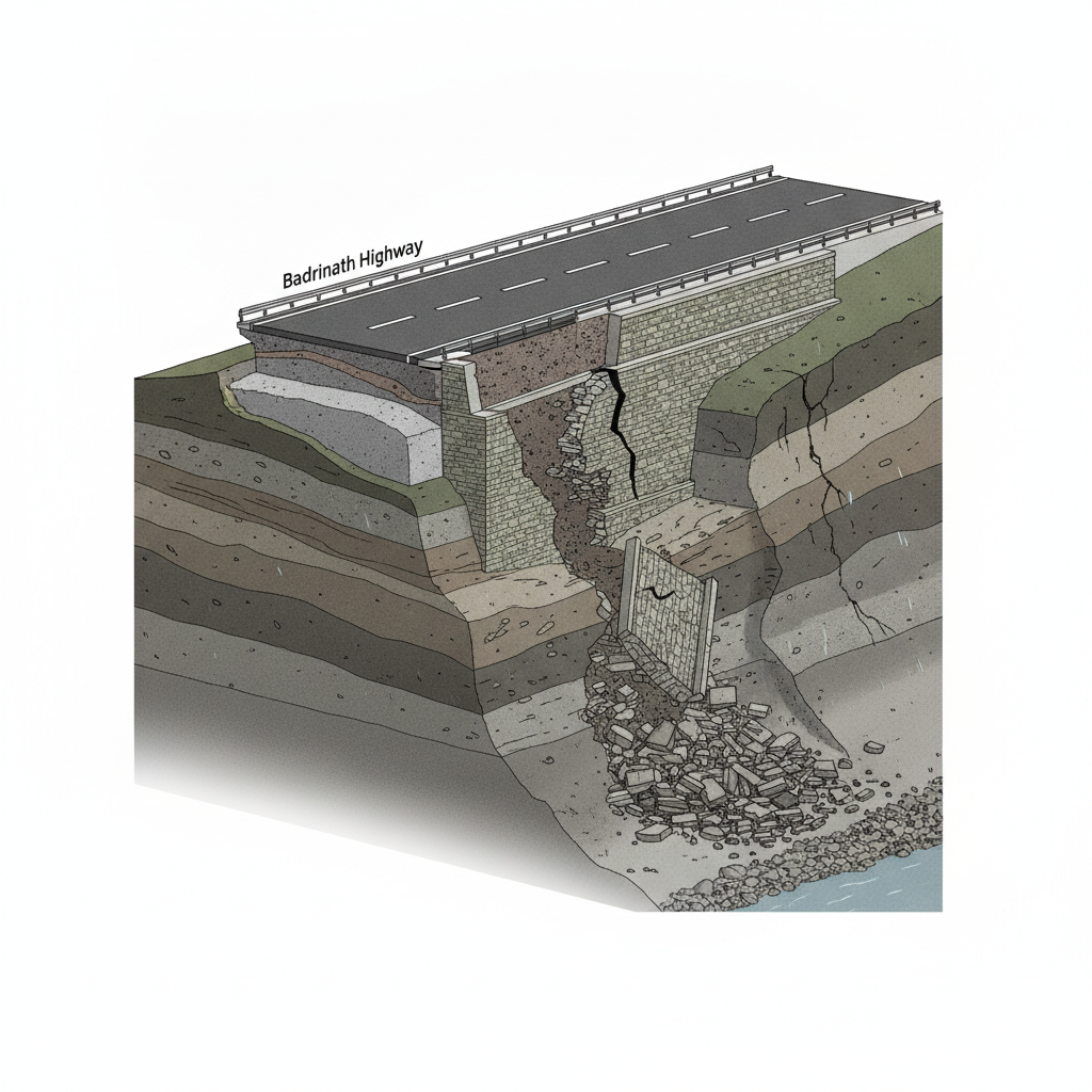
08 Aug Badrinath Highway Failure: All-Weather Road Project Crumbles in First Monsoon
Highway pavementSafety wallConstruction jointsGeological assessment✎ The structural failures in the Badrinath Highway All-Weather Road Project highlight the critical need for rigorous geological surveys, adherence to EIA norms, and real-time monitoring of slope stability in Himalayan road…
Subject Relevance — Where This Topic Fits
- GS Paper II — Governance, Transparency and Accountability in Infrastructure Projects | GS Paper III — Infrastructure: Roads and Highways, Environmental Impact Assessment
- Prelims: National Highway Authority of India (NHAI), NHIDCL (National Highways and Infrastructure Development Corporation Limited), All-Weather Road Project, Geological Survey of India (GSI), Landslide Hazard Zones, Himalayan Ecology, EIA Notification 2006, Geotextiles and Retaining Structures
- Essay: Infrastructure Development vs. Environmental Sustainability: The Case of Himalayan Highways, Balancing Development and Disaster Risk in Fragile Ecosystems
Quick Revision: The structural failures in the Badrinath Highway All-Weather Road Project highlight the critical need for rigorous geological surveys, adherence to EIA norms, and real-time monitoring of slope stability in Himalayan road construction to prevent disasters.
Why is this in the news?
The Badrinath Highway section of the All-Weather Road Project in Uttarakhand has suffered structural failures, including visible cracks in another section near Pipalkoti, within weeks of monsoon rains. The failures have exposed critical lapses in construction quality, geological assessment, and environmental safeguards, raising concerns about the project’s long-term viability and the safety of road users in a seismically and geologically active region.
Background
- The Badrinath Highway is a vital pilgrimage and strategic roadway connecting the holy town of Badrinath to the national highway network, passing through the ecologically fragile Himalayan terrain of Uttarakhand.
- The All-Weather Road Project, executed by NHIDCL under the Ministry of Road Transport and Highways, aims to ensure year-round connectivity to the Char Dham pilgrimage sites, including Badrinath, despite harsh climatic conditions.
- Uttarakhand lies in a high seismic zone (Zone IV and V) and is prone to landslides, cloudbursts, and flash floods, exacerbated by fragile geological formations, steep slopes, and intense monsoon rainfall.
- The project has faced repeated delays and cost overruns due to geological challenges, land acquisition disputes, and environmental clearances, with critics highlighting the lack of comprehensive geological and geotechnical studies.
- The region has witnessed multiple infrastructure failures in recent years, including road collapses and landslides during monsoons, such as the 2021 Joshimath crisis and the 2023 Tehri landslides, underscoring systemic vulnerabilities in Himalayan road construction.
- Environmentalists argue that the project violates the Environmental Impact Assessment (EIA) Notification 2006, as it lacks rigorous assessments for slope stability, drainage, and ecosystem disruption in a biodiversity-rich and disaster-prone zone.
What is the All-Weather Road Project in Uttarakhand?
- The All-Weather Road Project is a flagship initiative of the Government of India to ensure year-round accessibility to the Char Dham pilgrimage sites (Badrinath, Kedarnath, Gangotri, and Yamunotri) in Uttarakhand, which are currently accessible only during the summer months due to heavy snowfall and landslides.
- The project is implemented by the National Highways and Infrastructure Development Corporation Limited (NHIDCL), a public sector undertaking under the Ministry of Road Transport and Highways, with a budget of over ₹12,000 crore for the Uttarakhand segment.
- The project involves widening and strengthening existing roads, constructing new alignments, and deploying advanced engineering solutions such as geotextiles, retaining walls, and drainage systems to mitigate landslide risks.
- The Badrinath Highway segment, spanning approximately 300 km, passes through some of the most geologically unstable zones in the Himalayas, including the Mandakini and Alaknanda valleys, which are prone to landslides and debris flows.
- Key engineering interventions include the use of reinforced soil slopes, rock bolting, and gabion walls to stabilise steep slopes, alongside the construction of check dams and culverts to manage water runoff.
- The project is part of the broader ‘Char Dham Mahamarg Vikas Pariyojana’, which aims to enhance connectivity, reduce travel time, and improve the safety of pilgrims and local communities in the region.
- Despite these measures, the project has faced criticism for inadequate pre-construction geological surveys, poor quality control in material selection, and insufficient post-construction monitoring of structural integrity.
Key Features
| Feature | Significance |
|---|---|
| All-Weather Road Project (Badrinath Dham) | A strategic infrastructure initiative to ensure year-round connectivity to the Char Dham pilgrimage route, enhancing socio-economic integration of Uttarakhand’s remote Himalayan regions. |
| Slope Stabilisation Measures (Retaining Walls & Anchoring) | Critical engineering interventions to mitigate landslide risks in geologically fragile Himalayan terrains, ensuring structural integrity of road infrastructure. |
| Geological Vulnerability (Kameda & Belakuchi Zones) | High-risk landslide-prone areas where unconsolidated debris, steep slopes, and monsoonal precipitation exacerbate slope failures, necessitating advanced mitigation strategies. |
| Premature Structural Failure | Demonstrates inadequacy of construction quality control and site-specific geological assessments, raising concerns over durability and long-term viability of such projects. |
| NHIDCL’s Immediate Response (Soil Filling & Traffic Management) | Operational measures to restore partial functionality of the highway, highlighting the need for systemic risk assessment and adaptive management in disaster-prone zones. |
Why it Matters
Strategic Infrastructure
- Ensures uninterrupted pilgrimage access to Badrinath Dham, a key religious and tourism hub in Uttarakhand, critical for socio-economic sustenance of local communities.
- Facilitates military logistics and disaster response in the Indo-Tibetan border region, aligning with national security imperatives.
- Promotes regional connectivity, reducing travel time and costs for pilgrims and tourists, thereby boosting local economies.
Geological & Environmental Concerns
- Highlights the Himalayas’ inherent fragility, where anthropogenic interventions (road construction) often trigger cascading geohazards like landslides and slope failures.
- Underscores the necessity of integrating climate-resilient design principles in Himalayan infrastructure to withstand extreme weather events exacerbated by climate change.
- Raises questions about the ecological footprint of such projects, including deforestation, slope destabilisation, and sediment runoff into river systems.
Economic Implications
- Failure of critical infrastructure imposes financial burdens on exchequer due to repeated repairs and mitigation efforts, diverting resources from other developmental priorities.
- Disruptions in pilgrimage tourism directly impact livelihoods of local vendors, transporters, and hospitality sectors, exacerbating economic vulnerabilities.
- Erosion of public trust in government-led infrastructure projects may deter private investments in similar ventures.
Challenges
1. Geotechnical Instability in Himalayan Terrains
- Unpredictable geological formations (e.g., loose moraines, fractured rocks) complicate slope stabilisation efforts, requiring advanced geotechnical investigations.
- Monsoonal precipitation intensifies slope failures, necessitating pre-emptive drainage systems and real-time monitoring.
- Lack of standardised protocols for construction in high-altitude, seismically active zones leads to ad-hoc solutions with limited durability.
UPSC Link: Geography: Geomorphic processes and landform development
2. Quality Control and Construction Oversight
- Inadequate adherence to engineering standards, including substandard materials and improper anchoring techniques, compromises structural integrity.
- Absence of third-party audits and post-construction monitoring allows latent defects to surface under stress, as evidenced by premature failures.
- Delays in rectifying identified issues exacerbate risks, as seen in the partial collapse of retaining walls in Kameda and Belakuchi.
UPSC Link: Engineering Ethics: Professional standards and accountability
3. Climate Change and Extreme Weather Events
- Increased frequency of cloudbursts and landslides in the Himalayas, attributed to global warming, outpaces the adaptive capacity of conventional infrastructure designs.
- Failure to incorporate climate projections into project planning renders structures obsolete within short timeframes.
- Limited institutional capacity for climate risk assessment and adaptive management in state agencies like NHIDCL.
UPSC Link: Environment: Climate change and its impact on ecosystems
4. Public Policy and Governance Gaps
- Lack of inter-departmental coordination between forest, geology, and transport authorities leads to fragmented risk management.
- Inadequate grievance redressal mechanisms for affected communities, whose inputs on local geological risks are often overlooked.
- Absence of a national-level framework for Himalayan infrastructure safety, relying instead on ad-hoc responses to crises.
UPSC Link: Governance: Issues and challenges pertaining to federalism
5. Socio-Economic Disruptions
- Prolonged road closures disrupt supply chains, affecting essential services and emergency response in remote areas.
- Loss of livelihoods for local populations dependent on pilgrimage tourism, exacerbating migration pressures.
- Erosion of community trust in government initiatives, leading to resistance against future development projects.
UPSC Link: Economy: Infrastructure and its impact on development
Challenges — UPSC Perspective
| Issue | Concern |
|---|---|
| Premature structural failure | Questions the efficacy of construction quality control and long-term durability of Himalayan infrastructure. |
| Geological unpredictability | Highlights the need for advanced geotechnical assessments to address Himalayas’ inherent fragility. |
| Climate change exacerbation | Demonstrates the inadequacy of conventional designs in the face of intensified monsoonal events. |
| Governance fragmentation | Points to the need for integrated risk management frameworks across multiple agencies. |
| Socio-economic impact | Underscores the cascading effects of infrastructure failures on local economies and livelihoods. |
Way Forward
- Conduct comprehensive geotechnical audits of all Himalayan road projects to identify high-risk zones and prioritise stabilisation efforts.
- Implement real-time landslide monitoring systems using IoT sensors and satellite imagery to enable proactive interventions.
- Enforce strict adherence to engineering standards and third-party quality audits during construction and post-construction phases.
- Develop a national-level Himalayan Infrastructure Safety Policy to standardise risk assessment, design protocols, and emergency response mechanisms.
- Integrate climate projections into project planning, incorporating adaptive designs to withstand future extreme weather events.
- Establish grievance redressal mechanisms for local communities to report geological risks and ensure their participation in risk mitigation strategies.
- Allocate dedicated funds for research on Himalayan geohazards and innovative slope stabilisation techniques.
- Promote public-private partnerships for sustainable tourism management to reduce pressure on critical infrastructure.
UPSC Value Addition
Keywords for Mains Answer-Writing
Badrinath Dham All-Weather Road Project · NHIDCL · geological fragility of Himalayan highways · land subsidence and slope instability · environmental impact of road construction · National Highways Authority of India · geotechnical engineering in hilly terrains · climate change and infrastructure resilience · geological survey of India · disaster risk reduction in road projects · Himalayan ecosystem conservation · geohazard mitigation strategies
Concept Flow
Himalayan geological fragility → Anthropogenic interventions (road construction) → Increased landslide risks → Premature structural failure during monsoon → Disruption of connectivity and socio-economic activities → Calls for systemic reforms in infrastructure governance and climate resilience.
Prelims Practice Questions
Q1. Consider the following statements regarding the Badrinath Dham All-Weather Road Project:
1. The project is being executed by the National Highways and Infrastructure Development Corporation Limited (NHIDCL).
2. The project aims to provide all-weather connectivity to the Badrinath shrine in Uttarakhand.
3. The project has faced challenges due to landslides in the region.
How many of the above statements are correct?
- Only one
- Only two
- All three
- None
Answer: All three — Statements 1 and 3 are correct. Statement 2 is also correct as the project’s primary objective is to ensure all-weather connectivity to Badrinath. However, the question asks for ‘how many,’ and all three statements are accurate, making the correct option ‘All three.’
Q2. Assertion (A): The Badrinath Dham All-Weather Road Project has encountered structural failures within months of its construction due to the region’s geological fragility.
Reason (R): The Himalayan terrain is prone to landslides and subsidence, which necessitates rigorous geotechnical assessments before and during infrastructure projects.
In the context of the above two statements, which one of the following is correct?
- Both A and R are true, and R is the correct explanation of A.
- Both A and R are true, but R is not the correct explanation of A.
- A is true, but R is false.
- A is false, but R is true.
Answer: Both A and R are true, and R is the correct explanation of A. — Both the Assertion (A) and Reason (R) are true. The structural failures in the Badrinath Dham All-Weather Road Project are directly linked to the geological fragility of the Himalayan region, which is prone to landslides and subsidence. The Reason (R) correctly explains the Assertion (A).
Q3. Match the following pairs related to geological and geotechnical challenges in Himalayan road construction:
Column I (Challenge) Column II (Description)
A. Land subsidence 1. Downward movement of soil due to water saturation
B. Slope instability 2. Sudden collapse of soil mass along a slope
C. Landslide 3. Gradual sinking of the ground surface
D. Soil erosion 4. Removal of topsoil by wind or water
Select the correct match:
- A-3, B-2, C-1, D-4
- A-1, B-2, C-3, D-4
- A-3, B-1, C-2, D-4
- A-2, B-3, C-1, D-4
Answer: A-3, B-2, C-1, D-4 — The correct match is: A (Land subsidence) – 3 (Gradual sinking of the ground surface), B (Slope instability) – 2 (Sudden collapse of soil mass along a slope), C (Landslide) – 1 (Downward movement of soil due to water saturation), and D (Soil erosion) – 4 (Removal of topsoil by wind or water).
Mains Practice Question
✍ The structural failures observed in the Badrinath Dham All-Weather Road Project within months of construction underscore the inadequacy of existing geotechnical and environmental safeguards in Himalayan infrastructure development. Critically examine the institutional and technical lacunae responsible for such failures, with reference to the role of NHIDCL, Geological Survey of India (GSI), and the National Disaster Management Authority (NDMA). Also, suggest measures to enhance the resilience of such projects against geological hazards. (15 Marks)
Approach: MODEL-ANSWER SKELETON:
1. **Institutional Lacunae:**
– NHIDCL’s role as the executing agency: Over-reliance on contractors without rigorous third-party geotechnical audits; inadequate pre-construction geological surveys; failure to integrate real-time monitoring systems.
– GSI’s mandate: Limited post-construction monitoring; lack of mandatory geo-hazard zonation maps for project alignment; delayed issuance of stability reports.
– NDMA’s oversight: Absence of a dedicated disaster risk reduction framework for linear infrastructure in fragile terrains; no enforcement of the Sendai Framework for Disaster Risk Reduction (2015-2030) in project planning.
2. **Technical Lacunae:**
– Inadequate slope stabilization measures: Absence of reinforced soil slopes, gabion walls, or rock bolting in high-risk zones like Komeda and Belakuchi.
– Poor drainage design: Failure to incorporate subsurface drainage systems to prevent water saturation-induced subsidence.
– Lack of climate-resilient engineering: Ignoring projected increases in extreme rainfall events due to climate change, as highlighted in the IPCC AR6 report.
3. **Environmental and Regulatory Gaps:**
– Violation of the Forest (Conservation) Act, 1980, and the Environment Protection Act, 1986, due to unscientific blasting and deforestation.
– Non-compliance with the National Green Tribunal (NGT) guidelines on eco-sensitive zones and the Wildlife (Protection) Act, 1972, for projects in the Himalayan biodiversity hotspots.
4. **Suggested Measures:**
– **Institutional:** Mandate a multi-disciplinary Geotechnical Review Board (GRB) for all Himalayan road projects, comprising representatives from NHIDCL, GSI, NDMA, and independent geotechnical experts.
– **Technical:** Adopt the ‘Observational Method’ of construction (as per IS 1893:2016) for real-time monitoring of slope stability; integrate IoT-based sensors for early warning systems.
– **Regulatory:** Enforce mandatory geo-hazard zonation mapping (as per the National Disaster Management Plan, 2019) and conduct third-party environmental impact assessments (EIAs) for all linear infrastructure projects.
– **Climate Adaptation:** Incorporate climate projections from the India Meteorological Department (IMD) into project design, including reinforced retaining structures and flexible pavement designs.
5. **Case Study:** Reference the Tehri Dam project’s geotechnical challenges and the lessons learned from the 2013 Uttarakhand floods to emphasize the need for adaptive engineering in fragile terrains.
Source: amarujala.com
Generated by AanyaAi for educational purpose.

- Gujarat HC orders FIR in ITS officer’s 2023 custodial death - October 3, 2026
- डीआरआई ने मुंबई एयरपोर्ट पर सोने-हीरे की तस्करी गिरोह का किया पर्दाफाश, 8 गिरफ्तार - October 3, 2026
- Chhattisgarh CM Rural Bus Scheme: 850 Villages Connected in 1 Year - October 3, 2026

No Comments