


09 Aug Wayanad 2024 Landslides: Climate-Geology Link for UPSC Mains
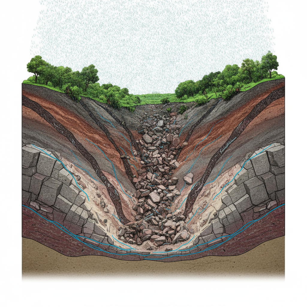
Ancient crystalline rocksShear zonesChemical weatheringSteep slopesHigh rainfall✎ The 2024 Wayanad landslides exemplify how extreme rainfall, combined with ancient geological weaknesses and chemical weathering, can trigger catastrophic debris flows in the Western Ghats.
Subject Relevance — Where This Topic Fits
- GS Paper I — Geography: Geomorphic Processes, Landslides and Disaster Management | GS Paper III — Disaster Management and Environmental Conservation
- Prelims: Western Ghats, landslide susceptibility, shear zones, debris flow, chemical weathering, geomorphic threshold, monsoon variability, NDMA guidelines, geo-heritage sites, LiDAR technology
- Essay: Environmental degradation and human vulnerability: The case of Wayanad landslides, Climate change and geological hazards: A paradigm shift in disaster risk reduction
Quick Revision: The 2024 Wayanad landslides exemplify how extreme rainfall, combined with ancient geological weaknesses and chemical weathering, can trigger catastrophic debris flows in the Western Ghats.
Why is this in the news?
The 2024 Wayanad landslides, triggered by extreme rainfall in July 2024, resulted in catastrophic destruction and fatalities, necessitating a scientific inquiry into the interplay of climatic and geological factors. A peer-reviewed study published in *Landslides* journal in 2025 has elucidated the role of ancient crystalline rock formations, shear zones, and chemical weathering in amplifying the disaster’s scale and impact. This analysis is critical for understanding landslide dynamics in the Western Ghats and informing future mitigation strategies.
Background
- The Western Ghats, a UNESCO World Heritage Site, is a biodiversity hotspot but also highly susceptible to landslides due to its steep slopes, high rainfall, and complex geology.
- Kerala, particularly the Wayanad district, has experienced recurrent landslides, with the 2024 event being one of the most destructive in recent decades.
- Extreme rainfall events in the Western Ghats have increased in frequency and intensity, attributed to climate change and monsoon variability.
- The Punnapuzha river basin, where the landslide originated, is characterized by deeply weathered crystalline rocks and active tectonic deformation.
- Post-disaster assessments have highlighted the need for geological mapping, real-time monitoring, and community-based early warning systems in landslide-prone regions.
- The Government of Kerala has proposed the landslide site as a geo-heritage location to promote research, tourism, and awareness about geological hazards.
Understanding Landslides: Geological and Climatic Interactions in the Western Ghats
- Landslides are rapid mass movements of rock, soil, and debris down a slope, triggered by a combination of geological, hydrological, and climatic factors.
- The 2024 Wayanad landslide was initiated by extreme rainfall (573 mm in 48 hours), which exceeded the geomorphic threshold of the slope, leading to slope failure.
- Geological weaknesses such as shear zones, fractures, and foliations in ancient crystalline rocks (e.g., gneiss, schist) facilitated water infiltration and chemical weathering, reducing rock strength.
- Chemical weathering transforms hard rock into soft, clay-rich material, creating unstable zones that are highly susceptible to landslides during heavy rainfall.
- The landslide evolved into a high-speed debris flow, traveling 8 km and descending 768 metres, due to the steep gradient and narrow valley sections underlain by stronger rocks like metagabbro.
- LiDAR and high-resolution aerial imagery were critical for mapping the failure zone, as the crown of the landslide remained inaccessible due to ongoing instability.
- The study underscores the importance of integrating geological mapping, hydrological modeling, and climate projections to assess landslide susceptibility in the Western Ghats.
- Geo-heritage designation of landslide sites can enhance research, education, and public awareness about geological hazards and their mitigation.
Key Features
| Feature | Significance |
|---|---|
| Extreme rainfall (573 mm in 48 hours) | Primary trigger for slope failure due to rapid water infiltration and increased pore pressure. |
| Ancient crystalline rock formations | Underlying geological structure with pre-existing shear zones, fractures, and foliations, creating planes of weakness. |
| Deep chemical weathering | Transformation of hard rock into soft, weathered material over geological time, reducing slope stability. |
| Highly weathered shear zone near crown | Initial failure point where a first-order stream intersected weakened rock, facilitating detachment. |
| Narrow valley sections with metagabbro | Stronger rock formations that constrained debris flow, amplifying destructive impact. |
Why it Matters
Geological and Geomorphological
- Demonstrates the critical role of pre-existing geological structures in amplifying the impact of extreme weather events.
- Highlights the vulnerability of the Western Ghats to landslides due to prolonged weathering and tectonic activity.
- Provides empirical evidence for the interplay between climate change-induced rainfall intensity and geological instability.
Environmental and Ecological
- Underscores the fragility of hill slope ecosystems in the Western Ghats, a biodiversity hotspot, to anthropogenic and natural stressors.
- Reveals the cascading effects of landslides on river systems (e.g., Punnapuzha) through sediment deposition and altered hydrology.
Disaster Management and Mitigation
- Illustrates the limitations of rainfall-based early warning systems in addressing geological predispositions.
- Emphasises the need for integrated geological and hydrological risk assessments in landslide-prone regions.
Challenges
1. Geological Hazard Prediction
- Difficulty in accurately predicting landslide initiation zones due to complex interactions between weathering, fractures, and rainfall.
- Limited access to high-risk zones (e.g., crown areas) hinders real-time monitoring and mitigation efforts.
UPSC Link: Geographical features – Landslides
2. Climate-Resilient Infrastructure
- Inadequacy of existing infrastructure (e.g., drainage systems, retaining walls) in withstanding extreme rainfall-triggered debris flows.
- Urbanisation and land-use changes in hill slopes exacerbate vulnerability to landslides.
UPSC Link: Disaster Management – Mitigation
3. Multi-Hazard Risk Integration
- Challenge of integrating geological, hydrological, and meteorological data for comprehensive risk mapping.
- Lack of standardised protocols for post-disaster geological surveys and long-term monitoring.
UPSC Link: Disaster Management – Preparedness
Challenges — UPSC Perspective
| Issue | Concern |
|---|---|
| Limited geological data | Insufficient high-resolution mapping of shear zones and weathered layers in landslide-prone regions. |
| Early warning systems | Rainfall thresholds alone are inadequate; need for geological and hydrological inputs. |
| Land-use regulation | Unregulated construction and deforestation in hill slopes increase instability. |
| Post-disaster rehabilitation | Long-term geological and ecological recovery challenges in affected valleys. |
| Cross-disciplinary coordination | Gaps between geological surveys, disaster management agencies, and local governance. |
Way Forward
- Conduct high-resolution geological and geomorphological mapping of the Western Ghats using LiDAR and drone surveys to identify shear zones and weathered layers.
- Develop integrated early warning systems combining meteorological, hydrological, and geological data for real-time landslide prediction.
- Enforce strict land-use regulations in hill slope regions, including restrictions on deforestation and unplanned construction.
- Strengthen infrastructure resilience through the construction of debris flow barriers, improved drainage systems, and slope stabilisation measures.
- Establish a national database for landslide-prone zones, incorporating geological, hydrological, and historical disaster data for policy formulation.
- Promote community-based disaster preparedness programs, including training in evacuation protocols and awareness of geological risks.
- Encourage interdisciplinary research collaborations between geologists, hydrologists, climatologists, and disaster management experts.
UPSC Value Addition
Keywords for Mains Answer-Writing
Landslides in India · Western Ghats geology · Debris flow dynamics · Climate change and natural disasters · Geological shear zones · Wayanad landslides 2024 · Geomorphological processes · Disaster risk reduction · National Disaster Management Authority (NDMA) · National Landslide Susceptibility Mapping Programme · Geological Survey of India (GSI) · Western Ghats ecology
Concept Flow
Extreme monsoon rainfall → Rapid infiltration into fractures and shear zones → Increased pore pressure and reduced slope stability → Pre-existing geological weaknesses (shear zones, weathered rock) → Initial slope failure near crown of the valley → Detachment of large rock block → Transformation into high-velocity debris flow → Debris flow constrained by valley morphology and stronger rock layers (metagabbro) → Amplification of destructive impact → Widespread destruction along 8 km path with 768 m vertical descent → Ecological and infrastructural damage in Punchirimattam, Mundakkai, Chooralmala
Prelims Practice Questions
Q1. Consider the following statements regarding the 2024 Wayanad landslides:
1. The landslide was triggered by extreme rainfall of nearly 573 mm within 48 hours.
2. The debris flow travelled approximately 8 km and descended about 768 metres.
3. The study attributes the disaster solely to anthropogenic climate change.
4. The affected area is underlain by ancient crystalline rocks with natural planes of weakness.
How many of the above statements are correct?
- Only one
- Only two
- Only three
- All
Answer: All — Statements 1, 2, and 4 are correct. Statement 3 is incorrect as the study highlights the interplay of climate and geological factors, not climate change alone.
Q2. Assertion (A): The Western Ghats are geologically stable and less prone to landslides.
Reason (R): The Western Ghats are composed of ancient crystalline rocks that have undergone repeated deformation over millions of years, creating natural planes of weakness.
- Both A and R are true, and R is the correct explanation of A
- Both A and R are true, but R is not the correct explanation of A
- A is true, but R is false
- A is false, but R is true
Answer: ? — Assertion (A) is false because the Western Ghats are geologically unstable due to their ancient crystalline rock formations and structural weaknesses. Reason (R) is true and correctly explains the geological instability.
Mains Practice Question
✍ The 2024 Wayanad landslides exemplify the catastrophic consequences of the interplay between extreme climatic events and geological vulnerabilities. Critically analyse this statement with reference to the geological and geomorphological factors that exacerbated the disaster. Also, outline the institutional mechanisms available in India for landslide risk reduction and management. (15 Marks)
Approach: MODEL-ANSWER SKELETON:
1. **Introduction (2 marks)**: Define landslides and their classification (e.g., debris flow, rockslide). Briefly introduce the 2024 Wayanad landslides as a case study of the climate-geology nexus.
2. **Geological and Geomorphological Factors (6 marks)**:
– **Ancient Crystalline Rocks**: Explain the composition of the Western Ghats (e.g., gneiss, schist) and their long-term deformation creating shear zones, fractures, and foliations.
– **Weathering and Weakness**: Describe how chemical weathering transforms hard rock into soft, weathered material, reducing slope stability.
– **Valley Geomorphology**: Explain how narrow valleys and first-order streams in the Punnapuzha river catchment contributed to the rapid debris flow and its destructive trajectory.
– **Rainfall-Triggered Mechanism**: Detail how extreme rainfall (573 mm in 48 hours) increased pore water pressure, leading to slope failure.
3. **Institutional Mechanisms for Landslide Risk Reduction (5 marks)**:
– **National Landslide Susceptibility Mapping Programme (NLSMP)**: Role of the Geological Survey of India (GSI) in mapping landslide-prone zones.
– **National Disaster Management Authority (NDMA)**: Guidelines for landslide risk management, early warning systems, and community preparedness.
– **State-Level Mechanisms**: Kerala’s disaster management plans, including the Kerala State Disaster Management Authority (KSDMA) and real-time monitoring systems.
– **Legal Framework**: Reference the Disaster Management Act, 2005, and the National Disaster Response Force (NDRF) deployment protocols.
4. **Conclusion (2 marks)**: Emphasise the need for integrated disaster risk reduction strategies that combine geological mapping, climate adaptation, and community awareness. Highlight gaps in implementation and the importance of multi-disciplinary approaches.
Source: The Hindu
Generated by AanyaAi for educational purpose.

- Jal Arpan: 1850+ Gram Panchayats Join Hands for Rural Water Supply - October 3, 2026
- भारत ने किया 5.56 किमी मुक्त अंतरिक्ष क्वांटम की वितरण लिंक का सफल परीक्षण - October 3, 2026
- Great Indian Bustard Reintroduction: 10-Year Effort Bears Fruit in Rajasthan - October 3, 2026

No Comments