


09 Aug Wayanad Landslides 2024: Climate-Geology Link Explained for UPSC
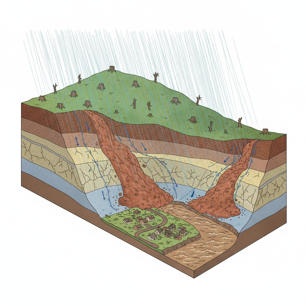
Extreme rainfallGeological weaknessesValley formations✎ The 2024 Wayanad landslides were triggered by extreme rainfall but were fundamentally governed by pre-existing geological weaknesses—shear zones, chemical weathering, and valley topography—which determined the initiation…
Subject Relevance — Where This Topic Fits
- GS Paper I — Geographical features and their location-changes | GS Paper III — Disaster and disaster management
- Prelims: Western Ghats, landslide susceptibility, shear zones, debris flow, hydro-meteorological hazards, NDMA Guidelines on Landslides, Punnapuzha river basin, Wayanad district, Kerala
- Essay: The interplay of natural and anthropogenic factors in shaping environmental disasters: A case study of the Wayanad landslides
Quick Revision: The 2024 Wayanad landslides were triggered by extreme rainfall but were fundamentally governed by pre-existing geological weaknesses—shear zones, chemical weathering, and valley topography—which determined the initiation, propagation, and destructiveness of the event.
Why is this in the news?
The 2024 Wayanad landslides, triggered by extreme rainfall (573 mm in 48 hours) on July 30, 2024, resulted in catastrophic destruction due to the interplay of geological weaknesses and valley formations. A recent study published in *Landslides* journal by researchers from the University of Kerala, IISER Mohali, and Savitribai Phule Pune University highlights how pre-existing geological structures and prolonged chemical weathering exacerbated the disaster, underscoring the need for integrated disaster risk reduction strategies in ecologically fragile regions like the Western Ghats.
Background
- The Western Ghats, a UNESCO World Heritage Site, are a biodiversity hotspot but also highly susceptible to landslides due to their geological complexity and intense monsoon rainfall.
- Kerala, particularly Wayanad district, has experienced recurrent landslides, with the 2024 event being one of the most devastating in recent history.
- The Punnapuzha river basin, where the landslide originated, is characterized by steep slopes, deep valleys, and a history of tectonic activity, making it prone to slope failures.
- Climate change has intensified monsoon variability, increasing the frequency and intensity of extreme rainfall events, which act as primary triggers for landslides in the region.
- Geological studies in the Western Ghats have identified ancient crystalline rocks with pervasive shear zones, fractures, and foliations, which are prone to weathering and slope instability.
- The 2024 landslide followed a pattern observed in other Himalayan and Western Ghats regions, where geological predisposition combined with hydro-meteorological triggers leads to high-impact disasters.
What are landslides, and how do they occur in the Western Ghats?
- Landslides are the rapid downward movement of rock, soil, and debris along a slope, driven by gravity, and are classified into falls, topples, slides, spreads, and flows based on material and movement type.
- In the Western Ghats, landslides predominantly occur as debris flows or debris avalanches, where water-saturated material moves rapidly down steep slopes, often transforming into destructive torrents.
- The region’s geological framework consists of Precambrian crystalline rocks (e.g., gneisses, schists, charnockites) that have undergone multiple phases of deformation, creating structural weaknesses such as shear zones and faults.
- Chemical weathering, particularly hydrolysis and oxidation, weakens these rocks over time, converting hard rock into soft, clay-rich material that is highly susceptible to failure during heavy rainfall.
- Topographic factors, including steep slopes, narrow valleys, and concave slope profiles, enhance the concentration of runoff and increase pore-water pressure, reducing slope stability.
- Anthropogenic activities such as deforestation, quarrying, and unplanned construction further exacerbate landslide risks by destabilizing slopes and altering drainage patterns.
- The disaster’s scale was amplified by the **runout distance** of nearly 8 km and a vertical descent of 768 metres, which is atypical for landslides in the region and highlights the role of valley morphology in disaster propagation.
Key Features
| Feature | Significance |
|---|---|
| Extreme rainfall (573 mm in 48 hours) | Triggered the initial slope failure by saturating the weathered rock mass, reducing shear strength and initiating the landslide. |
| Ancient crystalline rock mass with shear zones | Provided pre-existing planes of weakness that facilitated water infiltration, chemical weathering, and eventual detachment of large rock blocks. |
| Highly weathered shear zone near crown | Acts as the initiation point of the landslide due to reduced rock integrity and high water pressure during intense rainfall. |
| Narrow valley sections underlain by metagabbro | Acted as constrictions that accelerated debris flow velocity, increasing destructive potential along the 8 km travel path. |
| Debris flow (8 km travel, 768 m descent) | Transformed a slope failure into a high-momentum mass movement, amplifying destruction in Punchirimattam, Mundakkai, and Chooralmala. |
Why it Matters
Geological and Geomorphological
- Demonstrates the critical role of pre-existing geological structures (shear zones, fractures) in amplifying the impact of extreme weather events in landslide-prone regions.
- Highlights the vulnerability of deeply weathered crystalline rock masses in the Western Ghats to rapid degradation under prolonged rainfall.
- Illustrates how valley morphology (narrow sections) can exacerbate the destructive potential of debris flows by increasing flow velocity and energy.
Climate-Weather Interface
- Provides empirical evidence of the increasing frequency and intensity of extreme rainfall events in the Western Ghats, linked to climate change.
- Underscores the need for integrating climate projections into landslide risk assessment and mitigation strategies for hilly regions.
- Reinforces the concept of ‘compound hazards,’ where geological and meteorological factors interact to produce catastrophic outcomes.
Disaster Management and Governance
- Exposes gaps in real-time landslide monitoring and early warning systems, particularly in remote and geologically complex terrains.
- Emphasises the importance of post-disaster geological investigations in understanding failure mechanisms to inform future mitigation efforts.
- Raises questions about the adequacy of existing land-use policies and construction regulations in ecologically fragile hill regions.
Scientific and Research
- Advances understanding of landslide initiation and propagation in the Western Ghats, a globally recognised biodiversity hotspot.
- Demonstrates the value of interdisciplinary research (geology, geomorphology, climatology) in addressing complex environmental hazards.
- Highlights the role of advanced technologies (LiDAR, drone imagery) in inaccessible terrains for geological hazard assessment.
Challenges
1. Geological Vulnerability Mapping
- Identifying and mapping shear zones, fractures, and weathered rock masses in hilly terrains to prioritise risk assessment.
- Integrating geological data with climate projections to anticipate high-risk zones for landslides.
UPSC Link: Geographical features of India
2. Extreme Weather Event Prediction
- Enhancing the accuracy and lead time of rainfall forecasts for landslide-prone regions using high-resolution weather models.
- Developing region-specific rainfall thresholds for landslide initiation based on geological and hydrological data.
UPSC Link: Climate change and its impact
3. Early Warning Systems
- Deploying real-time monitoring systems (e.g., piezometers, inclinometers) in high-risk shear zones to detect slope instability.
- Establishing community-based early warning systems with clear communication protocols for rapid evacuation.
UPSC Link: Disaster management
4. Land-Use Regulation and Enforcement
- Implementing strict zoning laws to restrict construction in identified shear zones and high-risk valleys.
- Enforcing building codes that account for geological hazards, including slope stability assessments for new developments.
UPSC Link: Conservation and environmental degradation
5. Post-Disaster Reconstruction and Rehabilitation
- Ensuring geological stability assessments before reconstruction in landslide-affected areas to prevent recurrence.
- Incorporating climate-resilient design principles in rebuilding infrastructure to withstand future extreme events.
UPSC Link: Disaster management
Challenges — UPSC Perspective
| Issue | Concern |
|---|---|
| Limited geological data for hilly regions | Inadequate baseline data on shear zones, fractures, and weathered rock masses hampers risk assessment. |
| Climate change intensifying rainfall patterns | Increased frequency of extreme rainfall events overwhelms existing mitigation and warning systems. |
| Poor enforcement of land-use regulations | Unregulated construction in high-risk zones exacerbates vulnerability to landslides. |
| Inadequate early warning dissemination | Lack of real-time monitoring and community awareness delays evacuation responses. |
| Post-disaster geological investigations lagging | Delayed or incomplete post-event studies hinder learning and future preparedness. |
Way Forward
- Conduct comprehensive geological mapping of the Western Ghats to identify shear zones, fractures, and weathered rock masses for risk stratification.
- Develop region-specific rainfall thresholds for landslide initiation by integrating geological, hydrological, and meteorological data.
- Deploy real-time slope monitoring systems (e.g., LiDAR, piezometers) in high-risk shear zones to enable early detection of instability.
- Strengthen community-based early warning systems with clear communication protocols and regular drills for rapid evacuation.
- Enforce strict land-use regulations, including zoning laws and building codes, to restrict construction in identified high-risk areas.
- Integrate climate projections into landslide risk assessment and mitigation strategies to address future extreme weather scenarios.
- Promote interdisciplinary research collaborations between geologists, climatologists, and disaster management experts to advance understanding of compound hazards.
- Establish a national database of landslide events, including geological and meteorological data, to inform policy and preparedness.
UPSC Value Addition
Keywords for Mains Answer-Writing
Wayanad landslides 2024 · Western Ghats geology · debris flow dynamics · geological shear zones · climate-geology interplay · Punnapuzha river catchment · high-velocity mass movements · geological weathering processes · landslide mitigation strategies · disaster risk reduction · geomorphological vulnerabilities · crystallines rocks of Western Ghats
Concept Flow
Extreme rainfall (573 mm in 48 hours) → Saturation of weathered rock mass → Reduction in shear strength → Initiation of slope failure in shear zone → Pre-existing geological weaknesses (shear zones, fractures) → Chemical weathering → Formation of deeply weathered material → Increased vulnerability to detachment → Detachment of large rock block → High-speed debris flow → Travel of 8 km with 768 m descent → Amplification of destruction in narrow valley sections → Interaction of geological and meteorological factors → Compound hazard → Catastrophic landslide in Western Ghats → Post-disaster geological investigations → Identification of failure mechanisms → Informing future mitigation and policy
Prelims Practice Questions
Q1. Consider the following statements regarding the 2024 Wayanad landslides:
1. The disaster was triggered by rainfall exceeding 573 mm within 48 hours.
2. The landslide originated in a highly weathered shear zone near the crown.
3. The debris flow travelled approximately 8 km and descended about 768 metres.
4. The underlying rock type in the affected area is primarily sedimentary.
How many of the above statements are correct?
- Only one
- Only two
- Only three
- All four
Answer: Only three — Statements 1, 2, and 3 are correct based on the study. Statement 4 is incorrect as the area is underlain by ancient crystalline rocks, not sedimentary.
Q2. Assertion (A): The 2024 Wayanad landslides were primarily caused by extreme rainfall.
Reason (R): Geological weaknesses such as shear zones and fractures significantly influenced the scale and destructive impact of the landslides.
In the context of the given statements, which of the following is correct?
- Both A and R are true, and R is the correct explanation of A
- Both A and R are true, but R is not the correct explanation of A
- A is true, but R is false
- A is false, but R is true
Answer: A is true, but R is false — Assertion (A) is true as extreme rainfall triggered the landslides. Reason (R) is also true and provides the geological context for the disaster’s scale, but R does not directly explain A.
Mains Practice Question
✍ The 2024 Wayanad landslides exemplify the catastrophic consequences of the interplay between extreme climatic events and geological vulnerabilities. Critically analyse the geological and geomorphological factors that amplified the disaster’s scale and impact. (15 Marks)
Approach: MODEL-ANSWER SKELETON:
1. **Introduction (2 Marks)**: Define landslides and their classification (e.g., debris flow, rockslide). State the 2024 Wayanad event as a case study of climate-geology interaction.
2. **Geological Factors (5 Marks)**:
– **Rock Type and Structure**: Explain the role of ancient crystalline rocks (e.g., gneiss, schist) in the Western Ghats, including their foliation, fractures, and shear zones.
– **Weathering Processes**: Detail chemical weathering leading to deep regolith formation and loss of rock cohesion.
– **Structural Weaknesses**: Highlight pre-existing planes of weakness (e.g., joints, faults) that facilitated slope failure.
3. **Geomorphological Factors (5 Marks)**:
– **Valley Configuration**: Describe the concave valley geometry of the Punnapuzha river catchment, which channelled debris flow.
– **Slope Angle and Relief**: Emphasise the steep gradient (~768 m descent over 8 km) and its role in high-velocity debris movement.
– **Drainage Patterns**: Explain how first-order streams intersected weakened zones, accelerating water infiltration and pore-pressure buildup.
4. **Climate-Geology Interplay (3 Marks)**:
– **Extreme Rainfall**: Quantify the 573 mm rainfall in 48 hours and its role in triggering slope failure.
– **Feedback Mechanisms**: Describe how rainfall exacerbated existing geological weaknesses (e.g., increased pore pressure, reduced shear strength).
5. **Conclusion (2 Marks)**: Summarise the findings and underscore the need for integrated disaster risk reduction strategies combining geological mapping, land-use planning, and early warning systems.
Source: The Hindu
Generated by AanyaAi for educational purpose.

- गृह मंत्री ने मध्य प्रदेश में गौपालक सम्मेलन का किया उद्घाटन, नए अपराध कानूनों पर प्रदर्शनी का किया शुभारंभ - October 3, 2026
- Jal Arpan: 1850+ Gram Panchayats Join Hands for Rural Water Supply - October 3, 2026
- भारत ने किया 5.56 किमी मुक्त अंतरिक्ष क्वांटम की वितरण लिंक का सफल परीक्षण - October 3, 2026

No Comments