


09 Aug Wayanad Landslides 2024: Climate-Geology Link for UPSC State PCS
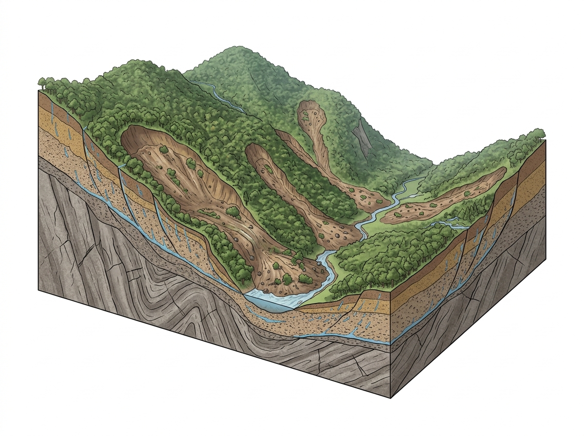
Extreme rainfallSteep slopesGeological weaknessesWeathered rocksLandslide triggers✎ The 2024 Wayanad landslides were triggered by extreme rainfall but amplified by geological weaknesses such as shear zones and chemical weathering in ancient crystalline rocks, leading to a high-speed debris flow that caused…
Subject Relevance — Where This Topic Fits
- GS Paper I — Geography (Geomorphology, Climate Change, Disaster Management) | GS Paper III — Disaster and Disaster Management
- Prelims: Western Ghats, Debris flow, Shear zones, LiDAR, Chemical weathering, Punnapuzha river, Wayanad district, Geological mapping
- Essay: Climate Change and Geological Fragility: A Case for Sustainable Development in Fragile Ecosystems
Quick Revision: The 2024 Wayanad landslides were triggered by extreme rainfall but amplified by geological weaknesses such as shear zones and chemical weathering in ancient crystalline rocks, leading to a high-speed debris flow that caused widespread destruction.
Why is this in the news?
The 2024 Wayanad landslides, triggered by extreme rainfall of 573 mm within 48 hours, resulted in catastrophic destruction, prompting a multidisciplinary study that highlighted the critical role of geological weaknesses in amplifying the disaster’s scale. The findings underscore the need for integrated disaster risk reduction strategies that account for both climatic extremes and underlying geomorphological vulnerabilities in the Western Ghats.
Background
- The Western Ghats, a UNESCO World Heritage Site, is a biodiversity hotspot and a region prone to landslides due to its steep slopes, high rainfall, and complex geological structures.
- Wayanad district in Kerala is particularly susceptible to landslides due to its geological composition, which includes ancient crystalline rocks subjected to prolonged weathering and deformation.
- The 2024 Wayanad landslides occurred on the night of July 30, 2024, following exceptionally heavy rainfall, which triggered a massive slope failure in the upper catchment of the Punnapuzha river.
- The disaster evolved into a high-speed debris flow, travelling nearly 8 km and descending 768 metres, causing widespread destruction in Punchirimattam, Mundakkai, and Chooralmala.
- A study published in the journal *Landslides* by researchers from the University of Kerala, IISER Mohali, and Savitribai Phule Pune University provided detailed insights into the interplay of climate and geology in the disaster.
- The study proposed the landslide site as a geo-heritage location to promote research and tourism, emphasizing the need for further geological studies in the region.
What are Landslides and Their Triggers?
- Landslides are the rapid movement of rock, soil, and debris down a slope, often triggered by a combination of natural and anthropogenic factors.
- Primary triggers include intense rainfall, seismic activity, slope steepness, and human interventions such as deforestation and construction.
- In the Western Ghats, geological factors such as shear zones, fractures, and foliations in ancient crystalline rocks significantly influence landslide susceptibility.
- Chemical weathering over millions of years transforms hard rock into soft, weathered material, which is more prone to failure during heavy rainfall.
- Debris flows, a type of landslide, involve the rapid movement of water-saturated debris, which can travel long distances and cause extensive damage.
- The 2024 Wayanad landslides exemplify how extreme rainfall can interact with geological weaknesses to produce catastrophic outcomes.
- Geological mapping and LiDAR technology are critical tools for assessing landslide risks and understanding failure mechanisms.
- The study’s findings highlight the importance of integrating geological and climatic data in disaster risk reduction strategies.
UPSC Value Addition
Keywords for Mains Answer-Writing
Wayanad landslides 2024 · Western Ghats geology · debris flow dynamics · climate-geology interplay · shear zones and weathering · landslide triggers · Punnapuzha river catchment · geological weaknesses · debris avalanche · geomorphological factors · monsoon rainfall intensity · landslide geo-heritage · geological mapping · LiDAR in disaster studies · Western Ghats landslide susceptibility · landslide mitigation strategies
Prelims Practice Questions
Q1. Consider the following statements regarding the 2024 Wayanad landslides:
1. The landslide was triggered by extreme rainfall measuring nearly 573 mm within 48 hours.
2. The debris flow travelled approximately 8 km and descended about 768 metres.
3. The landslide originated in a region underlain by sedimentary rocks.
4. The study utilised drone-mounted LiDAR for investigating the upper failure zone.
How many of the above statements are correct?
- Only one
- Only two
- Only three
- All
Answer: Only three — Statements 1, 2, and 4 are correct. Statement 3 is incorrect as the affected area is underlain by ancient crystalline rocks, not sedimentary rocks.
Q2. Assertion (A): The 2024 Wayanad landslides were solely attributed to extreme monsoon rainfall.
Reason (R): Geological weaknesses such as shear zones and fractures significantly influenced the scale and destructive impact of the landslide.
Options:
A. Both A and R are true, and R is the correct explanation of A.
B. Both A and R are true, but R is not the correct explanation of A.
C. A is true, but R is false.
D. A is false, but R is true.
Answer: ? — Assertion (A) is false because the landslides were not solely attributed to extreme rainfall; geological weaknesses played a critical role. Reason (R) is true and correctly explains the assertion.
Q3. Match the following geological features with their descriptions in the context of the 2024 Wayanad landslides:
Column I
1. Shear zones
2. Chemical weathering
3. Debris flow
4. LiDAR
Column II
A. Transformation of hard rock into soft material due to rainwater infiltration
B. Planes of weakness created by repeated deformation in crystalline rocks
C. High-speed movement of rock, soil, and vegetation down a slope
D. Remote sensing technique using laser pulses to map terrain
Options:
A. 1-B, 2-A, 3-C, 4-D
B. 1-A, 2-B, 3-D, 4-C
C. 1-D, 2-C, 3-B, 4-A
D. 1-C, 2-D, 3-A, 4-B
Answer: ? — Correct match: 1-B (Shear zones are planes of weakness in crystalline rocks), 2-A (Chemical weathering transforms hard rock into soft material), 3-C (Debris flow is the high-speed movement of material), 4-D (LiDAR is a remote sensing technique using laser pulses).
Mains Practice Question
✍ Critically analyse the interplay between climate and geology in the initiation and amplification of the 2024 Wayanad landslides. Substantiate your analysis with reference to the geological and geomorphological characteristics of the Western Ghats. (15 Marks)
Approach: MODEL-ANSWER SKELETON:
1. **Introduction (2 marks)**
– Briefly define landslides and their classification (e.g., debris flow, rockslide).
– Contextualise the 2024 Wayanad landslides as a case study of climate-geology interaction.
2. **Role of Climate (4 marks)**
– Extreme rainfall (573 mm in 48 hours) as the primary trigger.
– Link to monsoon variability and climate change projections for the Western Ghats.
– Cite IMD data or studies on increasing rainfall intensity in the region.
3. **Geological and Geomorphological Factors (5 marks)**
– Ancient crystalline rocks and repeated deformation creating shear zones, fractures, and foliations.
– Chemical weathering of hard rock into soft, weathered material due to rainwater infiltration.
– Valley formations and slope geometry (e.g., narrow sections underlain by stronger rocks like metagabbro).
– Role of first-order streams in initiating slope failure.
4. **Amplification Mechanisms (2 marks)**
– Rapid infiltration of rainwater increasing pore water pressure.
– Transformation of the slope into a high-speed debris flow due to the combination of rock, soil, and vegetation.
– Destructive impact amplified by the 8 km travel distance and 768 m descent.
5. **Comparative Perspective (1 mark)**
– Contrast with other landslide-prone regions in India (e.g., Himalayas, Northeast) to highlight regional variations.
6. **Conclusion (1 mark)**
– Emphasise the need for integrated disaster risk reduction strategies combining climate adaptation and geological mapping.
Source: The Hindu
Generated by AanyaAi for educational purpose.

- Jal Arpan: 1850+ Gram Panchayats Join Hands for Rural Water Supply - October 3, 2026
- भारत ने किया 5.56 किमी मुक्त अंतरिक्ष क्वांटम की वितरण लिंक का सफल परीक्षण - October 3, 2026
- Great Indian Bustard Reintroduction: 10-Year Effort Bears Fruit in Rajasthan - October 3, 2026

No Comments